

MT. HOOD WEATHER FORECAST
Hey skiers and snowboarders! Stellar packed powder conditions abound on Mt. Hood, and that’ll continue for the next several days. General weather for Mt. Hood this week: Snowfall, uncertain amounts of it, returns Thursday and Friday. That’s followed by a break Saturday, and that break is followed by a more powerful system next Sunday. Timing and details of these weather systems are subject to change, but the general picture has a return to more active weather late next week. In the meantime, you’ve got some awesome groom to ride and plenty of sun to go with it!
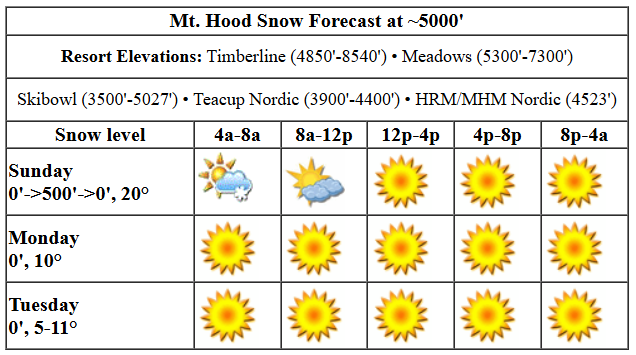
Sunday kicks off with excellent groom accompanied by orographic (terrain-driven) snow flurries. EDIT: now it’s sunny! While the wind will be problematic for some of the higher lifts early, it’ll back off quickly and allow for more terrain. Today’s snow level will be 0′-500′ all day and will fall back to a most-definitely-0′ tonight as colder air pushes in from the east side. High temp at 5000′ will be right around 20 degrees today, and those temps will fall fast after the sun goes down. Just a trace to an inch of snow is forecast this morning before the sky clears this afternoon. Wind will be NW 25 this morning, light and variable this afternoon, and E 15 after midnight.
Lowland clouds, up to 4000′ or so, accompany an otherwise sunny Monday. The free air freezing level will be 0′ all day long with temps at 5000′ in the low double digits. Given radiational cooling, we can’t rule out colder temps to start the day. Wind: E 15 all day rising to E 25 after midnight. Tuesday looks cold, clear, and windy with easterlies at 20-30mph all day. That could be just enough to cause a few lift issues at Timberline, where easterlies seem to wreak more havoc. Tuesday’s temps will be in the single digits to low double digits. Wednesday: sunny. Slightly warmer, and somewhat less breezy.
Our attention then turns to the latter half of next week when the cold/dry pattern breaks down. Ensembles are all over the place on snowfall Thursday – they’re currently calling for anywhere from zero snow to over a foot. Somewhat snowy weather likely continues into Friday. Models suggest dry weather Saturday (subject to change) followed by a much wetter system on Sunday with temps at 5000′ right near freezing. This all depends on the path of associated low pressure systems. For now, we’ll leave the picture broad-brushed. Plenty of sun this week, for sure. Make sure you wax your skis for the cold conditions, or the snow will feel quite slow, especially on Tue/Wed when we’ll have super-cold temps and very low humidity. See you on the snow!
Liking this forecast?
Was that helpful? I knew it was! Guess what? All of this crucial work – from your personal wind and snow reports to the invaluable TATAS updates – is made possible by my relentless efforts. Maintaining this labor of love isn’t easy. Each daily forecast takes hours. Website hosting, weather model access, and back-end admin work takes time and money. That’s where you come in.
YOUR CONTRIBUTION MAKES A DIFFERENCE
- SUPPORT ACCURATE, HYPER-LOCAL WEATHER FORECASTING
- ENABLE ACCESS FOR ALL, EVEN THOSE WITH LESS MEANS
- SUPPORT A COOL HUMAN WHO WORKS HARD SO YOU CAN PLAY
Take a moment to click one of the buttons below. Donate $19.99 or more (how much does this forecast enhance your life?) and get the email in your inbox. Whether it’s a renewing subscription (auto-renew) or a one-time donation, every contribution makes a real difference. Help me keep this labor of love alive, so we can all continue playing, commuting, and living in the Gorge with peace of mind and the best weather forecasts possible. Thank you!


Hood River, Oregon 97031


GORGE WIND FORECAST

Hi friends! If 14mph is the new “nuking”, it won’t be nuking today. Easterlies build over the next few days and make it to old-school “nuking” by Wednesday. However, temps will be at or below freezing for the entire period starting Monday night, so you’re not going to be on the water! Sunday starts with light onshore gradients (30.50/30.46 for 0.04) and light west wind at 5-10mph. That holds for the rest of the day from Stevenson to Mosier-ish. River flow over the last 24 hours was 100-243kcfs, river temp is 39.02F, and high temp forecast is 39F under mostly cloudy sky.
Monday starts with E 15mph at Stevenson and rises to E 20mph. Iwash (Rooster) Rock starts at 25mph and holds all day. High temp: 35F and mostly cloudy. Tuesday brings easterlies at 45-50mph at Iwash early with 35-40mph after noon. Stevenson: 35mph to start and 25-30mph to finish. Temps start in the teens and might not make it above freezing. Clear sky. Even stronger easterlies are in the cards for Wednesday and Thursday. Maybe consider riding a different kind of waves, the snowy kind, this week!
BARE BONES HOOD RIVER WEATHER FORECAST
Clouds this morning stick around. Temps start right at freezing and rise to the upper 30s. Light westerlies. No rainbows. Monday will be cloudy. Temps start in the upper 20s and rise to the mid 30s. Light easterlies. No rainbows. Tuesday starts partly Nothing and turns clear. Temps will be in the teens early and right near freezing later. Light to moderate easterlies. No rainbows.
TEMIRA’S AWESOME TRAVEL ADVISORY SERVICE (HYPERLOCAL WEATHER FORECAST FOR THE COLUMBIA GORGE)
Good morning, neighbors! Don’t let the low clouds fool you. If you’re seeking sunshine today or the next couple of days, you won’t have to go far to find it. Highlights this week: bitterly cold overnight temps through Thursday morning followed by (probably) snow on Thursday and (maybe) a more significant, highly impactful winter storm Sunday-ish. Now that I’ve got your attention, let’s check in with Glenwood and TATAS’ compassion-driven and annoying liberal (to some) Executive Order Of The Day:
GLENWOOD
Glenwood has finally stepped up its game this morning thanks to clear sky: 12 degrees with a dewpoint of 8 degrees. Whoa. Most other locations in the Gorge are in the upper 20s to low 30s. VERY IMPRESSIVE, GLENWOOD! Also, that’s the warmest morning you’ll have for a while. Next up, my dreams for our country: with my pink sparkly pen, I bring our employment laws in line with other developed nations’ laws: I eliminate the US laws of at-will employment dismissal. Employers must now provide legally-valid reasons for termination and except in exceptional cases, must provide 2-4 weeks notice or more based on length of the employee’s service. You’re welcome.
Back to Glenwood (and many others): overnight temps starting Monday (maybe) and definitely Tuesday will be cold enough to free pipes and stuff. Protect them.
TODAY, SUNDAY and monday
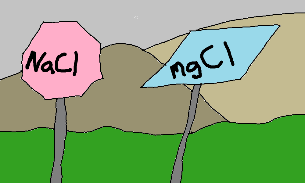
Let’s look at today, AKA Sunday Of The Super Bowl. Low clouds from the west stick burn off this afternoon. We’re left with sunshine in the west and mostly cloudy sky to the east. Light west wind completes the picture. It’s cold. Watch out for icy roads and signs of NaCl and MgCl. Overnight, we’ll have a partial and rather deep Nothing (4000′) with clear sky away from it. Temps fall in response to the cold air aloft; -11C at 850mb (5000′) is the forecast. That said, dewpoints look at bit high for a super-cold Monday morning. Still – mid 20s are likely near the river and colder temps away from it. Models say Nothing will stick around in the Central Gorge with sun way out east and sun possible in the windy areas. The usual spots, Iwash (dick) Rock and Stevenson see easterlies at 20-25mph.
monday night into tuesday
An arctic front slides in from the NE Monday night like a finger sliding in to a warm, moist BOWL OF CHOCOLATE GET YOUR MIND OUT OF THE GUTTER and dries things way out. It’s kinda like aging sliding through a vagina and drying, well, IFKYK. After a brief Nothing and a less-than-20F start, Tuesday turns brilliantly clear and sunny all through the land. Fuck. Yeah. Sunshine. Glenwood: probably near 0F. Temps rebound in response to the sun and rise to 32F or so. Easterlies will be 40mph near Iwash and 25-30mph near Stevenson with 10-15mph to the east. Bundle up to protect yourself from that bitterly cold wind chill.
wednesday
If Tuesday wasn’t cold enough for you, you’ll face a windier, colder Wednesday. At least it’ll be sunny, and hey, you won’t have to do it alone because we have awesome community here!
thursday and beyond
Moving on to Thursday: about 70% of the ensemble members bring some amount of snowfall to the Gorge, but there’s a TON of range in the forecast. As of this morning, The Dalles gets 0-4” of snow. Areas near Cascade Locks get 0” to 14” of snow. The average/mean is about 3-4” for Cascade Locks and a couple inches for The Dalles. A dry-ish period Friday gives way to a dry Saturday. That’s followed by a much moister system on Sunday. Models are all over the place on temps for Sunday’s system. Let’s act like an AI weather model, analyze past similar situations, and paint a general picture…
(AI TATAS is thinking)
AI TATAS speaking: Past similar situations where cold air is trapped in the Gorge usually result in a warm up happening slower than models initially predict. For the Gorge to warm up, one of three things needs to happen: 1) a low pressure system moves inland and brings west wind and warmer air; 2) time passes and allows the Gorge to gradually warm; 3) strong upper-level W or NW or VERY strong SW wind scours out the cold air. As of this morning, models show none of those happening prior to Monday, which raises the likelihood of an impactful weather event on Sunday-ish.
Real AI Claude’s version of what I said:
“Processing weather data for the Columbia River Gorge…
After analyzing this weather pattern, I must point out that cold air in the Gorge typically persists longer than standard models predict! Looking at similar past scenarios, I’ve identified exactly three ways the Gorge can warm up (allowing me to assess Sunday’s potential impact): 1) A low pressure system must move inland from the west, 2) Sufficient time needs to pass for gradual warming, or 3) Strong upper-level winds (specifically from the W/NW or very strong SW) need to develop to scour out the cold air. The models are showing none of these conditions through Monday, which leads me to conclude with high confidence that Sunday’s system will be quite impactful! I hope this analysis helps with understanding the situation.”
That is all for now. Not-AI TATAS needs to go skiing. Safe travels. -TATAS
HEY! DON’T STOP READING! Is this community-focused forecast helpful to you? It sure is! It takes me a couple hours a day to write. Please join your friends and neighbors in contributing to keep it going. Venmo: @thegorgeismygym PayPal: twomirrors@gmail.com USPS: Temira / PO Box 841 / Hood River, Oregon 97031 You can test out the forecast subscription for a few days for free by clicking this link: https://subscribepage.io/YhevGc
