

MT HOOD WEATHER FORECAST
Hey skiers and snowboarders! The weather on our favorite volcano has switched over to rain this morning, and rain it shall remain today and at least part of Monday. Sunny, warm weather on Tuesday gives way to atmospheric instability and potential showers on Wednesday. After that: we fall right back into winter with colder temps and intermittent light to moderate snowfall all the way through the extended forecast period.
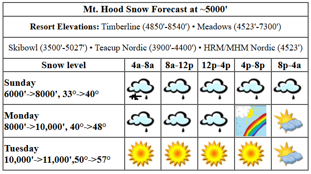
sunday
Today will not have snow. Sunday’s Mt. Hood weather is just drizzle. Actually, after I wrote this, it started snaining. Let’s call it mixed precip for a bit then rain. The snow level starts around 6000′ and rises to 8000′ with temps at 5000′ rising from 33F to 40F. About 0.25” rain is forecast during the day followed by a trace to 0.1” overnight. Wind starts at W 30 and rises to W 45 this afternoon, potentially causing some lift problems. Snow surface: wet pack.
monday’s mt hood weather
Monday, thanks to moderately strong west wind to start, holds on to some orographic drizzle for a good portion of the day. The snow level will be 8000′ in the morning, 8500′ in the afternoon, and 10,000′ after midnight. Temps start around 40F at 5000′ and rise to the upper 40s in the afternoon. Just 0.1” rain or less is forecast over the course of the day. Wind: W 30 in the morning, SW 10-15 in the afternoon, and SW 5-10 overnight under clearing sky.
extended mt hood weather forecast
Tuesday looks warm and sunny. The free air freezing level rises from 10,000′ to 11,000′, and temps rise from 50F to the upper 50s. Wind: less than 15mph out of the S or SW all day. Wednesday looks active! The day starts clear with the freezing level around 11,000′, adds in significant instability and a chance of thunder in the afternoon, and turns cloudy with a chance of flurries overnight as the snow level plummets to 4000′. Details aren’t totally clear on all this, but it looks like we’ll have moderate SSW wind for the period. Starting Thursday, we’re right back into snowy weather. Just a quick heads up: I’m taking off April 1st for a month of silent meditation. I’ll see you at the beginning of May to wrap up ski season!
Was that helpful? I knew it was! Guess what? All of this crucial work – from your personal wind and snow reports to the invaluable TATAS updates – is made possible by my relentless efforts. Maintaining this labor of love isn’t easy. Each daily forecast takes hours. Website hosting, weather model access, and back-end admin work takes time and money. That’s where you come in.
YOUR CONTRIBUTION MAKES A DIFFERENCE
- SUPPORT ACCURATE, HYPER-LOCAL WEATHER FORECASTING
- ENABLE ACCESS FOR ALL, EVEN THOSE WITH LESS MEANS
- SUPPORT A COOL HUMAN WHO WORKS HARD SO YOU CAN PLAY
Take a moment to click one of the buttons below. Donate $19.99 or more (how much does this forecast enhance your life?) and get the email in your inbox. Whether it’s a renewing subscription (auto-renew) or a one-time donation, every contribution makes a real difference. Help me keep this labor of love alive, so we can all continue playing, commuting, and living in the Gorge with peace of mind and the best weather forecasts possible. Thank you!


Hood River, Oregon 97031


GORGE WIND FORECAST

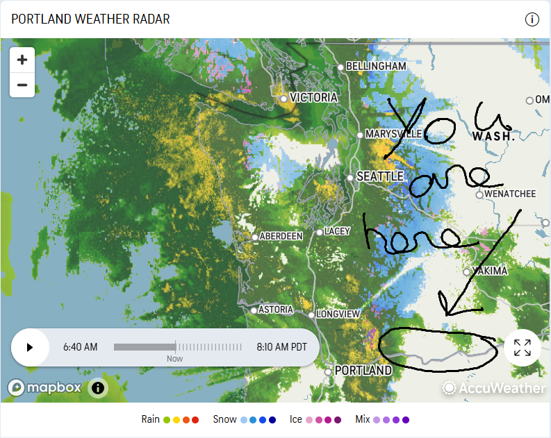
Hi friends! With the exception of early this upcoming week, active weather stretches way out into the future. This sets us up for low-confidence forecasts and low-probability westerlies. Our best chance in the next week appears to be late Wednesday, but it’s a very active setup combined with atmospheric instability – definitely a low-confidence possibility. Sunday kicks off with pressures of 30.18/30.13/30.12 for gradients of 0.05 and 0.01. Models suggest gusty 15-18 max from Stevenson to Viento or possibly Swell today, but we’ll also have rain in the morning and evening. Best chance for wind will be early to mid afternoon, and I’m definitely not saying this is for-sure! River flow over the last 24 hours was 108-171kcfs, river temp is 44.8F, and high temp forecast is 57F.
Monday brings calm weather and wind that can only be characterized as “light westerly”. Almost certain not enough to get you on the river. We could see 16-19 in the afternoon east of Avery to Arlington, but again, that’s not enough. High temp: 66F with partly cloudy sky. Tuesday brings easterlies. They max out at 20mph near Stevenson midday and 15-20mph near Iwash (Rooster) Rock. Let’s look at Wednesday: models bring a very strong low offshore. It sends a front inland, and also causes some lee-side (eastern Gorge) troughing. If this happens early enough in the day, we could see a period of “enough” west wind, probably near Swell. However… the atmosphere looks quite unstable, and that doesn’t bode well for wind. That’s all I’ve got for now. Hope to see you on the river soon!
BARE BONES HOOD RIVER WEATHER FORECAST
Drizzle this morning, clouds this afternoon, drizzle overnight. Temps start in the mid 40s and rise to the upper 50s. Light westerlies. 89% chance of rainbows. Monday will be drizzly early then partly cloudy. Temps start near 50 and rise to the mid 60s. Light westerlies. 68.5% chance of rainbows. Tuesday will be partly nothing then sunny then partly high cloudy. Temps start in the mid 40s and rise to the low 70s!!! Light easterlies. No rainbows.
TEMIRA’S AWESOME TRAVEL ADVISORY SERVICE
HYPERLOCAL WEATHER FORECAST FOR THE COLUMBIA GORGE
THE DALLES, HOOD RIVER, WHITE SALMON, TROUT LAKE, STEVENSON, CASCADE LOCKS, PARKDALE, ODELL, HUSUM, BZ, MILL A, WILLARD, GOLDENDALE, RUFUS, ARLINGTON, boardman
Good morning, neighbors! For some of you, the upcoming weather is just plain nice. For the orchardists (suggested autocorrect harpsichordists), it’s an opportunity to get their spray on. We’ll have a rain-free window Monday midday through Wednesday morning; instability could bring rain showers Wednesday afternoon. Next chance of a 24-48 hour dry spell is next weekend. (You’re welcome, Maude) Not growing stuff or spraying stuff? Get excited about 73 degree sunshine on Tuesday! Current season: Spr-inter. Kinda spring, kinda winter, and probably just warm enough to live comfortably in a van. Especially a Sprinter van.
sunday
It’s Sunday, and we’ll be spared the worst of this atmospheric river. Looking at the radar, it’s mostly to the north and west of Hood River. Sorry, western Gorge – you seem to have heavy rain in the cards today. Models suggest we’ll all be dry for a few hours this afternoon (west of the Tri-Cities anyway) before drizzle returns tonight. Far west, west of Wyeth: heavy rain is possible tonight. Temps today rise to the upper 50s. Westerlies build to 15mph west of Hood River. Elsewhere in the lowlands: calm wind. Up in the hills: strong west wind.
monday
Drizzle continues west of Rowena through mid-morning Monday. After that: dry weather for all of us with the exception of some terrain-driven drizzle on the western hills near Mt. Hood. After a cloudy start (west) and partly cloudy start (east), the sky turns partly high overcast for everyone. Wind: light westerly, under 10mph, just right for spraying if things dry out fast enough! Temps rise to the mid 60s in the afternoon after a 50 degree start. The record high-low for Hood River on 3/24 is 47 degrees. We could set a new one. That jives perfectly with the most obvious effect of global warming – warmer morning temps.
tuesday
On to the day we’ve all been waiting for: Tuesday. Not because it’s Tuesday, but because it’ll be sunny, 73 degrees, and will have light wind for almost all of us. Exception: 15-20mph east wind near Iwash (cock) Rock, Stevenson, Home Valley, and Viento. Models do give us east wind at 10mph up to 4000′ or so from mid-morning on, meaning you’ll want to spray before then. Hood River’s record high temp for 3/25 is 74 degrees. The Dalles: 79 degrees.
extended gorge weather forecast
Wednesday looks interesting. While it’ll still be rather warm, a system offshore will destabilize things. By afternoon, thanks to surface heating (assuming we see enough sunshine), we’ll have a chance of thunder. As of right now, the air looks pretty warm, probably too warm for hail. Late in the day Wednesday, westerlies kick back in along the river. Moving on to Thursday, we fall right back into winter: cold rain down low with snow for the mountains. Models generally keep the snow level above 1500′ all the way through the first week of April. In other words, so far there’s no sign of a repeat of the 4/12/2022 lowland snowstorm on the blossoms. The latest date Hood River has seen snowfall is 4/13. That is all I have to say for now. Safe travels. -TATAS
