

MT HOOD WEATHER FORECAST
today’s mt hood weather
Hey skiers and snowboarders! The storm delivered. In the last three days, Mt. Hood picked up about three feet of new snow. With a ton of wind last night, that should be enough to reset all the slopes. If you’re heading up today, you’ll find deep pow (practice deep snow safety) and soft packed powder groom. Cold temps and intermittent light to moderate snowfall are forecast this week, so the snow should stay in good shape. Next weekend has some uncertainty, especially Sunday, but let’s get through the awesomeness that’s here now before we tap into that!
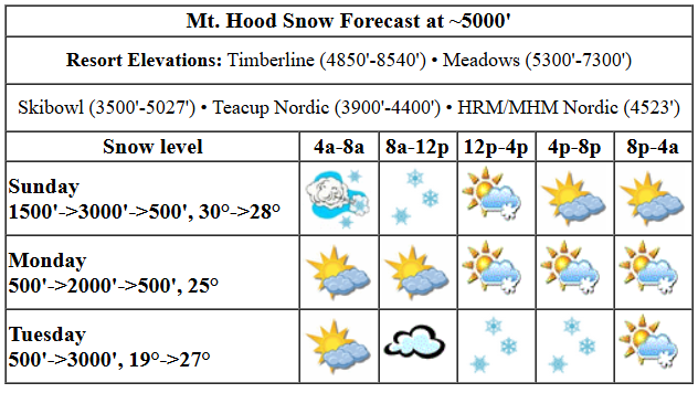
Sunday’s a pow day. The snow level will be 1500′ in the morning, 3000′ in the afternoon, and the freezing level will be less than 1000′ under partly cloudy sky tonight. Temps at 5000′ will be near 30F early and will fall to the mid-upper 20s. Snowfall pretty much wraps up before lifts open for the day; we could pick up maybe an inch this morning and a trace tonight, but hey, there’s 10” of new overnight and 19” in the last 24 hours! Today’s wind will be WNW 40mph early, but should drop by opening to WNW 20-30mph. Wind this afternoon falls to W 15mph, and it drops below 10mph tonight.
Monday starts high overcast and turns partly cloudy. Terrain-driven snowfall is possible overnight. The snow level will be less than 1000′ in the morning, 2000′ in the afternoon, and 500-1000′ after midnight. Most of the day will be dry. In the afternoon, we could see a trace of snow. Overnight, 0.3” to 0.5” water equivalent (WE) is forecast for 3-5” of cold, dry powder. Temps start the day in the low 20s and rise just a bit thanks to sun in the afternoon. Wind: Light NW early building to NW 25-35 in the afternoon and turning to W 30 overnight.
Light snowfall is forecast Tuesday daytime before tapering off overnight. The snow level will be around 1000′ in the morning, 2000′ in the afternoon, and 3000′ after midnight. Just an inch or two of snow is forecast during the day. Overnight: a trace. Wind will be W 30 in the morning, WSW 15 in the afternoon, and S 5-15 after midnight.
extended mt hood weather forecast
Wednesday daytime looks dry and high overcast with temps rising above freezing. Snow returns Wednesday night and sticks around, on-and-off, through at least Friday. There’s some hint of warming next weekend, but there are also signs of dumping snow. So, let’s leave it for now and see how things sort out over the next few days. Enjoy the pow day!
Was that helpful? I knew it was! Guess what? All of this crucial work – from your personal wind and snow reports to the invaluable TATAS updates – is made possible by my relentless efforts. Maintaining this labor of love isn’t easy. Each daily forecast takes hours. Website hosting, weather model access, and back-end admin work takes time and money. That’s where you come in.
YOUR CONTRIBUTION MAKES A DIFFERENCE
- SUPPORT ACCURATE, HYPER-LOCAL WEATHER FORECASTING
- ENABLE ACCESS FOR ALL, EVEN THOSE WITH LESS MEANS
- SUPPORT A COOL HUMAN WHO WORKS HARD SO YOU CAN PLAY
Take a moment to click one of the buttons below. Donate $19.99 or more (how much does this forecast enhance your life?) and get the email in your inbox. Whether it’s a renewing subscription (auto-renew) or a one-time donation, every contribution makes a real difference. Help me keep this labor of love alive, so we can all continue playing, commuting, and living in the Gorge with peace of mind and the best weather forecasts possible. Thank you!


Hood River, Oregon 97031


GORGE WIND FORECAST

Hi friends! Mother Nature continues to assert herself with active weather over the next week or so. Best chances for wind are Monday (decent setup) and Thursday (lesser setup). Sunday starts with pressures of 29.60/29.53/29.47 for gradients of 0.07/0.06. Those pressures will drop. Models hint at an early burst of 16-19ish from Stevenson to Swell, but it may be done already. For the rest of the day, areas west of the Dalles stay under 10mph. From Avery to Boardman, we could see gusty 19-22 this morning with gusty 15-18 this afternoon. Take off 20-30% for those sensors reading being high compared to Swell, and you have… “not much”. River flow over the last 24 hours was 99-183kcfs, river temp is 43.30F, and high temp forecast is 47F under cloudy sky.
On Monday, a weak low moves inland along the ORCA border, and transient high pressure builds offshore. We should see a burst of 21-24 from Stevenson to Rufus late morning as this low moves inland. The west side, Stevenson to Doug’s, drops to 15-18 in the afternoon, and Avery to Arlington slowly rises to 25-28. High temp: 49F with clouds in the morning and mostly clear sky in the afternoon. Tuesday starts with 7-10 in the west and 14-17 from Lyle to Boardman. The wind fades as the day progresses. High temp: 50F with intermittent showers and partly cloudy sky. Wednesday: widespread moderate easterlies. Thursday: westerlies are possible as a front swings through, but this is far from an ideal setup. Chances are it’ll be focused on the eastern Gorge and marginal. Hope to see you out there Monday!
BARE BONES HOOD RIVER WEATHER FORECAST
Clouds stick around all day. Temps start in the upper 30s and rise to the upper 40s. Light to moderate westerlies. 10% chance of rainbows. Monday will be cloudy in the morning and sunny in the afternoon with a few showers overnight. Temps start in the low-mid 30s and rise to the upper 40s. Moderate to moderately strong westerlies. 3% chance of rainbows. Tuesday will be intermittently showery. Temps start in the mid 30s and rise to 50 or so. Moderate westerlies early. Light westerlies later. 99% chance of rainbows.
TEMIRA’S AWESOME TRAVEL ADVISORY SERVICE
HYPERLOCAL WEATHER FORECAST FOR THE COLUMBIA GORGE
THE DALLES, HOOD RIVER, WHITE SALMON, TROUT LAKE, STEVENSON, CASCADE LOCKS, PARKDALE, ODELL, HUSUM, BZ, MILL A, WILLARD, GOLDENDALE, RUFUS, ARLINGTON, boardman
Good morning, neighbors! We did not reach a surplus for the water year with this last weather system. Maybe next weekend if the GFS pans out with an atmospheric river…
sunday
It’s Sunday today, and it’ll be dry and cloudy unless you drive south until you encounter rain. If you do, it’ll be wet. Duh. Temps max out in the upper 40s in the lowlands. The snow level starts around 1500′ (it was sub-freezing in Parkdale early) and rises to 3000′ this afternoon. Overnight, we’ll have partly cloudy sky, 850mb (5000′ ish) temps at -4C, and a shot at frost all the way down to the Nch’i Wana. Today’s wind will be 10-13mph west of The Dalles and 15-18mph east of The Dalles to Boardman. The day starts windy in the hills and turns much less windy by tonight.
monday
Clouds on the west side and partly cloudy sky on the east side kick off a frosty (away from the river, anyway) Monday. By afternoon, we’ll be mostly clear, 50 degrees, and breezy in the lowlands. Westerlies will rise to 20-25mph from Stevenson to Rufus in the morning. Afternoon: 15-20mph west of The Dalles and 20-30mph to the east. Overnight, a few showers swing through and drop an inch or so of snow in the Parkdale, York Hill, and Underwood zones.
tuesday
Intermittent light rain showers are forecast as far east as Hood River all day Tuesday with showers as far east as The Dalles early and late. Rainbow chances are near 100%. Max temps: 50F. Wind will be W 15mph in the morning and under 10mph in the afternoon.
wednesday and beyond
Wednesday daytime looks dry. Rain returns overnight. That’s just the start of the next rainy period. It continues through the 22nd or 23rd, after which the Euro insists we’ll have three days of 65-70 degree weather. Prior to that, it’s possible we’ll have quite the atmospheric river event next weekend. The GFS is pretty amped up about that. Euro: not so much. Safe travels. -TATAS
HEY! DON’T STOP READING! Is this community-focused forecast helpful to you? It sure is! It takes me a couple hours a day to write. Please join your friends and neighbors in contributing to keep it going. Venmo: @thegorgeismygym PayPal: twomirrors@gmail.com USPS: Temira / PO Box 841 / Hood River, Oregon 97031 You can test out the forecast subscription for a few days for free by signing up below. Easy! Do it!
