

MT HOOD WEATHER FORECAST
Hey skiers and snowboarders! Spring is definitely in charge now – we’ll see a few days of light to moderate snowfall, a couple days of unstable weather with showers and/or thundershowers possible, and then warming weather starting later this week. Reminder: I’ll be taking off for a month starting April 1st, which means I’ll be super excited to see you all and super excited to resume forecasting when I return early in May. Let’s take a look at today’s Mt Hood weather, shall we?
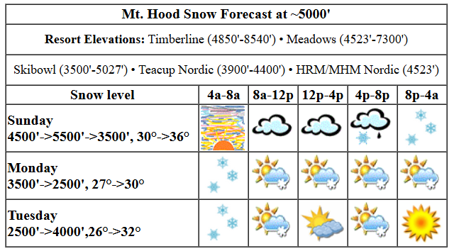
today’s mt hood weather forecast
Sunday kicks off high overcast. Those clouds deepen as the day progresses, and rain or mixed precip arrives mid-afternoon. The snow level will be 4500′ this morning, 5500′ this afternoon, 4500′ in the evening, and 3500′ overnight. Temps at 5000′ start around 30F, rise to 36F this afternoon, and fall to 27F overnight. The bulk of the precip, about 0.4” WE, arrives at the leading edge of this system and will be either mixed precip or very wet snow. Let’s call it 1-3” prior to 5pm at 5000′. Overnight, another 0.1” WE is forecast to fall as snow, but just an inch is expected. Wind today will be light easterly early rising to E 30 in the afternoon, which is right on the edge of what would cause impacts on Timberline’s lifts. Meadows does better than T-Line in easterlies. Wind drops overnight and lands at S 10-15 after midnight.
monday mt hood weather forecast
Monday brings light snow. The snow level will be 3500′ all day and will fall to 2000-2500′ after midnight. Temps start around 27F, rise to 30F, and fall 26F or so overnight. About 0.3” WE is forecast during the day for about 3” of moderate density snow. Overnight, another 0.1” to 0.2” WE is forecast for another 1-2”. It’s worth noting that models are probably overestimating snowfall in the evening as what it’s predicting is related to instability. Wind on Monday will be S 10-15 in the morning, SW 15-20 in the afternoon, and SE 10 overnight.
tuesday mt hood weather forecast
Light snowfall Tuesday morning gives way to partly cloudy sky with instability and random flurries in the afternoon. The snow level will be 2000′ in the morning, 4000′ in the evening, and 1000′ overnight. Wind: SE 10 in the morning, NW 15-20 in the afternoon, and W 25 after midnight.
extended mt hood weather forecast
Wednesday and Thursday both look clear and sunny with 850mb (5000′) temps forecast to stay a bit below freezing. Remember that the sun is quite strong this time of year and will warm the snow despite the temps being chilly. Warmer weather is forecast as we move into the end of next week and the weekend – spring skiing is on tap for sure. Tomorrow will be my last forecast until I return. I hope you have a fabulous April!
Was that helpful? I knew it was! Guess what? All of this crucial work – from your personal wind and snow reports to the invaluable TATAS updates – is made possible by my relentless efforts. Maintaining this labor of love isn’t easy. Each daily forecast takes hours. Website hosting, weather model access, and back-end admin work takes time and money. That’s where you come in.
YOUR CONTRIBUTION MAKES A DIFFERENCE
- SUPPORT ACCURATE, HYPER-LOCAL WEATHER FORECASTING
- ENABLE ACCESS FOR ALL, EVEN THOSE WITH LESS MEANS
- SUPPORT A COOL HUMAN WHO WORKS HARD SO YOU CAN PLAY
Take a moment to click one of the buttons below. Donate $19.99 or more (how much does this forecast enhance your life?) and get the email in your inbox. Whether it’s a renewing subscription (auto-renew) or a one-time donation, every contribution makes a real difference. Help me keep this labor of love alive, so we can all continue playing, commuting, and living in the Gorge with peace of mind and the best weather forecasts possible. Thank you!


Hood River, Oregon 97031


GORGE WIND FORECAST

Hi friends! Just a few more days until I take off for a month, and Ma Nature is offering up some wind in that time period. Sunday brings easterlies as a low spins offshore. Stevenson starts the day at 20-25mph, and Iwash (Rooster) starts at 30-35mph. By mid-morning, we should have 25-30mph at Stevenson and 20-25mph at Iwash. Afternoon wind falls to 20-25 at Stevenson and 25mph at Iwash and rises to 15-25mph (lighter near Hood River, stronger to the east) from Hood River east to Arlington. In the evening, Iwash falls to 15mph, Stevenson to 20mph, and areas east of Hood River fade to 15mph. River flow over the last 24 hours has been cranking: 234-247kcfs (Rufus is out for paddling for now, but fine for other sports0, river temp is 47.3F, and high temp forecast is 58F with increasingly cloudy, then rainy weather.
Monday sees a front swing through. The day starts calm. By late morning, we’ll have 10-13 from Stevenson to Hood River, 5-10 or less from Mosier to Doug’s, and 18-22 from Avery to Arlington. Afternoon gives us a shot at 14-17 from Stevenson to Doug’s with the eastern Gorge holding at 18-22. Add in instability, and you can expect the wind to be especially gusty and unreliable. High temp: 54F with rain in the morning and showers in the afternoon. Tuesday sees a low move inland and high pressure build behind it. Reality will likely exceed the models on this one. As of now, models have calm wind to start and 19-23 from Stevenson to Avery from mid-afternoon on. High temp: 57F with another round of afternoon instability and showers. Fingers crossed! There’s another shot at slightly lesser westerlies on Wednesday. Y’all have fun. I’ll be missing you and the river while I’m gone in April!
BARE BONES HOOD RIVER WEATHER FORECAST
High clouds this morning and rain after 2pm. Temps start in the upper 30s and rise to the upper 50s. Light easterlies early. Moderate easterlies later. 18% chance of rainbows. Monday will be drizzly in the morning and showery in the afternoon. Temps start in the upper 30s and rise to the mid 50s. Calm wind early. Moderate westerlies later. 99% chance of rainbows. Slight chance of thunder. Tuesday will be dry in the morning and showery with chance of thunder in the afternoon. Temps start in the mid to upper 30s and rise to the mid to upper 50s. Calm wind early. Moderately strong westerlies in the afternoon. 91% chance of rainbows.
TEMIRA’S AWESOME TRAVEL ADVISORY SERVICE
HYPERLOCAL WEATHER FORECAST FOR THE COLUMBIA GORGE
THE DALLES, HOOD RIVER, WHITE SALMON, TROUT LAKE, STEVENSON, CASCADE LOCKS, PARKDALE, ODELL, HUSUM, BZ, MILL A, WILLARD, GOLDENDALE, RUFUS, ARLINGTON, boardman
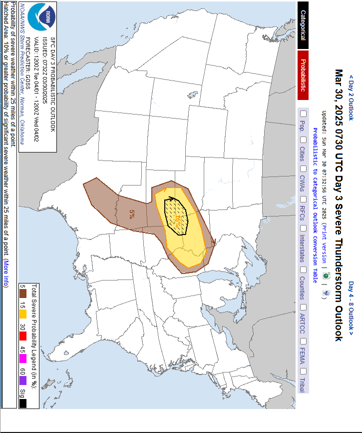
Good morning, neighbors! Say bye-bye to the dry weather. Soaking rain returns this afternoon, and then we’ll be in a showery pattern for a couple of days. SPC gives us a chance of thunderstorms the next couple of days. Nothing too exciting, but we could see a little thunder, some heavy downpours, and perhaps some small hail. Nothing like what’s happening in the Midwest, Oklahoma, and Texas Tuesday when Mother Nature grows some balls and penetrates Texas with a tumbling turtleneck dinosaur. (The image works a lot better if you turn it 90 degrees. So I did. Creative license…)
glenwood
Up in Glenwood this morning, where the sky was clear long enough for radiational cooling to kick in, it’s 28 degrees with a dewpoint of 24F. Brrr. Find your puffy coat, Glenwood people!
today (it’s sunday, yo)
The rest of us languish under cloudy sky today. Pouring rain arrives around 2pm and extends all the way to Amayah’s (the location formerly known as Biggs) and also into south Wasco and Sherman counties. After 5pm, that rain pushes all the way east past Boardman. This moisture is related to an offshore low, and that low is strong enough to drive easterlies through the entire Gorge. You’ll find 30mph or so near Stevenson and Iwash (p*nis) Rock this morning. Easterlies build to 15-25mph near The Dalles this afternoon with 15mph to the east and 15mph between Viento and Lyle. High temp today will be around 58F. We can’t rule out a thunderstorm or two this afternoon. Nor can we rule them in. One last thing: there’s a bike race, the Rowena Roubaix, happening today on the old 30 through Rowena (and other roads). Avoid the route.
monday’s gorge weather
On to Monday…. rain in the morning west of Mosier, showers and rain on-and-off to Boardman in the afternoon as instability kicks in and kicks off showers, downpours, and perhaps a thunderstorm. Wind will be calm to start and west 15-25mph in the afternoon. High temp: 54F with plenty of rainbows.
tuesday’s gorge weather
Tuesday will be calm and dry and partly cloudy to start with afternoon showers thanks to instability. That’s the day Texas gets fucked (finally!). Avoid Texas that day, and skip Oklahoma too. Showers and perhaps a thunderstorm are possible in the afternoon. Temps rise to the upper 50s, and the wind picks up to 20-25mph from Stevenson to Amayah’s, the location formerly known as Biggs. On that day, I’ll be on an airplane. Hopefully the gutted Federal Aviation Administration can get me to my destination safely.
extended gorge weather forecast
Looking deeper into next week… sunny, warm, dry weather is forecast for a few days. All the trees will look at the sun, look at you, and start putting out leaves. It’s going to be a beautiful couple of weeks in the Gorge as everything leafs out and blossoms pop open on the earliest fruit trees. Oh happy times! Safe travels. -TATAS
