

MT HOOD SNOW FORECAST

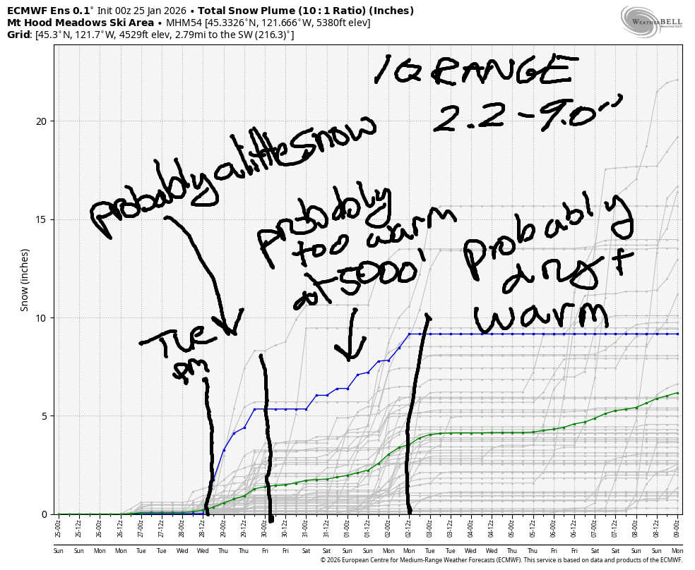
Hey skiers and snowboarders! The miracle of long-lasting snow continues, and we should be thankful for that. Very little snow is forecast in the next couple of weeks – the intraquartile range between now and the morning of 2/8 sits at 2.2-9.0” snowfall. In that same time period, models are calling for 1-3” total precipitation – most of the time, the weather looks too warm for that to fall as snow. Eek. Get out there and enjoy the snow we’ve got – let go of the powder dream and embrace the carving dream!
Short term Mt Hood snow forecast
Sunday brings a day of high clouds and filtered sun. The free air freezing level will be around 7000′ early and will fall to around 6000′ later. No precip. Wind will be nearly calm early, W 15 in the afternoon, and WSW 20-25 after midnight.
Monday will be cloudy to start and partly cloudy to finish with high overcast sky overnight. The free air freezing level (FAF) will be 6500′ in the morning, 5000′ in the afternoon, and 6000′ after midnight. Wind will be WSW 20-25 in the morning, W 25 in the afternoon, and S 10 overnight.
Extended Mt Hood Snow Forecast
Tuesday starts high cloudy. Models give us at least a chance of some precipitation in the evening. Forecast temps at 850mb (5000′) range from 0C to +2C, so it’s possible we”ll see some wet snow at 5000′. It’s unclear how much precip we’ll see – models have anything from a trace to 0.5” water equivalent. Given how dry the air is right now, I’d lean towards the lower half of that range. Anyway, the snow level will be 6000′ all day and 4000′ after midnight. Wind: S 10 in the morning becoming SSW 15-25 in the afternoon and holding overnight.
Models suggest that Wednesday will be dry and cooler with the free air freezing level around 5000′ and SW wind at 15-25mph. It’s possible we could see another round of precip on Thursday, but models are keeping temps at 5000′ above freezing. Looking deeper into the future, both the ECMWF and the GFS hold temps at 5000′ above freezing for basically the entirety of the next two weeks. If this continues, we are almost certainly going to be in lowest-snowpack-ever territory. We’re not quite there yet, but we’re close. So… get out and enjoy what we’ve got!
Was that helpful? I knew it was! Guess what? All of this crucial work – from your personal wind and snow reports to the invaluable TATAS updates – is made possible by my relentless efforts. Maintaining this labor of love isn’t easy. Each daily forecast takes hours. Website hosting, weather model access, and back-end admin work takes time and money. That’s where you come in.
YOUR CONTRIBUTION MAKES A DIFFERENCE
- SUPPORT ACCURATE, HYPER-LOCAL WEATHER FORECASTING
- ENABLE ACCESS FOR ALL, EVEN THOSE WITH LESS MEANS
- SUPPORT A COOL HUMAN WHO WORKS HARD SO YOU CAN PLAY
Take a moment to click one of the buttons below. Donate $19.99 or more (how much does this forecast enhance your life?) and get the email in your inbox. Whether it’s a renewing subscription (auto-renew) or a one-time donation, every contribution makes a real difference. Help me keep this labor of love alive, so we can all continue playing, commuting, and living in the Gorge with peace of mind and the best weather forecasts possible. Thank you!


Hood River, Oregon 97031


GORGE WIND FORECAST
If you’re still seeing yesterday’s and it’s after 9am, try opening this in an incognito window

SHORT-TERM gorge wind forecast
Hi friends. Easterlies continue in some form through at least Wednesday. No sign of a west wind day in the forecast. Sunday started with pressures of 30.23/30.36/30.37. East wind at dawn was 42mph at Iwash (Rooster), 25mph at Stevenson, and 20mph at Viento. Easterlies rise to 50mph at Iwash and 35mph at Stevenson midday before dropping to 25-30mph at Stevenson and 35mph at Iwash. River flow over the last 24 hours was 187-214kcfs, river temps is 41.5F, and high temp forecast is 37F with high clouds.
RIVER FLOW FOR SITES BETWEEN AVERY (EAST OF THE DALLES) AND RUFUS: CLICK HERE FOR JOHN DAY DAM FLOW.
RIVER FLOW FOR SITES BETWEEN STEVENSON AND DOUG’S BEACH (WEST OF THE DALLES): CLICK HERE FOR THE DALLES DAM FLOW

LONGER-TERM gorge wind forecast
Monday starts with 20-25mph at Stevenson and 30-35mph at Iwash. Afternoon wind drops to 15mph at Stevenson and 10mph at Iwash. High temp: 44F under cloudy sky. Tuesday looks a little strong: 40mph at Iwash and 30mph at Stevenson, fading about 5mph in the afternoon. High temp: 41F under high clouds and filtered sun.
Easterlies continue on Wednesday, but they’re going to be lighter. Expect them to top out around 20-25mph. Thursday looks even lighter. I’ll leave it there for now. If you’re heading out, dress warmly, have an emergency plan, and keep an eye on your buddies!
BARE BONES HOOD RIVER WEATHER FORECAST
High overcast today. Temps start in the low 20s and rise to the mid to upper 30s. Light easterlies. No rainbows. Go Hawks! Monday will be cloudy. Temps start in the upper 20s and rise to the mid 40s. Light easterlies then calm. No rainbows. Tuesday will be cloudy. We could see a little rain overnight, but it’s a big maybe. Temps start in the low 30s and rise to the low 40s. Light easterlies. No rainbows.
TEMIRA’S AWESOME TRAVEL ADVISORY SERVICE
HYPERLOCAL WEATHER FORECAST FOR THE COLUMBIA GORGE
THE DALLES, HOOD RIVER, WHITE SALMON, TROUT LAKE, STEVENSON, CASCADE LOCKS, PARKDALE, ODELL, HUSUM, BZ, MILL A, WILLARD, GOLDENDALE, RUFUS, ARLINGTON, boardman
Good morning, neighbors! Go Seahawks! Go Glenwood! Go Mother Nature! Goodness gracious… there is seriously very little to talk about in the forecast for the next couple of weeks. We’re definitely backing ourselves into a corner with the lack of precipitation…
Glenwood this morning
Let’s celebrate something. Let’s celebrate Glenwood, where temps bottomed out at 11F this morning. Everyone in Glenwood is celebrating this by playing switch today: the bottoms are being tops, and the tops are bottoming. This involves a lot of bare buttocks, but everyone’s okay with that despite the low temps because “buttocks” is such a fun word to say. Elsewhere in the Gorge this morning, people are retaining their usual roles of top/bottom/Ace. Dufur area temps were in the teens, and the Upper Valley was flirting with the low 20s, which is totally okay, because that’s legal.
Today’s Gorge weather forecast
For the rest of today, we’ll hang with high clouds. Temps eventually rise to the mid or upper 30s in the lowlands. East wind picks up to 50mph near Iwash (where are the other 99% of the files?) Rock and 35mph at Stevenson before dropping to 30-35mph both locations in the afternoon. Wind will be light east of Viento.
Monday’s Gorge weather forecast
Clouds stick around into Monday, which gives us a slightly warmer start – mid to upper 20s depending on your location. NWS says we’ll reach the mid 40s in the lowlands tomorrow, but that seems unlikely given cloud cover and east wind. How does upper 30s sound? Let’s go with it. Wind at Iwash will be 30-35mph in the morning and 10mph in the afternoon. Stevenson: 20-25mph fading to 15mph, which people in Stevenson and Cascade Locks will be delighted about after weeks (well, it seems like weeks, anyway) of easterlies.
Extended Gorge weather forecast
On Tuesday morning, we’ll have a combo of Nothing near the river and high clouds all across the land. Nothing goes away, but high clouds stick around. Morning temps will be mid 20s to low 30s. Afternoon: upper 30s to right around 40F. East wind returns. Sorry, Cascade Locks: 25-30mph for you, and 30-40mph for Iwash.
It’s possible the western half of the Gorge could see a little precipitation overnight Tuesday into Wednesday. It might even be snow despite marginal temps thanks to evaporative cooling. I can’t recommend you get excited about the possibility of snowfall because 1) temps are marginal, and 2) I suspect the quantity of precip in the forecast will decrease as we approach Tuesday. Precip is currently scared of the Pacific Northwest. It doesn’t want to be the first to arrive at the party. Nobody does. So none of the precip is walking in the door. Alas. My fingers are crossed that some precip grows a pair (of whatevers) and enters our house soon.
Speaking of entering the house… remember that !CE cannot enter your house without a signed JUDICIAL WARRANT. An administrative warrant is not enough. Exercise your 4th Amendment rights and say, “Go away!” You can also exercise the 5th amendment right of refusing to say anything to them at all. Safe travels. -TATAS
HEY! DON’T STOP READING! Is this community-focused forecast helpful to you? It sure is! It takes me a couple hours a day to write. Please join your friends and neighbors in contributing to keep it going. Venmo: @thegorgeismygym PayPal: twomirrors@gmail.com USPS: Temira / PO Box 841 / Hood River, Oregon 97031 You can test out the forecast subscription for a few days for free by signing up below. Easy! Do it!
JONES BEACH, SAUVIE ISLAND, & COAST FORECAST
ON WINTER VACATION UNLESS DESPERATELY NEEDED.
