

MT HOOD SNOW FORECAST

Hey skiers and snowboarders! Snow, albeit wet snow, but honest-to-goodness snow is falling on the slopes of Mt Hood this morning. Hooray! We’ll pick up an inch or two today, and then we plunge right back into another super-strong ridge that brings sunshine and warm weather all week. The Euro remains insistent that we’ll pick up significant snowfall starting around the 8th. I have all my fingers and toes crossed, and you should too!
Short term Mt Hood snow forecast
Sunday sees the snow level around 5000′ early, 4000′ later, and 3500′ overnight. We’ll see a few hours of light snowfall this morning with 0.1” to 0.2” water equivalent (WE). This gives us 1-2” dense snow at 5000′ and, if we’re really lucky, an inch at 4000′. By early afternoon, the sky will be partly cloudy or maybe even clear. High clouds move in overnight. Wind today will be SW 20-30 early, WSW 30 midday, SW 20-30 in the afternoon, and light SW overnight. Snow surface is currently frozen granular. It was hard and fast early yesterday thanks to radiational cooling, but it softened to spring slush very quickly. Not sure how that’ll look today given the snow falling, but that’s what I’ve got for you!
Monday starts with high clouds, adds some mid-level clouds, and clears overnight as a beastly ridge builds in. The free air freezing level rises from 3500′ in the morning to 7000′ in the afternoon to 9500′ overnight. Wind will be light SW in the morning, W 20 in the afternoon, and SE 10 after midnight.
Extended Mt Hood Snow Forecast
For the rest of the week, models have sunny, warm weather with 850mb temps (~5000′) maxing out at 50-55F each day. This is going to have a detrimental impact on the snowpack – it’s already saturated, and it’s melting fast. Fortunately…
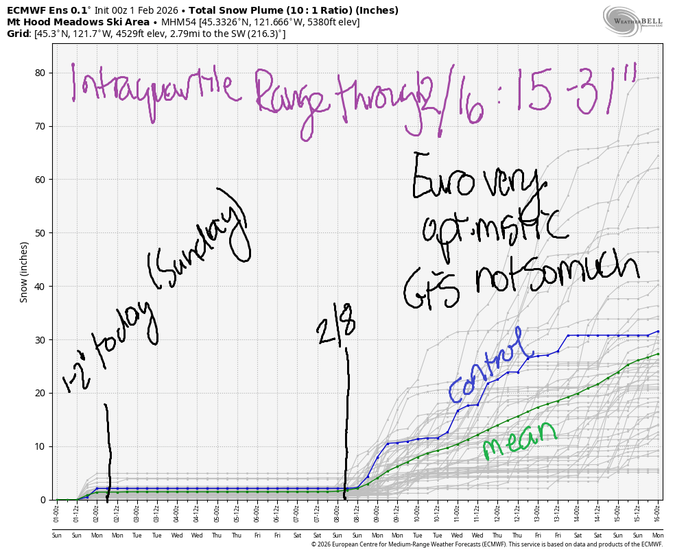
The Euro (and at least some members of the GFS ensemble) is very optimistic that we’ll pick up significant snow starting around the 8th or 9th of February. The intraquartile range through February 16th is 15-31” of new snow. I’m just going to sit right here and hold out hope that’s right. Or that we beat that 75th percentile prediction and soar up to the 90th percentile which calls for 50” of snow by the 16th. In the meantime, get it while you can!
Was that helpful? I knew it was! Guess what? All of this crucial work – from your personal wind and snow reports to the invaluable TATAS updates – is made possible by my relentless efforts. Maintaining this labor of love isn’t easy. Each daily forecast takes hours. Website hosting, weather model access, and back-end admin work takes time and money. That’s where you come in.
YOUR CONTRIBUTION MAKES A DIFFERENCE
- SUPPORT ACCURATE, HYPER-LOCAL WEATHER FORECASTING
- ENABLE ACCESS FOR ALL, EVEN THOSE WITH LESS MEANS
- SUPPORT A COOL HUMAN WHO WORKS HARD SO YOU CAN PLAY
Take a moment to click one of the buttons below. Donate $19.99 or more (how much does this forecast enhance your life?) and get the email in your inbox. Whether it’s a renewing subscription (auto-renew) or a one-time donation, every contribution makes a real difference. Help me keep this labor of love alive, so we can all continue playing, commuting, and living in the Gorge with peace of mind and the best weather forecasts possible. Thank you!


Hood River, Oregon 97031


GORGE WIND FORECAST
If you’re still seeing yesterday’s and it’s after 9am, try opening this in an incognito window
SHORT-TERM gorge wind forecast
Hi friends! Not much happening until Wednesday when a(nother) ridge of high pressure builds in and gives us a shot at strong easterlies. Until then…. Sunday started with near 30mph at Iwash (Rooster) Rock, but the wind dropped below 10mph as the rain arrived.
We’ll see calm wind until early afternoon when the passing cold front turns the wind westerly… barely. Expect 10mph west of The Dalles with perhaps 15-18mph from Maryhill to Arlington or Threemile this afternoon. River flow website isn’t working this morning. River temp is 40.6F, and high temp forecast is 52F with drizzle in the morning and partly cloudy sky in the afternoon.
RIVER FLOW FOR SITES BETWEEN AVERY (EAST OF THE DALLES) AND RUFUS: CLICK HERE FOR JOHN DAY DAM FLOW.
RIVER FLOW FOR SITES BETWEEN STEVENSON AND DOUG’S BEACH (WEST OF THE DALLES): CLICK HERE FOR THE DALLES DAM FLOW

LONGER-TERM gorge wind forecast
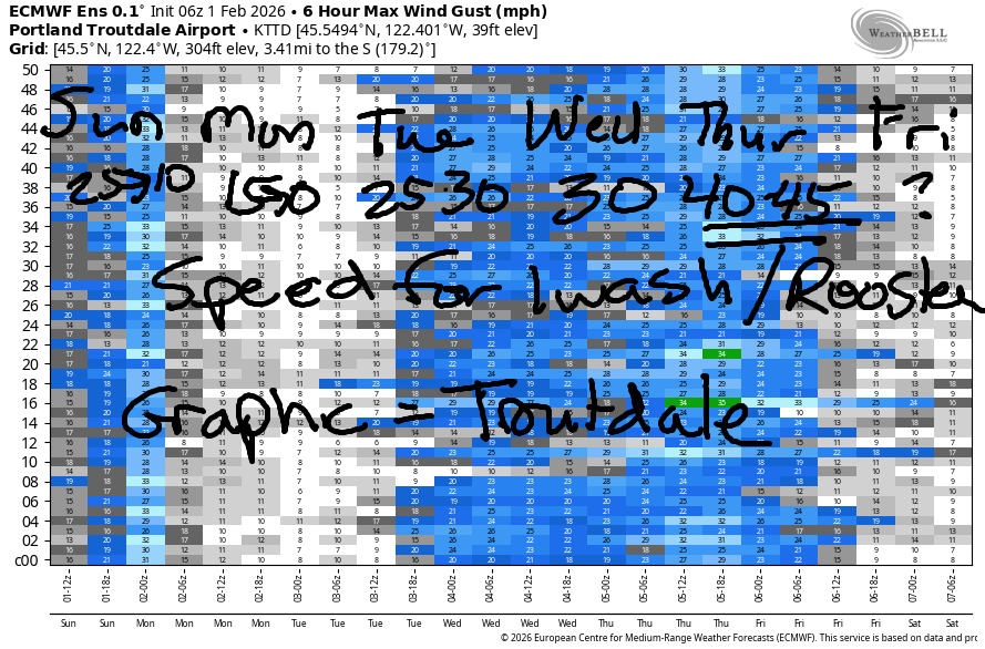
Monday brings easterlies at 15mph at Iwash and Stevenson in the morning and calm wind in the afternoon. High temp: 50F with mostly cloudy sky and no precipitation. Tuesday sees ridging rebuilding over the Pacific Northwest. This gives us easterlies at 25-30mph at both Stevenson and Rooster Rock all day long.
Stronger easterlies are forecast on Wednesday, perhaps 30-35mph with sunshine and high temps in the low 50s. Thursday brings east wind at 40-45mph with plenty of sunshine and high temps in the low 50s. Models suggest less wind on Friday, but the sunshine and mild temps are likely to remain. If you’re heading out, dress warmly, have an emergency plan, and keep an eye on your buddies!
BARE BONES HOOD RIVER WEATHER FORECAST
Rain this morning. Partly cloudy this afternoon. Temps start in the low 40s and rise to the low 50s. Light easterlies early. Light westerlies later. 98% chance of rainbows. Monday will be cloudy. Temp start in the upper 30s and rise to 50 or so. Calm wind. No rainbows. Tuesday will be Nothing then partly cloudy. Temps start in the upper 30s and rise to the low 50s. Light easterlies. No rainbows.
TEMIRA’S AWESOME TRAVEL ADVISORY SERVICE
HYPERLOCAL WEATHER FORECAST FOR THE COLUMBIA GORGE
THE DALLES, HOOD RIVER, WHITE SALMON, TROUT LAKE, STEVENSON, CASCADE LOCKS, PARKDALE, ODELL, HUSUM, BZ, MILL A, WILLARD, GOLDENDALE, RUFUS, ARLINGTON, boardman

Good morning, neighbors! IT’S RAINING! Well, it’s raining at my house, anyway, and maybe it’s raining at yours. We will see drizzle make it as far east as Arlington today. If you love rain, make sure you love on it today. Next chance of any precipitation after today isn’t until next weekend. We’ll be high, dry, and inverted all week long.
Valuable advice for gardeners inhabiting neighboring areas
I received a report yesterday of peas spontaneously germinating and growing in High Prairie. We’re not supposed to plant peas until PRESIDENTS (not kings) DAY, which is 2/16 this year, but F it. Go ahead and sprout some peas indoors and toss them in the ground. This winter is messed up. Might as well mess with the garden schedule too.
Glenwood this morning
Checking in with Glenwood… it’s 36F there. Since there’s no snow on Defiance, everyone decided to plant tomatoes. Maybe don’t get that aggressive – Mt. Defiance is likely to regain its blanket of snow starting sometime late next weekend or early next week.
Today’s chance to exercise your first amendment rights
Today’s demonstration: 3-4pm at Mercado Guadalajara in support of the local immigrant and BIPOC community. Bring signs, a heart full of love, and good cheer! There are also overpass demonstrations in Mosier and The Dalles 3-4pm.
Today’s Gorge weather forecast
Today… drizzle as far east as Hood River through early afternoon then drizzle from The Dalles to Arlington and also in South Wasco County mid-afternoon. Up to 0.3” rain is possible from Corbett to Cascade Locks, where the driving will be unpleasant for a few hours this morning due to heavy rain. A trace of rain falls in the desert. Up to 0.1” is possible in Hood River. Temps rise to the low 50s this afternoon as the wind switches to light westerly, 15mph or less. Combine the rain and the west wind for a 99% chance of rainbows. Snow level 4000′.
Monday’s Gorge weather forecast
Monday will be mostly cloudy, but it’ll be dry. A partial Nothing near the river in the morning could result in a little mist or fog for a few areas. Temps look to stay above freezing: mid to upper 30s for the morning. Afternoon: 50-53F with calm wind.
Extended Gorge weather forecast
Ridging takes over on Tuesday. This leads to east wind and somewhat inverted temps. Mornings: mid to upper 30s. Afternoons: low 50s. Head west to the Valley of Willies or the coast for 60 degrees and sunshine. Wow. This pattern sticks around through at least Thursday and quite possibly longer. East wind builds through Thursday. Iwash wind: 25-30mph Tuesday, 30-35mph Wednesday, and 40-45mph Thursday. Nothing gets a little deeper each day, and each day it gets a little more likely that it won’t burn off. As we move in to next weekend, we see the possibility of a return to wetter, cooler weather. Details are unclear, so I won’t speculate. One should not speculate. One should do their research and make informed decisions after reflecting on all available information. Safe travels. -TATAS
HEY! DON’T STOP READING! Is this community-focused forecast helpful to you? It sure is! It takes me a couple hours a day to write. Please join your friends and neighbors in contributing to keep it going. Venmo: @thegorgeismygym PayPal: twomirrors@gmail.com USPS: Temira / PO Box 841 / Hood River, Oregon 97031 You can test out the forecast subscription for a few days for free by signing up below. Easy! Do it!
JONES BEACH, SAUVIE ISLAND, & COAST FORECAST
ON WINTER VACATION UNLESS DESPERATELY NEEDED.
