

MT HOOD SNOW FORECAST

Hey skiers and snowboarders! Ski season is winding its way down, but that doesn’t mean you shouldn’t get in some laps! Get some laps before it’s gone! Meadows opened Superbowl for hiking yesterday. That’s always a treat and an excellent workout, as good as skate skiing and a worthy substitute now that Nordic is done for the year. Looking at the next week or so… we have warm weather for much of it, cooler weather (with good skiing likely) Tuesday and Wednesday, and warm weather again to close out the week. Uncertainty rises next weekend with some possibility for more active weather. Intraquartile range for snowfall through 4/20 is 3.0”-10.5”.
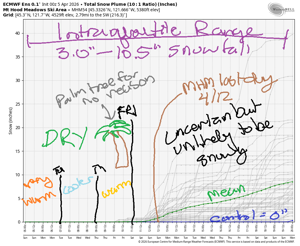
Short term Mt Hood snow forecast
No snow is in the cards on Sunday which will make it very easy to hunt down some Easter eggs! Warm weather is forecast with high clouds all day. The free air freezing level will be about 10,000′, and temps will rise to the mid 50s at 5000′. Wind: light and variable all day long. There was only a slight snap (freeze) to the snow overnight. It’s going to get warm and sticky fast today, so wax for it and hit the slopes early!
Mostly clear sky is forecast early on Monday. High clouds arrive in the afternoon. The free air freezing level hovers around 10,000′ all day with temps at 5000′ rising to the low 50s. Wind will be light SW early, W 20 in the afternoon, and WNW 35-40 overnight.
Extended Mt Hood Snow Forecast
Tuesday looks cooler and breezy. The free air freezing level will be around 4000′ all day under clear sky. Wind: WNW 35-40 early (a bit problematic), WNW 20-25 in the afternoon, and light/variable overnight. Snow conditions should be hard/fast granular early and excellent corn snow in the afternoon; temps only rise into the low-mid 30s. Another decent day is forecast on Wednesday as the freezing level rises from 4000′ to 6500′ during the day with max temps around 40F at 5000′. Overnight into Thursday, the freezing level climbs to 8500′, but you won’t be shredding then! Wind will be light/variable. Snow surface: frozen granular early and corn snow later.
Looking at the extended, less-certain forecast: Friday looks sunny and warmer. As we move into the weekend, forecast uncertainty increases. For you Meadows peeps: next weekend is the last of ski season, so make plans to be there! See you on the snow soon!
Was that helpful? I knew it was! Guess what? All of this crucial work – from your personal wind and snow reports to the invaluable TATAS updates – is made possible by my relentless efforts. Maintaining this labor of love isn’t easy. Each daily forecast takes hours. Website hosting, weather model access, and back-end admin work takes time and money. That’s where you come in.
YOUR CONTRIBUTION MAKES A DIFFERENCE
- SUPPORT ACCURATE, HYPER-LOCAL WEATHER FORECASTING
- ENABLE ACCESS FOR ALL, EVEN THOSE WITH LESS MEANS
- SUPPORT A COOL HUMAN WHO WORKS HARD SO YOU CAN PLAY
Take a moment to click one of the buttons below. Donate $19.99 or more (how much does this forecast enhance your life?) and get the email in your inbox. Whether it’s a renewing subscription (auto-renew) or a one-time donation, every contribution makes a real difference. Help me keep this labor of love alive, so we can all continue playing, commuting, and living in the Gorge with peace of mind and the best weather forecasts possible. Thank you!


Hood River, Oregon 97031


GORGE WIND FORECAST
If you’re still seeing yesterday’s and it’s after 9am, try opening this in an incognito window
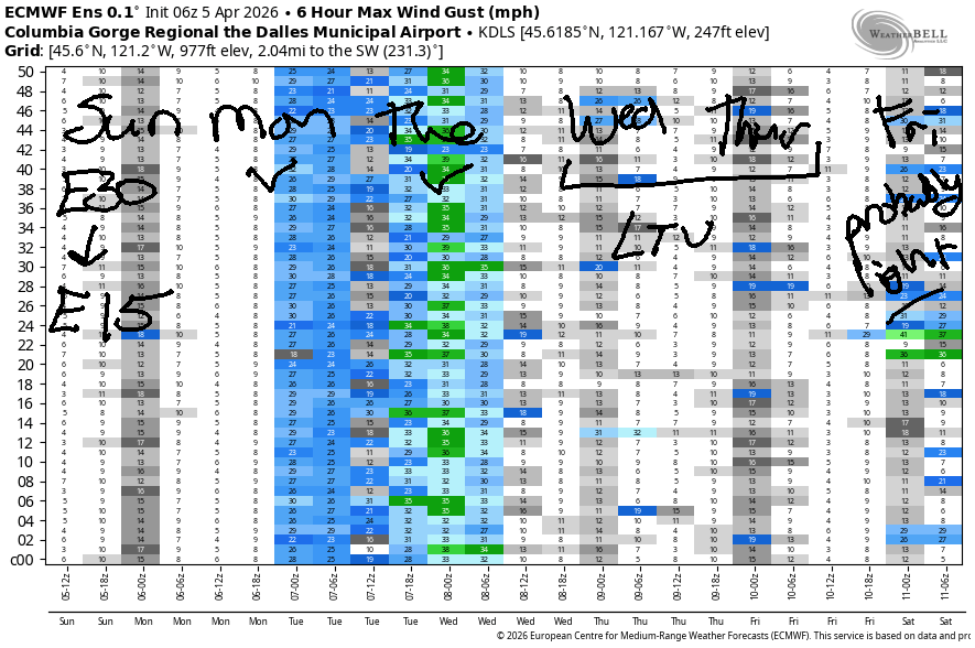
SHORT-TERM gorge wind forecast
Hi friends! East wind is on tap today (it’s Easter Sunday). Coming up tomorrow, west wind returns. Strongest wind will likely be after 5pm and into the night, but westerlies will persist on Tuesday. For the Wednesday-Friday window, models currently call for light/variable wind. Uncertainty rises to the I-Can’t-Predict zone starting next weekend, so that’s as far as we’ll take this forecast today.
Sunday started with pressures of 30.08/30.20/30.21 with easterlies at 38mph at Iwash/Rooster, 25mph at Stevenson, and 17mph at Viento. For the morning, the wind holds. By early afternoon, Viento falls to 15mph, and Stevenson/Iwash drop to 20-25mph. From mid-afternoon on, the wind will be 15mph or less. River flow over the last 24 hours was 195-219kcfs, river temp is 47.7F, and high temp forecast is 72F with high clouds.
RIVER FLOW FOR SITES BETWEEN AVERY (EAST OF THE DALLES) AND RUFUS: CLICK HERE FOR JOHN DAY DAM FLOW.
RIVER FLOW FOR SITES BETWEEN STEVENSON AND DOUG’S BEACH (WEST OF THE DALLES): CLICK HERE FOR THE DALLES DAM FLOW

LONGER-TERM gorge wind forecast
Monday starts dead calm. A cold front approaches from the NNW. This nudges the heat low to the east side and starts cooling off the west side. Impacts will be limited until late in the day. If we’re lucky, we’ll see 16-19mph from Stevenson to The Dalles with 11-14mph at Rufus by early afternoon. As the cooler air makes landfall after 5pm, wind strength rises to gusty 20-23mph from Stevenson to Mosier with 23-26mph from Lyle to Arlington. Even stronger wind is forecast overnight. *sigh* Why can’t it happen at 10am?!?!?!? High temp forecast is 76F in Hood River and near 80F out in the desert with increasing high clouds.
On Tuesday, offshore high pressure persists, but the desert heat low will be long gone. In other words, it’s not quite the cooldown you were looking for. That said, we will start the day with low clouds on the west side, and this will be enough for … 15-18mph from Stevenson to Mosier and 22-26mph from Lyle to Arlington for TJ’s Dawn Patrol. TJ owns dawn patrol, you know! Wind east of Rufus turns light quickly. For the rest of the day, we’ll have 18-21mph or so from Stevenson to Rufus. High temp: 61F for Hood River and upper 60s out in the desert.
Wednesday and Thursday currently look light and variable. Friday’s forecast is a bit more uncertain, but it’s likely to be in the “light wind” category. Beyond Friday, uncertainty rises. Ensembles like the possibility of west wind next weekend, but they’re far from clear on how strong it will be. I vote for “really strong”, but that’s always my vote. See you on the Nch’i Wana soon!

BARE BONES HOOD RIVER WEATHER FORECAST
High overcast sky this morning. Temps start in the low 40s and rise to the low 70s. Light easterlies. No rainbows. Monday will be mostly clear. Temp start in the upper 40s and rise to the mid 70s. Calm wind early. Moderate easterlies later. No rainbows. Tuesday will be cloudy then high overcast. Temps start in the mid 40s and rise to the low 60s. Moderate westerlies. No rainbows.
TEMIRA’S AWESOME TRAVEL ADVISORY SERVICE
HYPERLOCAL WEATHER FORECAST FOR THE COLUMBIA GORGE
THE DALLES, HOOD RIVER, WHITE SALMON, TROUT LAKE, STEVENSON, CASCADE LOCKS, PARKDALE, ODELL, HUSUM, BZ, MILL A, WILLARD, GOLDENDALE, RUFUS, ARLINGTON, boardman
Good morning, neighbors! Another damned fine day is on tap here in the Gorge – warm, partly cloudy, not too much wind… Blossoms are blooming. Now’s the time to get out and suffuse yourself in the beauty that is our home. If you can’t today, don’t worry – the weather looks conducive for outdoor shit all week!
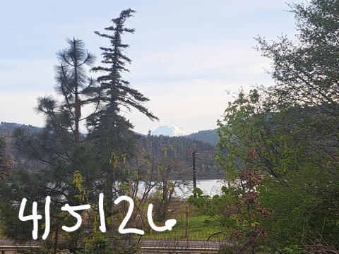
Glenwood this morning
Thanks to the high clouds, most places were spared a frosty morning. Glenwood: doing its thing with 32F. Trout Lake and Centerville were close seconds, but both were warmer than freezing. Middle Mountain was standing proud this morning with 48 degrees.
It’s only going to get warmer.
Duh.
Today’s Gorge weather forecast
Lowlands max out warmer than 70 degrees today: 72F to the west and 74F from The Dalles eastward. Morning wind will be E 30-40mph near Iwash (dick) Rock and 25mph near Stevenson. Afternoon wind fades to 15mph at those spots and picks up to E 5mph or so elsewhere.
Monday’s Gorge weather forecast
Temps stay quite warm tonight as at least some high clouds stick around for at least some of the night. Only Glenwood will be close to freezing on Monday morning. For the morning, we’ll have dead calm wind. Spray, baby, spray! Afternoon westerlies slowly build to 20mph west of Mosier and 25mph from Mosier eastward. Check out these high temps: 76F for Hood River (record: 79F), 79F for The Dalles, and 80F out in the desert where the watermelons are so, so, so excited to get growing when they see that kind of warmth.
Tuesday’s Gorge weather forecast
Overnight into Tuesday, we’re expecting strong wind, dropping dewpoints, and decreasing temps as a cold front swings through. All the action happens while most of us are sleeping. At sunrise, low clouds will be found west of Mosier with a few high clouds to the east. Wind at dawn will be 15-20mph west of Lyle and 25mph from Lyle to Arlington. Wind east of The Dalles backs off, but it persists at 15-20mph all day west of The Dalles. High temps will be down almost 15 degrees over Monday: 61F for the west, 64F for The Dalles, and 68F for the desert. The wind should protect us from frost Tuesday morning, but we’ll check in about that again tomorrow.
Extended Gorge weather forecast
A better chance of frost is in in the cards Wednesday morning as clear sky combines with 850mb temps at 0C. By afternoon. We’ll have sunshine, mid 60s, and light/variable wind. Thursday looks a bit warmer and also sunny and calm. By Friday, enough uncertainty inserts itself into the models that I’ll leave it there for now. Safe travels. -TATAS
Is this forecast helpful to you? It sure is! It takes me a couple hours a day to write. Please join your friends and neighbors in contributing to keep it going. Venmo: @thegorgeismygym PayPal: twomirrors@gmail.com USPS: Temira / PO Box 841 / Hood River, Oregon 97031 You can test out the forecast subscription for a few days for free by signing up below. Easy! Do it!
JONES BEACH, SAUVIE ISLAND, & COAST FORECAST
ON WINTER VACATION UNLESS DESPERATELY NEEDED.

Leave a Reply