

MT HOOD SNOW FORECAST

Hey skiers and snowboarders! Another windy day is on tap for Mt Hood, but at least this one won’t be summery-warm! By Sunday afternoon, temps will really be dropping. We’ll pick up a little snow through Tuesday night, and then we’re in dry, cold weather for a couple days. Sometime late Wednesday or early Thursday, things get very interesting on Mt. Hood. I’ll talk about that a bit later.
First things first: I want to express my deepest gratitude to all of you who donated to support Ski ALS and ALS Northwest. I’m so touched by your generosity and care for folks living with this illness. Thank you, thank you, thank you!
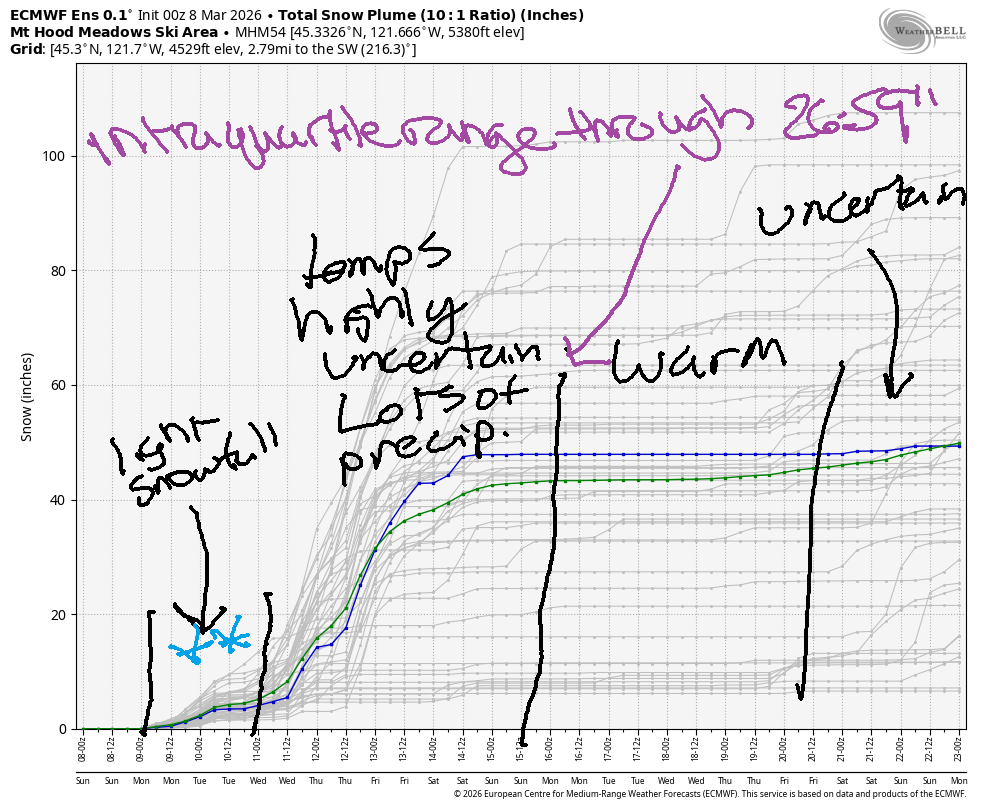
Short term Mt Hood snow forecast
Next up: today’s forecast. Overcast sky this morning gives way to drizzle midday and snow tonight. The snow level will be 11,000′ early, 5500′ in the afternoon, and all the way down to 1000′ overnight. We’re expecting about 0.2” rain during the day. That’s followed by 0.2” water equivalent (WE) of snow tonight for a couple inches of new. Wind will be disruptive early: WNW 40, enough to take some lifts offline. (Actually, everything at Meadows is on standby except Buttercup as of the time of me writing this) The wind turns more westerly at 35-40 midday which may allow some lifts to come back. Overnight, the wind rises to W 50 before falling to WNW 35. Snow surface is partially refrozen granular snow with some areas that haven’t fully transformed to granular.
Monday looks cold with light snowfall. The snow level will be around 1000′ all day, and it will fall to 0′ as the precip decreases overnight. We’re expecting 0.2” WE during the day for a couple inches of new. Same in the evening. Wind will be WNW 35 early (disruptive), W 20-25 the rest of the daylight hours, and NW 20-25 after midnight.
Extended Mt Hood Snow Forecast
Tuesday will be clear then partly cloudy. The free air freezing level starts at 0′ and rises to 2000′. No precip. Wind will be NW 20-25 early, WSW 10-15 midday, and SW 15-25 overnight. A system approaches from the north on Wednesday, but Mt Hood should stay dry during the daylight hours. The wind ramps way, way up in the afternoon and evening as a low-level jet associated with an atmospheric river takes hold.
This is where uncertainty rises: cold air from the north may or may not interact with the copious moisture associated with this system. In some scenarios, Mt Hood picks up inches of rain. In some scenarios, there’s rain and then heavy snow. In other scenarios, there’s a LOT of snow. You know what to vote for! Beyond that Wednesday-Thursday system, we have very high levels of uncertainty for a few days followed by a stronger signal for above-freezing mountain temps. I’ll leave it there for now. See you on the snow!
Was that helpful? I knew it was! Guess what? All of this crucial work – from your personal wind and snow reports to the invaluable TATAS updates – is made possible by my relentless efforts. Maintaining this labor of love isn’t easy. Each daily forecast takes hours. Website hosting, weather model access, and back-end admin work takes time and money. That’s where you come in.
YOUR CONTRIBUTION MAKES A DIFFERENCE
- SUPPORT ACCURATE, HYPER-LOCAL WEATHER FORECASTING
- ENABLE ACCESS FOR ALL, EVEN THOSE WITH LESS MEANS
- SUPPORT A COOL HUMAN WHO WORKS HARD SO YOU CAN PLAY
Take a moment to click one of the buttons below. Donate $19.99 or more (how much does this forecast enhance your life?) and get the email in your inbox. Whether it’s a renewing subscription (auto-renew) or a one-time donation, every contribution makes a real difference. Help me keep this labor of love alive, so we can all continue playing, commuting, and living in the Gorge with peace of mind and the best weather forecasts possible. Thank you!


Hood River, Oregon 97031


GORGE WIND FORECAST
If you’re still seeing yesterday’s and it’s after 9am, try opening this in an incognito window
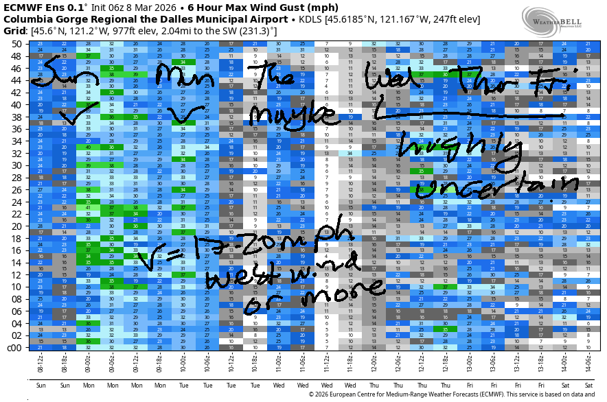
SHORT-TERM gorge wind forecast
Hi friends! Looks like some of you had an amazing day at the Hatch yesterday. Hopefully lots of you got it! West wind of some sort (but probably not like yesterday!) continues for the better part of the next week. Looking at this morning, we have pressures of 30.19/30.07/29.96 for early gradients of 0.12/0.11, which is a darn good start to the day. NWS has a wind advisory posted for the eastern Gorge today – that’s always a good sign.
Models suggest areas west of The Dalles will drop to 16-19mph early (Viento was reading 37mph when I got up) and hold at 16-19mph ish. Those models suggest you’ll need to head east of Avery today for best results: 30-33mph. After 2pm, we could see drizzle as far east as Arlington which will knock the wind speed down; that makes Threemile the all-day sweet spot today. River flow over the last 24 hours was 149-194kcfs (150-194kcfs at Rufus), river temps is 43.5F, and high temp forecast is 55F in Hood River and 65F way out in the desert.
RIVER FLOW FOR SITES BETWEEN AVERY (EAST OF THE DALLES) AND RUFUS: CLICK HERE FOR JOHN DAY DAM FLOW.
RIVER FLOW FOR SITES BETWEEN STEVENSON AND DOUG’S BEACH (WEST OF THE DALLES): CLICK HERE FOR THE DALLES DAM FLOW

LONGER-TERM gorge wind forecast
Monday starts with light westerlies, under 10mph, west of The Dalles. Out east, the day starts with 14-17mph all the way east to Hermiston. Afternoon westerlies rise to 10-13mph from Stevenson to Mosier with 25-28mph from Lyle to Hermiston. High temp: 46F to the west and 51F to the east.
Tuesday will probably be the lightest day of the week – models currently call for mid teens. Model agreement starts to fall apart on Wednesday. If we see wind, it’ll probably be late in the day and associated with a frontal system / low moving inland to BC – gusty and unreliable, but potentially quite strong. Beyond that, uncertainty precludes any sort of precise or reliable forecasting, so I’ll leave it here for now. Have fun out there, stay safe, and keep an eye on your buddies!

BARE BONES HOOD RIVER WEATHER FORECAST
Overcast early. Drizzle eventually. Temps start in the low 50s (RECORD HIGH-LOW) and end in the mid 50s. Moderate westerlies. 87% chance of rainbows. Monday will be partly cloudy with occasional sprinkles. Temps start in the mid 30s and rise to the mid 40s. Light westerlies. 99% chance of rainbows. Tuesday will be partly cloudy then mostly cloudy. Temps start in the low 30s and rise to the mid 40s. Light westerlies. No rainbows.
TEMIRA’S AWESOME TRAVEL ADVISORY SERVICE
HYPERLOCAL WEATHER FORECAST FOR THE COLUMBIA GORGE
THE DALLES, HOOD RIVER, WHITE SALMON, TROUT LAKE, STEVENSON, CASCADE LOCKS, PARKDALE, ODELL, HUSUM, BZ, MILL A, WILLARD, GOLDENDALE, RUFUS, ARLINGTON, boardman

Good morning, neighbors! ‘Twas a dark and stormy morning in the Gorge… well, it’s only kinda dark, and only feels dark because WE HAVE AN EXTRA HOUR OF LIGHT AT THE END OF THE DAY THANK THE STARS! I led a meditation group online for some British Columbia folks this morning, and they were SO EXCITED because they’re never changing the clocks again and staying on DST forever.
Here in the Gorge, we’re excited about the possibility of ANOTHER record high-low today (we set one in Hood River yesterday). It’s currently 50F at HOXO (WARM), and the record is 45F. Up in Glenwood, it’s 48F this morning, which is really, really, really warm for Glenwood in the middle of winter. It’s so warm this morning that nobody’s seen !CE, thankfully!
Today’s Gorge weather forecast
High temps for Sunday will rise to the mid 50s (west), low 60s (The Dalles), and mid 60s (The Desert). Drizzle is already falling on Underwood Mountain (I can see it, therefore I can rule it!) and will continue on-and-off as far east as Hood River into the evening. Starting late morning, drizzle extends to Celilo Village, and starting mid-afternoon, that drizzle makes it all the way to the Arlington Triangle. Wind today will be 25mph west of Lyle and 30mph to the east. The strongest wind will shift east ahead of the incoming rain.
Monday’s Gorge weather forecast
Overnight into Monday, a cold front zips through (like a zipping zipper) and takes the snow level down to 1000′ or so as -7C air filters in at 850mb (~5000′). Light snowfall is possible during the day Monday in Parkdale, Underwood, Stabler, Trout Lake, York Hill, and associated areas above 1000′. No more than 1” should fall, and it’s likely to be less than that, perhaps just a trace. Down in the lowlands, we have showers that occasionally reach as far east as Hood River. Wind will be light westerly early west of The Dalles with 15mph to the east. In the afternoon, the wind rises to 10-15mph west of Lyle and 25-30mph from Lyle to Hermiston. High temps on Monday range from 46F (west) to 48F (The Dalles) and 51F (The Desert).
Tuesday’s Gorge weather forecast
On Monday night into Tuesday morning, another round of light snow is possible. This time we could see snowflakes down to the Nch’i Wana. Helping this out: -8C air at 850mb and light wind. Parkdale, Underwood, Trout Lake, Mill A, York Hill, and Stabler could pick up 0.5” to 2” overnight. Lower down and west of Mosier: a trace to 1.5”. By the wee hours of Tuesday, precip will be done. We’ll have a dry, partly cloudy start to Tuesday. Those of you up high are likely to encounter icy roads. Temps on Tuesday max out in the mid 40s (west) and near 50F (The Dalles and areas to the east). Wind will be under 15mph and out of the west.
Extended Gorge weather forecast
Sometime in the Wednesday-Thursday window, a stronger, wetter weather system is expected. This one is almost certain to bring heavy precip for the Cascades and areas west of Mosier. Details are not yet clear, and part of what’s not clear is the associated temps. Most likely we’re just looking at rain in the lowlands. Please cross your fingers for mountain snow! Looking deeper into the future… another relatively warm spell is on tap starting around the 15th or 16th. That is all for now. Safe travels. -TATAS
HEY! DON’T STOP READING! Is this community-focused forecast helpful to you? It sure is! It takes me a couple hours a day to write. Please join your friends and neighbors in contributing to keep it going. Venmo: @thegorgeismygym PayPal: twomirrors@gmail.com USPS: Temira / PO Box 841 / Hood River, Oregon 97031 You can test out the forecast subscription for a few days for free by signing up below. Easy! Do it!
JONES BEACH, SAUVIE ISLAND, & COAST FORECAST
ON WINTER VACATION UNLESS DESPERATELY NEEDED.

Leave a Reply