

MT HOOD SNOW FORECAST

Hey skiers and snowboarders! Timberline managed to get Bruno’s open yesterday, which is better than nothing at all. Meadows is still working on opening some terrain, and may be hampered by the fact that Highway 35 remains closed between Parkdale (Baseline Drive) and (approximately) Little John (aka Weird Weather Flats). Teacup: also hampered by the closure and waiting to get in with heavy equipment to clean up 55 downed trees from the last storm. Skibowl: too low in elevation to have enough for us yet.
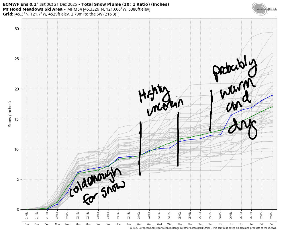
Coming up this week, we have approximately a foot of new snow total in our Mt Hood snow forecast. On Wednesday, models are all over the place about an incoming system. Temps at 850mb (~5000′) are forecast to be anywhere from -2.5C to +2.5C, so it’s impossible to say what precip type arrives with that system. Temps cool Thursday and rise again as the weekend approaches. That rise (and dry weather, thankfully) is in response to a multi-day ridge of high pressure. Beyond that, models have quite the spread of possibilities, but the general picture is cold with moderate snowfall. Let’s cross our fingers that the cold part of that forecast continues!
Short term Mt Hood snow forecast
Looking at Sunday, we have a cloudy day on Mt Hood with snow forecast tonight. The snow level will be 2500′ this morning, 3500-4000′ this afternoon, and 2500′ after midnight. Daytime: dry. Overnight: 0.6” water equivalent (WE) is forecast for about 6” increasingly light snow. Wind will be WSW 10 this morning, WSW 15-20 this afternoon, and WSW 25-30 overnight.
Monday daytime looks partly cloudy. Snow returns overnight. The snow level will be 2500′ in the morning, 4000′ in the afternoon, and 2500′ after midnight. Snow starts sometime between 4pm and 7pm. 0.3” to 0.4” WE is forecast for about 4” of relatively dry new snow. Wind: WSW 20-30 in the morning, SW 20-35 in the afternoon, and SW 10-20 after midnight.
Extended Mt Hood Snow Forecast
A trace of snow is forecast on Tuesday morning. As we move into Tuesday night, uncertainty increases. At this point, it’s impossible to say what form any incoming precipitation will take, so I’m not even going to guess. Ditto into Wednesday and Thursday. How about we just cross our fingers?
In the late Friday to Monday time frame, we”re (almost certainly) looking at warmer, dry weather for Mt Hood. Beyond Monday the 29th, models hint at a return to snowfall. Fingers crossed! Hope to see you on the snow soon!
Was that helpful? I knew it was! Guess what? All of this crucial work – from your personal wind and snow reports to the invaluable TATAS updates – is made possible by my relentless efforts. Maintaining this labor of love isn’t easy. Each daily forecast takes hours. Website hosting, weather model access, and back-end admin work takes time and money. That’s where you come in.
YOUR CONTRIBUTION MAKES A DIFFERENCE
- SUPPORT ACCURATE, HYPER-LOCAL WEATHER FORECASTING
- ENABLE ACCESS FOR ALL, EVEN THOSE WITH LESS MEANS
- SUPPORT A COOL HUMAN WHO WORKS HARD SO YOU CAN PLAY
Take a moment to click one of the buttons below. Donate $19.99 or more (how much does this forecast enhance your life?) and get the email in your inbox. Whether it’s a renewing subscription (auto-renew) or a one-time donation, every contribution makes a real difference. Help me keep this labor of love alive, so we can all continue playing, commuting, and living in the Gorge with peace of mind and the best weather forecasts possible. Thank you!


Hood River, Oregon 97031


GORGE WIND FORECAST
If you’re still seeing yesterday’s and it’s after 9am, try opening this in an incognito window
SHORT-TERM gorge wind forecast
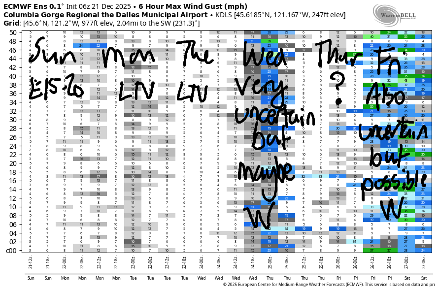
Hi friends! Not much happening in the next few days. On Wednesday, we run smack into high levels of model uncertainty. There’s some chance of a decent west wind day in there, but the chance isn’t all that high. Same thing on Friday – west wind is possible, but far from guaranteed.
Looking at Sunday, we started the day with 20-25mph at Iwash (Rooster) Rock and 15mph at both Stevenson and Viento. That’s what we’ll have for the morning. Afternoon wind falls to 10mph and turns calm after 4pm. Light westerlies are forecast overnight, but it’ll be dark. River flow over the last 24 hours was 190-221 kcfs, river temp is 48.7F, and high temp forecast is 43F. Watch out for debris in the river from recent high waters.
RIVER FLOW FOR SITES BETWEEN AVERY (EAST OF THE DALLES) AND RUFUS: CLICK HERE FOR JOHN DAY DAM FLOW.
RIVER FLOW FOR SITES BETWEEN STEVENSON AND DOUG’S BEACH (WEST OF THE DALLES): CLICK HERE FOR THE DALLES DAM FLOW

LONGER-TERM gorge wind forecast
Monday starts calm, picks up to E 10-15mph at the usual spots, and goes calm again in the afternoon. Once again, light westerlies are forecast overnight. High temp: 45F. Tuesday looks calm. High temp: 44F. Depending on how an incoming system evolves, it’s possible (25%) we could see a west wind day on Wednesday. Light wind is forecast Thursday. On Friday, west wind is again possible, but it’s far from certain. Let’s just cross our fingers for now (for both wind and snow!) and get on with our day!
BARE BONES HOOD RIVER WEATHER FORECAST
High clouds this morning. Cloudy later with rain after 4pm. Temps start in the mid 30s and rise to the low 40s. Light easterlies. 4% chance of rainbows. Monday will be cloudy with rain at night. Temps start in the mid 30s and rise to the mid 40s. Light/variable wind. No rainbows. Tuesday will be drizzly early and dry from midday on. Temps start in the mid 30s and rise to the mid 50s. Calm wind. 4% chance of rainbows.
TEMIRA’S AWESOME TRAVEL ADVISORY SERVICE
HYPERLOCAL WEATHER FORECAST FOR THE COLUMBIA GORGE
THE DALLES, HOOD RIVER, WHITE SALMON, TROUT LAKE, STEVENSON, CASCADE LOCKS, PARKDALE, ODELL, HUSUM, BZ, MILL A, WILLARD, GOLDENDALE, RUFUS, ARLINGTON, boardman
Good morning, neighbors, and happy Winter Solstice! Starting tomorrow, we’ll have slightly more light and slightly less dark. My wish: that this pattern spread from the world of weather to the minds of people. May there be more kindness, may there be more care, and may there be more of a sense of us together as a community of humanity. Here’s one way to start: lots of people have big messes to clean up from the recent windstorm. Lend a hand to your neighbors and notice the impact on your heart. This is your only opportunity: I’m not seeing any upcoming weather disasters in the next week or two unless something changes.
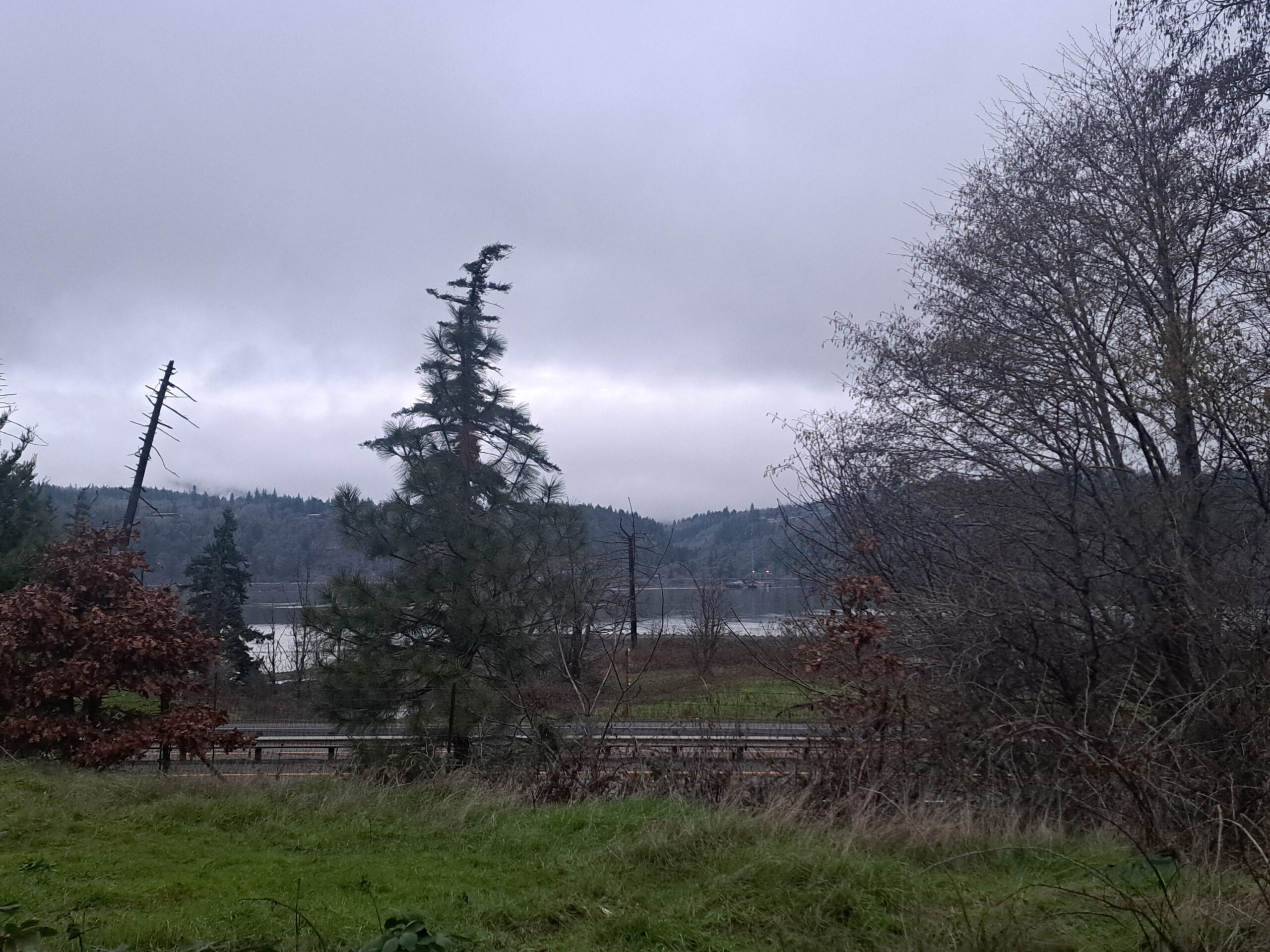
Glenwood this morning
Taking a look around this morning, we’ve got Glenwood at 30 degrees. Everyone in Glenwood is insisting that their age matches the temperature this morning – the youth want the wisdom that comes with time, and the elders want the health and ease of a youthful body. Other regional news: Highway 35 remains closed south of Parkdale to Weird Weather Flats (Little John area). Other other regional news: as of 7am, Gorge roads appeared to be clear of ¡CE.
Sunday Gorge weather forecast
Elsewhere in the Gorge this Sunday morning, temps are hovering in the 30-35F range with upper 30s in the east wind zones of the western Gorge. Radar shows some light snowfall in the southernmost parts of Wasco, Sherman, and Gilliam Counties. Snowflakes continue in those areas for a few hours this morning thanks to a sideswipe from a system to the south. The rest of us remain dry until this evening. A system comes from the west and reaches Underwood by 4pm. Make sure your Underwood Underoos are off the laundry line by then. Rain makes it to Celilo around 7pm, and Hermiston by 10pm. Commute alert: heavy rain west of Viento from 7pm through midnight. High temps today: low 40s. Snow level 2500′ early and 4000′ later. Wind: E 15-20mph at Iwash (dong) Rock and Stevenson this morning. Calm this afternoon.
Monday Gorge weather forecast
On Monday, we’ll have light drizzle before daybreak as far east as Mosier. Next up: a dry day. Next up: another round of rain overnight as far east as The Dalles. Between 7pm and 10pm, that rain will be heavy enough in the western Gorge to make puddles on I-84. Temps start in the mid 30s and rise to the mid 40s. Wind: Calm, then light easterlies, then calm, then light westerly overnight.
Extended Gorge weather forecast
We’ll probably see a cloudy, drizzly start to Tuesday followed by dry weather much of the day. Uncertainty in the models Tuesday night leaves me unable to make a precision forecast. We’ll probably see rain Tuesday night into Wednesday. Tuesday temps: 35F in the morning, 44F in the afternoon with calm wind and cloudy sky. Some precip is likely on Thursday.
From Friday on into the start of next week, dry weather is almost certain. Depending on the strength of the ass-ociated (“ociate” – past tense, short form “Oh, I see it, then I eat it”) inversion, we may/may not see some Nothing clouds. Models currently have a mere morning Nothing with the possibility of sun in the afternoon. Sun would be amazing. In the winter around here, the sun (usually) only shines on TV. My fingers are crossed. Cross yours too, please. Safe travels. -TATAS
HEY! DON’T STOP READING! Is this community-focused forecast helpful to you? It sure is! It takes me a couple hours a day to write. Please join your friends and neighbors in contributing to keep it going. Venmo: @thegorgeismygym PayPal: twomirrors@gmail.com USPS: Temira / PO Box 841 / Hood River, Oregon 97031 You can test out the forecast subscription for a few days for free by signing up below. Easy! Do it!
JONES BEACH, SAUVIE ISLAND, & COAST FORECAST
ON WINTER VACATION UNLESS DESPERATELY NEEDED.
