

MT HOOD SNOW FORECAST

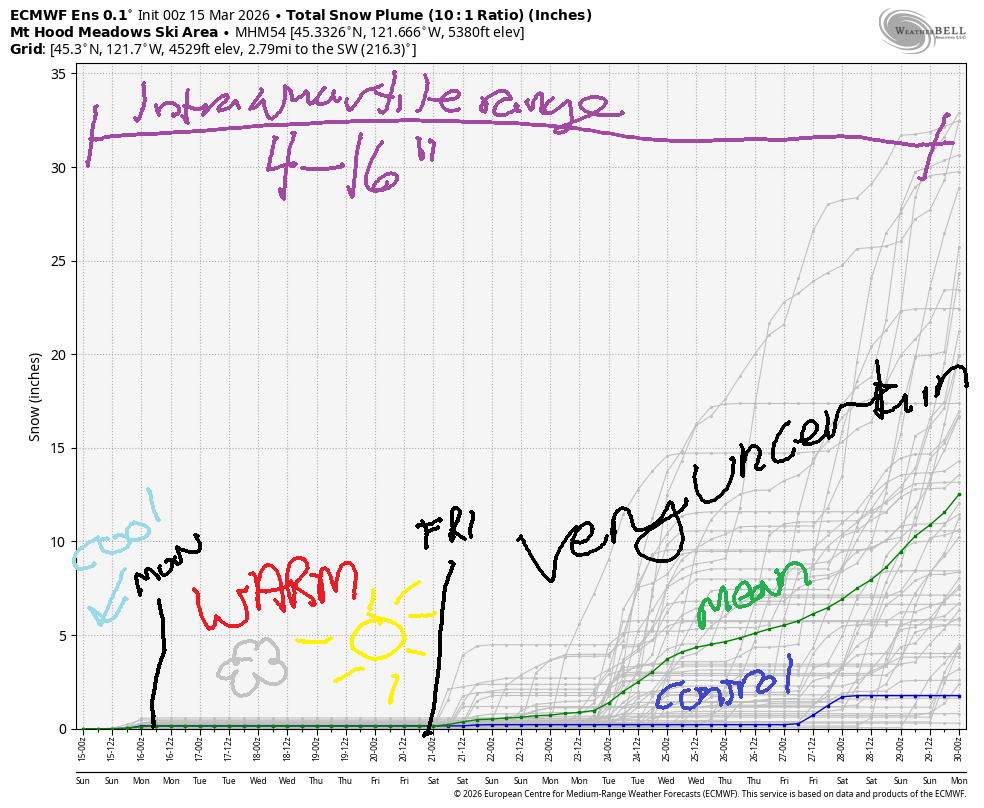
Hey skiers and snowboarders! Looks like we’re heading into a period of spring skiing this week after a cool day on Sunday. For the most part, we should stay dry, and temps will remain too warm for snow through at least the end of the week. Through the end of the month, the intraquartile range for snowfall is just 4-16”. Ouch.
Sunday will be a cloudy day on Mt. Hood. A little drizzle is possible late afternoon or early evening, but if it happens, it’ll be just a trace. The snow level will be 1000′ early, 8000′ in the afternoon, and 12,000′ overnight with temps rising to 40F at 5000′ in the afternoon. Wind today will be variable to 15 early, SW 10-20 in the afternoon, and W 35-40 overnight.
Short term Mt Hood snow forecast
Monday looks cloudy in the morning and mostly clear in the afternoon. The free air freezing level starts higher than 10,000′ and stays there. With cloudy sky overnight and breezy conditions, it’s possible the snow will refuse to set up. If so, any softening from Sunday will be around for the start of Monday. Temps max out at nearly 50F at 5000′. Wax warm. Wind: W 35-40 in the morning, WSW 25-35 in the afternoon, and W 40 overnight.
Tuesday will be cloudy with a chance of drizzle in the morning. Looks like we’ll be partly cloudy in the afternoon. The snow level will be 12,000′ all day, and temps will max out near 50F. Wind: W 40 in the morning, W 20-30 midday, SW 25-35 in the afternoon, and W 35 overnight.
Extended Mt Hood Snow Forecast
Looking at the extended forecast…. we have partly cloudy, warm weather on Wednesday with moderate wind. Sunshine is forecast on Thursday. Beyond that, uncertainty really increases, especially around the temp forecast. About 50% of the ensemble members have some precip in the Friday-Saturday period, but that’s far from a promise.
High levels of uncertainty continue until the end of the month. Sometimes we see the uncertainty contained below 32F. As of now, the uncertainty contains 32F, but many of the possibilities are above freezing, meaning snow is far from guaranteed. As a matter of fact, as I said earlier, snowfall through the end of the month is just 4-16” in the latest intraquartile range. Good thing we just picked up a few feet. Make the most of it!
Was that helpful? I knew it was! Guess what? All of this crucial work – from your personal wind and snow reports to the invaluable TATAS updates – is made possible by my relentless efforts. Maintaining this labor of love isn’t easy. Each daily forecast takes hours. Website hosting, weather model access, and back-end admin work takes time and money. That’s where you come in.
YOUR CONTRIBUTION MAKES A DIFFERENCE
- SUPPORT ACCURATE, HYPER-LOCAL WEATHER FORECASTING
- ENABLE ACCESS FOR ALL, EVEN THOSE WITH LESS MEANS
- SUPPORT A COOL HUMAN WHO WORKS HARD SO YOU CAN PLAY
Take a moment to click one of the buttons below. Donate $19.99 or more (how much does this forecast enhance your life?) and get the email in your inbox. Whether it’s a renewing subscription (auto-renew) or a one-time donation, every contribution makes a real difference. Help me keep this labor of love alive, so we can all continue playing, commuting, and living in the Gorge with peace of mind and the best weather forecasts possible. Thank you!


Hood River, Oregon 97031


GORGE WIND FORECAST
If you’re still seeing yesterday’s and it’s after 9am, try opening this in an incognito window
SHORT-TERM gorge wind forecast
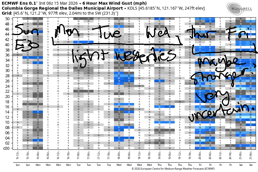
Hi friends! High pressure settles in over the US west and desert Southwest this week and leaves us with light west wind most days. The exception is Sunday, when cool air in the desert combines with incoming warm air on the west side for easterlies.
Sunday morning started with pressures of 30.42/30.45/30.47 for light east gradients and light offshore wind. Models bring the wind up mid-morning: 30-35mph at Iwash (Rooster) Rock and 25-30mph at Stevenson. Iwash may briefly rise to 40mph before dropping quickly in the afternoon. After 5pm, both Iwash and Stevenson will be down to 10mph or so. River flow over the last 24 hours was 210-242kcfs, river temp is 45.1F, and high temp forecast is 51F and cloudy with a little afternoon drizzle.
RIVER FLOW FOR SITES BETWEEN AVERY (EAST OF THE DALLES) AND RUFUS: CLICK HERE FOR JOHN DAY DAM FLOW.
RIVER FLOW FOR SITES BETWEEN STEVENSON AND DOUG’S BEACH (WEST OF THE DALLES): CLICK HERE FOR THE DALLES DAM FLOW

LONGER-TERM gorge wind forecast
Monday brings westerlies at 17-20mph from Viento to the Hatch to start the day. In the afternoon, wind speed drops off, but areal coverage increases. We should see 14-17mph form Stevenson to The Dalles with Rufus potentially joining at 20-23mph. High temp: 66F for Hood River with cloudy sky.
Tuesday starts with 13-16mph from Viento to the Hatch and also at Rufus with lighter wind in between those zones. Afternoon wind falls to 7-10mph. High temp: 63F under cloudy sky. Similarly light to moderate conditions are forecast for the rest of the week. Beyond Friday, models struggle to create any sort of agreement, so I’ll leave it here for now. Fingers crossed for a big west wind day after the warm weather this week!

BARE BONES HOOD RIVER WEATHER FORECAST
Clouds all day. Temps start in the mid 30s and rise to the low 50s. A little drizzle is possible this evening. Light easterlies. No rainbows. Monday will be cloudy in the morning and mostly clear in the afternoon. Temps start near 40 and rise to the mid 60s. Moderate westerlies. No rainbows. Tuesday will be cloudy. Temps start in the upper 40s and rise to the low 60s. Light drizzle is possible in the afternoon. Moderate westerlies 32% chance of rainbows.
TEMIRA’S AWESOME TRAVEL ADVISORY SERVICE
HYPERLOCAL WEATHER FORECAST FOR THE COLUMBIA GORGE
THE DALLES, HOOD RIVER, WHITE SALMON, TROUT LAKE, STEVENSON, CASCADE LOCKS, PARKDALE, ODELL, HUSUM, BZ, MILL A, WILLARD, GOLDENDALE, RUFUS, ARLINGTON, boardman
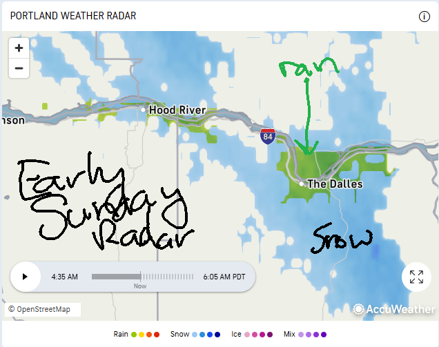
Good morning, neighbors! I dunno what to tell you about this weather – now that we’re done with the Pineapple Express, we’ll head into few days of warm, but not quite sub-tropical high temps. This bout of warm weather is related to a very strong ridge building over the western US – this takes temps well above normal pretty much everywhere covered by the “US West” temperature anomaly map. Unless something changes, precipitation looks pretty limited through the end of the month. Speaking of precip, the radar is showing some light precip this morning – rain down low and snow up high.
Glenwood this morning
Glenwood was reading 30F as I was typing this. Nothing to write home about there. For the few of you seeing flurries, you can expect those to end soon. Icy roads are possible out and about today especially on the passes. For those of you needing to head north, know that I-5 has reopened after a landslide closure near Dike Access Road yesterday.
Today’s Gorge weather forecast
Today’s weather here in the Gorge will be cloudy. We may add another round of light drizzle from 2pm-8pm between Cascade Locks and Hood River. Other than that, dry following a few sprinkles / flurries this morning. Temps rise to 51F all across the lowlands, and the freezing level rises above all our inhabited zones tonight. After a light wind start, easterlies rise to 25-35mph at Iwash (schl*ng) Rock and Stevenson before dropping to 10mph this afternoon.
Monday’s Gorge weather forecast
Clouds Monday morning give way to partly cloudy sky in the afternoon. We’ll be on the south side of an atmospheric river terrorizing northern WA and BC and on the north side of a strong ridge terrorizing the desert SW, where an extreme heat watch is posted. We’re left mild – mid 60s – and cloudy early with clearing sky in the afternoon. Add in west wind at 15mph west of Mosier in the morning and as far east as Rufus in the afternoon for a rather pleasant spring day.
Extended Gorge weather forecast
Tuesday looks nearly identical. Wednesday and Thursday looks rather similar with varying degrees of cloud cover, varying degrees of light-to-moderate west wind, and temps pushing into the 60-70F range (warmer to the east, cooler to the west) each day. Starting Friday, uncertainty rises. While I can’t make any precision forecasts beyond Thursday, I can tell you that wintry weather is highly unlikely between now and the end of the month. Also unlikely: a repeat of last week’s heavy rain. Safe travels. -TATAS
HEY! DON’T STOP READING! Is this community-focused forecast helpful to you? It sure is! It takes me a couple hours a day to write. Please join your friends and neighbors in contributing to keep it going. Venmo: @thegorgeismygym PayPal: twomirrors@gmail.com USPS: Temira / PO Box 841 / Hood River, Oregon 97031 You can test out the forecast subscription for a few days for free by signing up below. Easy! Do it!
JONES BEACH, SAUVIE ISLAND, & COAST FORECAST
ON WINTER VACATION UNLESS DESPERATELY NEEDED.

Leave a Reply