

MT HOOD SNOW FORECAST

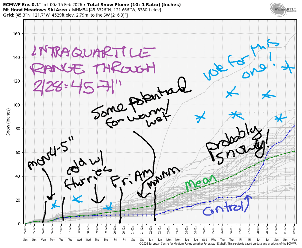
Hey skiers and snowboarders! Another 5” of new snow fell on Mt. Hood last night. That’s a super-welcome addition to a snowpack that still measures “lowest-ever”. For this week, we’re looking at light and intermittent snowfall. Through Friday evening, we’re expecting 10-15” of new snow. Through the end of the month, 45-71” is forecast in the intraquartile range. In a concerning twist, but definitely not a universal one in the ensembles, the GFS deterministic wants to give us a warm atmospheric river next weekend. Let’s hold off on freaking out – there’s plenty of indication we’ll remain snowy next weekend.
Short term Mt Hood snow forecast
For today, Sunday, we’ll have light snow in the morning and light snow in the evening with intermittent light flurries during the day under cloudy sky. The snow level will be around 2500′ early, 4000′ in the afternoon, and 3500′ after midnight. About 0.1” water equivalent (WE) is forecast in the morning for an inch of new. Same overnight. Wind will be SW 10-20 all day becoming WSW 10-15 after midnight.
Monday brings another round of snow and dropping temps. The snow level will be 3500′ in the morning, 2000′ in the afternoon, and 0′ near Mt. Hood overnight. About 0.4” WE is forecast during the day. Another 0.1” to 0.2” WE is expected overnight. That gives us 4-5” increasingly dry snow during the day and 1-3” dry powder overnight. Wind will be WSW 10-15 in the morning, WSW 25-30 in the afternoon, and SW 10-15 after midnight.
Extended Mt Hood Snow Forecast
Colder weather is forecast on Tuesday. A few snow flurries in the morning give way to mostly clear sky in the afternoon and clouds with a few flurries overnight. The snow level will be 0′ in the morning, 1500′ in the afternoon, and 0′ overnight. Temps range from the upper teens to low 20’s at 5000′. Total snowfall will be under an inch for the 2 4hours period. Wind: SW 10-15 in the morning, light/variable in the afternoon, and NW 5-10 after midnight.
Wednesday brings cool (low 20s), cloudy weather with a few flurries during the day and night. The snow level will be 0-1000′ all day with wind under 15mph out of the west. Cold weather sticks around on Thursday with the potential for a couple inches of snow. Model uncertainty increases starting Friday, as I alluded to earlier. That GFS deterministic prediction of a warm/wet period is unsettling, but the ensembles haven’t jumped on board with that yet. They still keep temps under 32F at 5000′ and bring in significant moisture day after day. Fingers crossed – I’m sure we’d all love to see an exponential increase in the snowpack! Have a great day on Mt Hood today!
Was that helpful? I knew it was! Guess what? All of this crucial work – from your personal wind and snow reports to the invaluable TATAS updates – is made possible by my relentless efforts. Maintaining this labor of love isn’t easy. Each daily forecast takes hours. Website hosting, weather model access, and back-end admin work takes time and money. That’s where you come in.
YOUR CONTRIBUTION MAKES A DIFFERENCE
- SUPPORT ACCURATE, HYPER-LOCAL WEATHER FORECASTING
- ENABLE ACCESS FOR ALL, EVEN THOSE WITH LESS MEANS
- SUPPORT A COOL HUMAN WHO WORKS HARD SO YOU CAN PLAY
Take a moment to click one of the buttons below. Donate $19.99 or more (how much does this forecast enhance your life?) and get the email in your inbox. Whether it’s a renewing subscription (auto-renew) or a one-time donation, every contribution makes a real difference. Help me keep this labor of love alive, so we can all continue playing, commuting, and living in the Gorge with peace of mind and the best weather forecasts possible. Thank you!


Hood River, Oregon 97031


GORGE WIND FORECAST
If you’re still seeing yesterday’s and it’s after 9am, try opening this in an incognito window
SHORT-TERM gorge wind forecast
Hi friends! Not much happens in the next five days other than some moderate easterlies today (Sunday) followed by moderate westerlies on Monday. Sunday started with light offshore gradients and 30mph at Iwash (Rooster) Rock. Elsewhere, wind was under 10mph. Models level out Iwash and Stevenson at 15-20mph midday before an afternoon die-off. Stevenson ends at 15mph, and Iwash ends light/variable. River flow over the last 24 hours was 133-183kcfs, river temp is 41.7F, and high temp forecast is 47F with mostly clear sky after a rainy morning.
RIVER FLOW FOR SITES BETWEEN AVERY (EAST OF THE DALLES) AND RUFUS: CLICK HERE FOR JOHN DAY DAM FLOW.
RIVER FLOW FOR SITES BETWEEN STEVENSON AND DOUG’S BEACH (WEST OF THE DALLES): CLICK HERE FOR THE DALLES DAM FLOW

LONGER-TERM gorge wind forecast
Monday starts with light west flow. By mid-morning, the wind briefly rises to gusty 17-20mph out of the west from Stevenson to The Dalles. Westerlies fill in at 13-16mph from Stevenson to Arlington midday and then fade to 10-13mph in the afternoon. High temp: 44F with rain in the morning and rain in the afternoon.
Tuesday and Wednesday both look light and variable with high temps in the low 40s. Thursday brings light east wind. Beyond that, there’s quite a bit of uncertainty in the models, but there are no solid signs of big west or east wind days, at least not until late next weekend when easterlies may return. Stay warm and safe out there!
BARE BONES HOOD RIVER WEATHER FORECAST
Cloudy and showery this morning. Mostly clear this afternoon. Temps start in the upper 30s and rise to the upper 40s. Light easterlies. 67% chance of rainbows. Monday will be rainy then dry then rainy. Temps start in the upper 30s and rise to the mid 40s. Light to moderate westerlies. 99.9% chance of rainbows. Tuesday will be drizzly early then mostly cloudy with a few sprinkles. Temps start in the low 30s and rise to the low 40s. Light and variable wind. 39% chance of rainbows.
TEMIRA’S AWESOME TRAVEL ADVISORY SERVICE
HYPERLOCAL WEATHER FORECAST FOR THE COLUMBIA GORGE
THE DALLES, HOOD RIVER, WHITE SALMON, TROUT LAKE, STEVENSON, CASCADE LOCKS, PARKDALE, ODELL, HUSUM, BZ, MILL A, WILLARD, GOLDENDALE, RUFUS, ARLINGTON, boardman
Good morning, neighbors! Winter finally booked a ticket to the Gorge. Starting Monday night, cooler, damp weather is forecast with intermittent flurries. A little bit of snow is in the forecast this week for you, yes you! More concerning: icy roads are definitely going to make an appearance. It’s possible we could see more interesting weather at the end of next week or next weekend…
Glenwood this morning and today’s Gorge weather forecast
This morning (it’s Sunday), we just have wet roads and rain with the snow level around 2500′. Glenwood’s reading 35F this morning, but Parkdale (31-33F) and Trout Lake (30-33F) are a bit colder and could be seeing some snow this morning. By mid-morning, the moisture shuts off and we’re left with clearing skies. A few sprinkles are possible near Parkdale today, but other than that… sun is coming! Temps ends up in the upper 40s all across the lowlands, and east wind fades from 30mph to less than 15mph near Iwash (dong) Rock and Stevenson.
Monday’s Gorge weather forecast
Overnight, clouds return. Rain starts up in the wee hours of Monday and stretches all the way east to the Tri-Cities. Models indicate a band of moderate to heavy moisture stretching from Hood River into south Wasco, Sherman, Gilliam, and Klickitat Counties with the heaviest rain between The Dalles and Arlington. That will make for an unpleasant morning drive. Rain ends east of The Dalles early afternoon, but another system coming from the west returns rain to areas west of The Dalles. This second system is colder and will take the snow level from 3500′ down to 0-1000′ overnight. While there won’t be much moisture left as the temps are dropping, 1-2” of snow is possible above 2000′ and and inch of snow above 1000′ west of The Dalles. Monday wind: light westerly to start with 15mph west wind midday from Stevenson all the way to Arlington. Daytime high temps finish in the mid to upper 40s after an upper-30F start.
Tuesday’s Gorge weather forecast
Colder weather is forecast on Tuesday (and beyond) as a chilly Alaskan trough settles in over the PNW. Expect icy roads on Tuesday morning potentially down to river level. Clouds may inhibit ice formation down low on the west side. To the east: mostly clear sky starts the day and leaves you certain to have icy roads. Add in very light snowfall above 500′ (potentially lower) as far east as Appleton (up high) and Hood River (down low). Dry weather (mostly) returns mid-afternoon, but models then suggest the possibility for some anomalous precipitation between Rowena and Celilo Village and in south Wasco County overnight. Let’s hold off on any warnings about that for now and see what models say tomorrow. Other Tuesday info: 25-30F to start (colder where it’s clear) and low 40s to finish with light/variable wind.
Extended Gorge weather forecast
Wednesday looks much like Tuesday: icy roads, a few flurries or sprinkles late in the day west of The Dalles. Temps below freezing to start and in the low 40s later. Models suggest light snowfall (flurries, mostly) on Thursday and potentially Friday; as we approach the end of the week, uncertainty rises. A significant portion of the ensembles crank up the precipitation starting next Saturday or Sunday and keep things quite wet through the end of the month. As long as temps stay cold enough for mountain snow, that’s going to be a very welcome pattern change despite the gray, wet weather in the lowlands! Safe travels. -TATAS
HEY! DON’T STOP READING! Is this community-focused forecast helpful to you? It sure is! It takes me a couple hours a day to write. Please join your friends and neighbors in contributing to keep it going. Venmo: @thegorgeismygym PayPal: twomirrors@gmail.com USPS: Temira / PO Box 841 / Hood River, Oregon 97031 You can test out the forecast subscription for a few days for free by signing up below. Easy! Do it!
JONES BEACH, SAUVIE ISLAND, & COAST FORECAST
ON WINTER VACATION UNLESS DESPERATELY NEEDED.
