

MT HOOD SNOW FORECAST

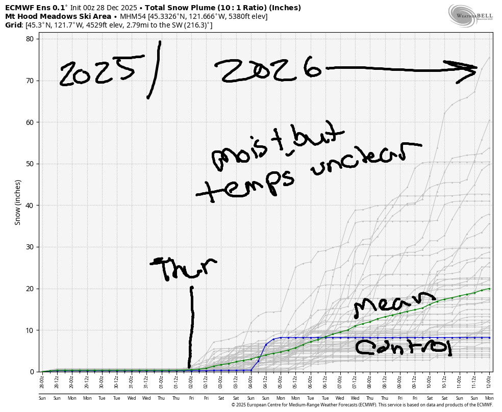
Hey skiers and snowboarders! Hopefully you’re ready for sunshine, because we have four or five days of the golden sky globe in the forecast. Beyond that, models hint at some r**n as we come out of this high-pressure, dry-weather pattern. That said, there’s quite a bit of uncertainty in the forecast starting Thursday. We’ll talk more about that in a bit.
Short term Mt Hood snow forecast
Sunday started out with clear sky above the slopes, and we’re expecting a mostly sunny day, or at worst, sunshine filtered through some high clouds. The free air freezing level (FAF) will be 500′ this morning and will slowly rise to 5500′ by tonight. Temps start near 23F and rise to 32F at 5000′. Wind will be N 15-20mph early, N 10 midday, and E 10 from the afternoon on through the night. No new snow.
Monday looks partly high overcast with filtered sun. The FAF will be 5500′ in the morning, 9000′ in the afternoon, and 11,000′ overnight with temps potentially hovering below freezing in the lower elevations thanks to an inversion. Also thanks to the inversion: wind variable to 10mph depending on elevation. Temps at 5000′ max out in the mid 30s to mid-upper 40s with wild swings in the temps possible.
Extended Mt Hood Snow Forecast
Tuesday and Wednesday look similar – sun, filtered through high clouds at times. FAF: above 10,000′. Max temps: mid to upper 40s at 5000′ with colder temps possible at lower elevations thanks to a continuing inversion. Wind Tuesday and Wednesday will be under 10mph out of various southerly directions.
Our next system potentially arrives on Thursday. As of this morning, models don’t indicate all that much moisture, but they do indicate temps will be above freezing when that moisture arrives. Looking deeper into the future, we have the GFS calling for mean 850mb (~5000′) temps to hover right around 0C/32F for the extended period. The Euro has a wider range of possible temps (more uncertainty), with the mean below freezing next weekend and then rising above freezing after that starting around the 6th of January.
Honestly, there’s just too much uncertainty to make any sort of prediction beyond next Thursday, so I’ll hold off. That said, I’d definitely prefer to see the mean hovering well below 0C for a clear sign of snowfall in the extended forecast. Let’s just get up and play in the snow and make the most of what we have right now!
Was that helpful? I knew it was! Guess what? All of this crucial work – from your personal wind and snow reports to the invaluable TATAS updates – is made possible by my relentless efforts. Maintaining this labor of love isn’t easy. Each daily forecast takes hours. Website hosting, weather model access, and back-end admin work takes time and money. That’s where you come in.
YOUR CONTRIBUTION MAKES A DIFFERENCE
- SUPPORT ACCURATE, HYPER-LOCAL WEATHER FORECASTING
- ENABLE ACCESS FOR ALL, EVEN THOSE WITH LESS MEANS
- SUPPORT A COOL HUMAN WHO WORKS HARD SO YOU CAN PLAY
Take a moment to click one of the buttons below. Donate $19.99 or more (how much does this forecast enhance your life?) and get the email in your inbox. Whether it’s a renewing subscription (auto-renew) or a one-time donation, every contribution makes a real difference. Help me keep this labor of love alive, so we can all continue playing, commuting, and living in the Gorge with peace of mind and the best weather forecasts possible. Thank you!


Hood River, Oregon 97031


GORGE WIND FORECAST
If you’re still seeing yesterday’s and it’s after 9am, try opening this in an incognito window
SHORT-TERM gorge wind forecast
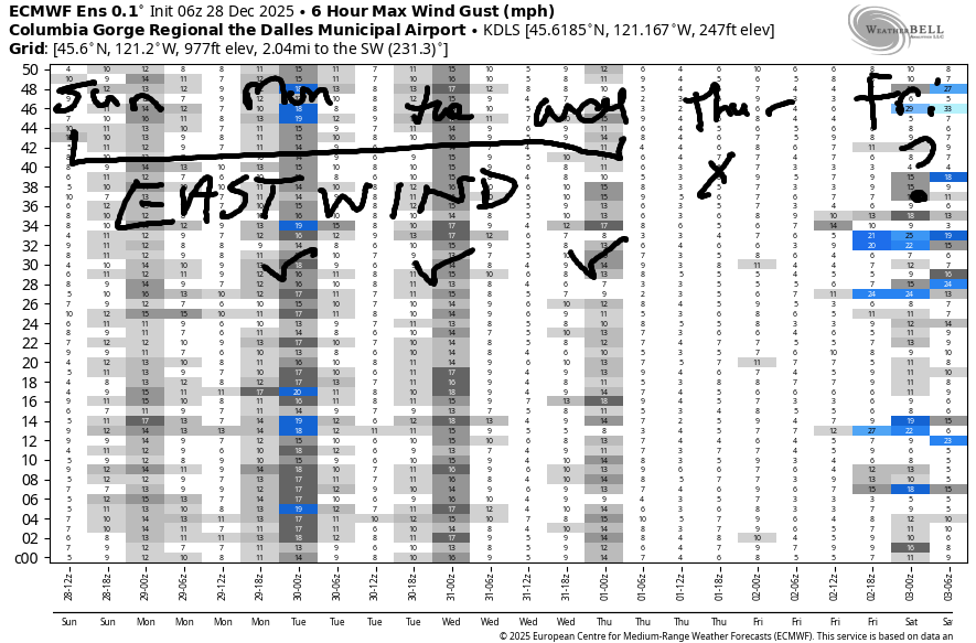
Hi friends! Many days of east wind are in the cards starting today, and many of these days should be plenty windy for any of the wind sports. With sunshine and temps around 40 in the cards, these won’t be the warmest, of easterlies, but they won’t be the coldest either!
Sunday kicks off with light easterlies as gradients are barely offshore to start the day. As high pressure builds inland, we’ll see the wind pick up today. Midday: 20-25mph at both Iwash (Rooster) and Stevenson. Afternoon: 30-35mph at Iwash and 25mph at Stevenson. River flow over the last 24 hours was 166-215kcfs, river temp is 46.0F, and high temp forecast is 41F under mostly sunny sky.
RIVER FLOW FOR SITES BETWEEN AVERY (EAST OF THE DALLES) AND RUFUS: CLICK HERE FOR JOHN DAY DAM FLOW.
RIVER FLOW FOR SITES BETWEEN STEVENSON AND DOUG’S BEACH (WEST OF THE DALLES): CLICK HERE FOR THE DALLES DAM FLOW

LONGER-TERM gorge wind forecast
Monday starts with easterlies at 40-45mph at Iwash and 30-35mph at Stevenson with 20mph at Viento. In the afternoon, the wind drops to 30mph at Stevenson and 40mph at Iwash. High temp: 40F with partly high overcast sky.
Similar conditions are forecast for Tuesday and Wednesday with slightly stronger wind possible on Tuesday. We’ll alternate between clear sky and high clouds, and temps will max out in the upper 30s to low 40s both days. Slightly lesser east wind is forecast on Thursday as the ridge of high pressure starts to break down. That’s all I’ve got for you today. Enjoy your time on the river. Dress warmly, have an emergency plan in place, and keep an eye on your buddies!
BARE BONES HOOD RIVER WEATHER FORECAST
Nothing this morning. Partly high cloudy later. Temps start in the mid 30s and rise to the low 40s. Light easterlies. No rainbows. Monday starts high overcast and ends mostly sunny. Temp start in the upper 20s and rise to 40. Light easterlies. No rainbows. Tuesday will be partly Nothing then clear. Temps start in the mid 20s and rise to the upper 30s. Light easterlies. No rainbows.
TEMIRA’S AWESOME TRAVEL ADVISORY SERVICE
HYPERLOCAL WEATHER FORECAST FOR THE COLUMBIA GORGE
THE DALLES, HOOD RIVER, WHITE SALMON, TROUT LAKE, STEVENSON, CASCADE LOCKS, PARKDALE, ODELL, HUSUM, BZ, MILL A, WILLARD, GOLDENDALE, RUFUS, ARLINGTON, boardman

Good morning, neighbors! That’s a good-looking Nothing we’ve got out there this morning. If you get above it, you’ll find filtered sun through thin high clouds. This, plus or minus the Nothing, is our forecast through at least Wednesday. There’s a wee chance of some light freezing rain here and there on Thursday, but things would have to line up just right for that to happen. Beyond that: really nothing catching my eye as concerning.
Glenwood this morning
Concerning this morning: just 25 degrees in Glenwood and low 30s most other places. Likely: black ice, and definitely on the way to Meadows – the road was soaking wet when I left there yesterday afternoon. Fortunately, there haven’t been any ¡CE sightings around this morning – that kind of ice is unquestionably more dangerous than the stuff that forms on the road.
Today’s Gorge weather forecast
Today’s weather models insist that the low clouds will burn off and leave us with a mix of high clouds and blue sky. Please! Temps max out around 40F today from The Dalles westward and mid 30s out in the desert, where cold air is gathering like cats to catnip. While the wind is light this morning, it’ll pick up to 35mph at Iwash (pizzle) Rock and 25mph at Stevenson this afternoon.
Extended Gorge weather forecast
Weather for Monday, Tuesday, and Wednesday can be lumped into one forecast. We’ll have low temps in the upper 20s with high temps near 40. Intermittent high clouds alternate with clear sky. Most likely day for a morning Nothing: Tuesday. Wind will be easterly at 40-50mph near Iwash and 30-35mph near Stevenson with variable wind to 10mph up in the hills.
Models hint at the ridge of high pressure breaking down on Thursday, but these ridges often last longer than initially forecast. Just a little precipitation (snow level 8000′) is forecast with this first system. If the timing is right and cold air is lingering at lower elevations, we could see a trace of freezing rain. As of right now, temps look marginal, and the timing is unclear, so I’m not posting any warnings. Merely speculating on possibilities (which is a little too close to “speculum” for my comfort). Beyond Thursday, we continue with a return to wetter weather. A major winter weather event looks unlikely in the next couple of weeks. Hmph. Not very impressive so far, La Niña. Safe travels. -TATAS
HEY! DON’T STOP READING! Is this community-focused forecast helpful to you? It sure is! It takes me a couple hours a day to write. Please join your friends and neighbors in contributing to keep it going. Venmo: @thegorgeismygym PayPal: twomirrors@gmail.com USPS: Temira / PO Box 841 / Hood River, Oregon 97031 You can test out the forecast subscription for a few days for free by signing up below. Easy! Do it!
JONES BEACH, SAUVIE ISLAND, & COAST FORECAST
ON WINTER VACATION UNLESS DESPERATELY NEEDED.
