

MT HOOD SNOW FORECAST

Hey skiers and snowboarders! Let’s celebrate the small things! Last night, thanks to clear sky and very low humidity, the snowpack froze hard and deep. This sets us up for an excellent spring skiing day. Instead of bottomless slush, we’ll have a solid base with (after a bit of warming) a thin layer of corn snow. It’s going to be fun! It’s possible we’ll have another decent corn day Monday, but rain returns to the mountain on Tuesday.
Short term Mt Hood snow forecast
Sunday will be sunny. High clouds join at some point. The free air freezing level will be 0-3000′ depending on location this morning with temps in the mid 20s. The freezing level rises to 8000′ this afternoon. Afternoon brings highs near 40F at 5000′. Wind will be light and variable all day. Expect frozen granular early with corn snow later. Gonna be awesome!
Monday will be mostly clear to start then cloudy. The free air freezing level holds around 8500′ all day and rises to 10,000′ overnight. Temps max out around 40F. Wind will be variable to 10 early, SW 5-15 in the afternoon, and SW 15-30 overnight.
Extended Mt Hood Snow Forecast
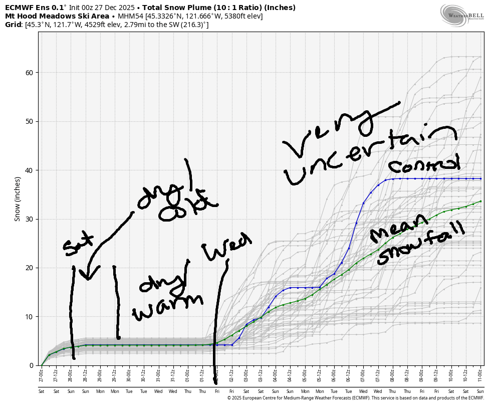
On Tuesday, clouds start the day. By mid-morning, rain arrives. Models are all over the place on how much precip we’re expecting for the 24 hour period: 0.6” to 1.1”. With the snow level starting around 10,000′ and eventually falling to 1500′ after the system passes, most of this precip will fall as rain. Models do give us a shot at 3” or so of new snow at 5000′ thanks to orographic effects at the back end of this system. Please cross your fingers. Wind will be SW 15-30 early, SW 30-50 in the afternoon (not problematic other than Cascade/Vista) and W 40-45 after midnight.
Flurries and/or light snowfall linger Wednesday morning with an inch or so of new snow possible down to 2500′. By midday, the sky clears. The freezing level ends the day at 2500′ and falls to 1000-1500′ overnight. Temps max out in the mid to upper 20s during the day. Wind will be W 40-5 early, WSW 25-30 mid-morning, W 25 in the afternoon, and NW 20-30 after midnight.
Warm weather is forecast Thursday and Friday and probably Saturday. Uncertainty is vast starting Saturday, but there’s a general downward trend in temps. It’s possible we could see some snow Sunday or Monday. Let’s cross our fingers and hope for the best. The intraquartile range through April 6th is 6-15” of snowfall. Better than nothing. Enjoy the epic spring snow today!
Was that helpful? I knew it was! Guess what? All of this crucial work – from your personal wind and snow reports to the invaluable TATAS updates – is made possible by my relentless efforts. Maintaining this labor of love isn’t easy. Each daily forecast takes hours. Website hosting, weather model access, and back-end admin work takes time and money. That’s where you come in.
YOUR CONTRIBUTION MAKES A DIFFERENCE
- SUPPORT ACCURATE, HYPER-LOCAL WEATHER FORECASTING
- ENABLE ACCESS FOR ALL, EVEN THOSE WITH LESS MEANS
- SUPPORT A COOL HUMAN WHO WORKS HARD SO YOU CAN PLAY
Take a moment to click one of the buttons below. Donate $19.99 or more (how much does this forecast enhance your life?) and get the email in your inbox. Whether it’s a renewing subscription (auto-renew) or a one-time donation, every contribution makes a real difference. Help me keep this labor of love alive, so we can all continue playing, commuting, and living in the Gorge with peace of mind and the best weather forecasts possible. Thank you!


Hood River, Oregon 97031


GORGE WIND FORECAST
If you’re still seeing yesterday’s and it’s after 9am, try opening this in an incognito window
SHORT-TERM gorge wind forecast
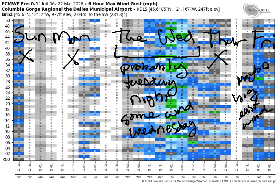
Hi friends! It was fun playing on the river with you yesterday. In an interesting twist, there were ZERO classic windsurfers at the Hatch on Saturday. There were wingers, paddlers, a kiter, a windsurf-foiler, and plenty of parawingers, but not a single windsurfer. Hopefully you were out yesterday, because there’s not much wind coming up other than overnight Tuesday.
Sunday starts with pressures of 30.40/30.36/30.36 and light west wind. Highest speed was 12mph out of the weest at Viento. Models turn the wind around midday. We’re expecting E 15-20mph at both Iwash/Rooster Rock and Stevenson midday before the wind dips to 10-15mph after 2pm. River flow over the last 24 hours was 226-261kcfs, river temp is 45.7F, and high temp forecast is 58F with increasing high clouds.
RIVER FLOW FOR SITES BETWEEN AVERY (EAST OF THE DALLES) AND RUFUS: CLICK HERE FOR JOHN DAY DAM FLOW.
RIVER FLOW FOR SITES BETWEEN STEVENSON AND DOUG’S BEACH (WEST OF THE DALLES): CLICK HERE FOR THE DALLES DAM FLOW

LONGER-TERM gorge wind forecast
Monday starts with light east flow or calm conditions. In the afternoon, as a weather system approaches, we’ll see westerlies rise to 11-14mph from Stevenson to Hood River and then fill in as far east as The Dalles at 7-10mph. High temp: 60F with increasing clouds.
Tuesday starts calm and adds light westerlies west of Hood River and perhaps east of The Dalles. Overnight, there will be strong westerlies, but they’re unlikely to happen in the daylight hours. High temp: 56F with clouds and rain.
We could see lingering westerlies east of The Dalles on Wednesday. If we’re lucky, we’ll see 22-25mph, but that’s barely enough in the desert where the sensors read deceptively high. Thursday’s forecast currently calls for light easterlies. It’s possible we could see strong easterlies on Friday, but that’s way too far out to make solid predictions. Hope to see you on the Nch’i Wana soon!

BARE BONES HOOD RIVER WEATHER FORECAST
Partly high overcast today. Temps start in the mid 30s and rise to the upper 50s. Light easterlies. No rainbows. Monday will be mostly clear in the morning and mostly cloudy in the afternoon. Temps star tin the upper 30s and rise to 60. Calm wind early. Light to moderate westerlies later. No rainbows. Tuesday will be rainy. Temps start in the mid 40s and rise to the mid 50s. Calm wind or light westerlies. 72% chance of rainbows.
TEMIRA’S AWESOME TRAVEL ADVISORY SERVICE
HYPERLOCAL WEATHER FORECAST FOR THE COLUMBIA GORGE
THE DALLES, HOOD RIVER, WHITE SALMON, TROUT LAKE, STEVENSON, CASCADE LOCKS, PARKDALE, ODELL, HUSUM, BZ, MILL A, WILLARD, GOLDENDALE, RUFUS, ARLINGTON, boardman
Good morning, neighbors! Spring is in full swing despite the frosty spots this morning. Out of the next two weeks, barring any major changes, this morning’s the coldest of them. No other big news to report…
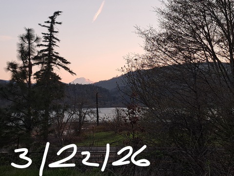
Glenwood this morning
This morning in Glenwood’s a chilly one thanks to clear sky, light wind, and low humidity. At this time of this writing, Glenwood was impressively chilly with 21 degrees. Most of the rest of us started today in the 28-32F range with folks above the inversion (Middle Mountain, for example) in the mid 30s. Fun things to do today: corn snow skiing on the mountain, gardening and biking in the valley, and a demonstration in support of immigrants 3pm-4pm at Mercado Guadalajara in Hood River. So far this morning, no ice on the roads (frost is possible, tho, so be careful out there) and no !CE terrorizing our community.
Today’s Gorge weather forecast
Today’s morning weather will be sunny for all! They can try and take our freedoms, they can try and take our rights, but they can’t take our sunshine! By afternoon, we’ll have high clouds. If a break appears in just the right spot, tonight’s sunset (7:22pm) will be a worthy one. Wind will be light today except near Iwash (dick) Rock and Stevenson, where the wind peaks at 15-20mph midday. High temps range from the upper 50s (west) to 60F (The Dalles) and 66F (Pasco).
Monday’s Gorge weather forecast
Warmer air aloft combines with a few high clouds for a Monday that’s warmer than Sunday. Glenwood: probably sub-freezing. The rest of us: probably mid-30s. Clouds increase during the day, but temps still make it to 60-63F. After a calm start, west wind builds to 10mph between Stevenson and The Dalles in the afternoon.
Extended Gorge weather forecast
There’s more to talk about in Tuesday’s forecast. We start with a warm morning – mid 40s. Clouds stick around all day. Rain arrives to the western Gorge, west of Hood River, by 8am. Starting around 11am, patchy drizzle (or just sprinkles) is expected all the way to Idaho. Commuters: expect heavy rain west of Hood River from 11am to 8pm. Wind will be light/variable most of the day. After sunset, strong westerlies sweep through the Gorge with the strongest wind likely to be near Viento. High temps range from 56F to 61F, warmest east of Rufus.
Dry weather returns on Wednesday and sticks around through late next weekend. Temps bounce around during the week and climb to 60+ starting next Friday. From Sunday on, uncertainty is quite high, so I’ll leave you here for now. Safe travels. -TATAS
HEY! DON’T STOP READING! Is this community-focused forecast helpful to you? It sure is! It takes me a couple hours a day to write. Please join your friends and neighbors in contributing to keep it going. Venmo: @thegorgeismygym PayPal: twomirrors@gmail.com USPS: Temira / PO Box 841 / Hood River, Oregon 97031 You can test out the forecast subscription for a few days for free by signing up below. Easy! Do it!
JONES BEACH, SAUVIE ISLAND, & COAST FORECAST
ON WINTER VACATION UNLESS DESPERATELY NEEDED.

Leave a Reply