

MT HOOD SNOW FORECAST

QR codes and links for end-of-season tips – thank you!!!
Cash/check: Temira – PO BOX 841 – Hood River, Oregon 97031


Hey skiers and snowboarders! Last day for Meadows is today. Timberline will keep it going, which means you T-Line passholders have a shot at a pow day on Wednesday! After that, it’s probably time to end the snow forecast for the season.
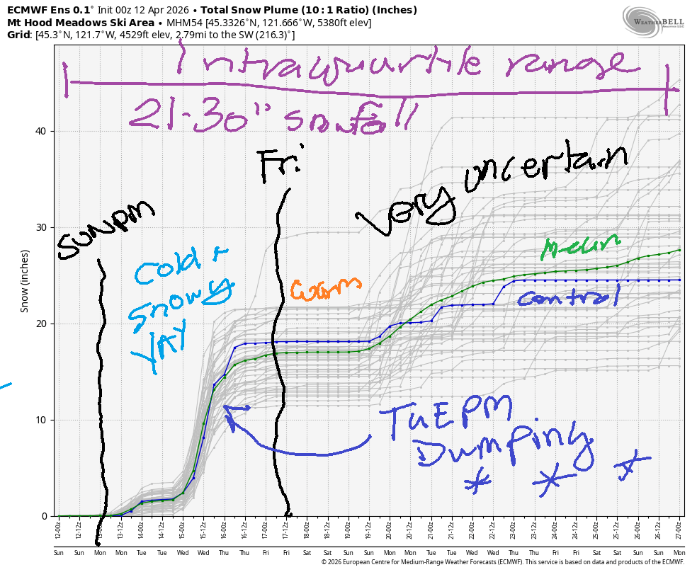
Short term Mt Hood snow forecast
Today on Mt Hood, we’ll have a system moving in from the south. The snow level will be around 6000′ in the morning, 5500′ in the afternoon, and 4500′ after midnight. It’s spring, and lapse rates make a difference; it’s possible we’ll see wet snow rather than rain. UPDATE: it was snowing at the top of Mt. Hood Express at 7:40am. During the day, we’ll see 0.3” to 0.5” water equivalent (WE) for up to an inch of new at 5000′ and a few inches of new way up high. Overnight, another 0.4” WE is forecast for 1-3” at 5000′ and more up high. Wind will be SSW 5-10 early, NW 20-25 in the afternoon, and WNW 35-40 after midnight. Snow surface: refrozen granular down low. Mungy granular mixed with an inch of new up high.
Monday starts with orographic snowfall, turns sunny in the afternoon, and turns cloudy again overnight. The snow level will be 5000′ early, 3500′ in the afternoon, and down around 2000′ overnight. About 0.2” WE is forecast prior to the sky clearing. Call it 1-2” new at 5000′. Wind will be WNW 35-40 early, W 25 in the afternoon, and W 20-25 overnight.
Extended Mt Hood Snow Forecast
Tuesday starts cloudy. Snow starts mid afternoon and ramps up to full-on blizzard conditions overnight. About time! The snow level will be around 2000′ early, 3500′ in the afternoon, and as low as 1000-1500′ overnight. About 0.1” WE is forecast in the afternoon for an inch of new. Overnight, up to 1.1” WE is forecast for 10-13” new snow. Given the wind, we could see a bit more! Wind will be W 20-25 early, WSW 40-45 in the afternoon, W 55 in the evening, and WNW 30-35 after midnight.
Wednesday will be a pow day! The snow level will be around 1500′ all day and will fall to 1000′ overnight. About 0.2” WE is forecast during the day for a couple inches of new. Same overnight. A break in the weather mid-afternoon may bring a period of sun. Wind will be WNW 30-35 in the morning, WNW 25-30 in the afternoon, and NW 20-25 after midnight.
Clear, chilly weather is forecast on Thursday when the freezing level tops out around 3000′. Friday also looks chilly and sunny. After that: uncertainty increases. Next chance of precipitation is late next weekend. That’s probably going to be rain, but cool enough temps for snow are within the range of possible outcomes. Enjoy the last day of Meadows today, everyone!
GORGE WIND FORECAST
If you’re still seeing yesterday’s and it’s after 9am, try opening this in an incognito window
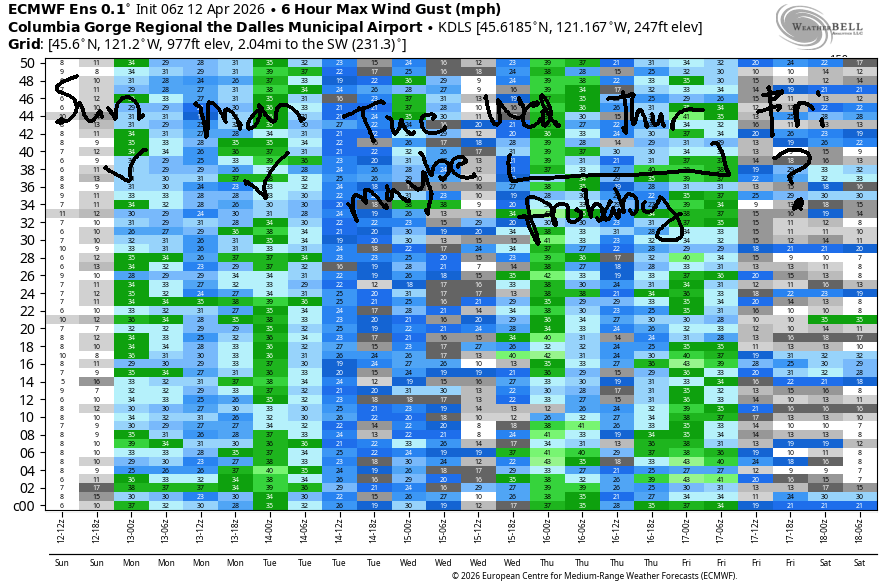
SHORT-TERM gorge wind forecast
Hi friends! Active weather this week gives us several chances for west wind. The best day is likely to be Monday or perhaps Wednesday or Thursday following the passage of a strong cold front.
Sunday brings a weather system through the Gorge, but it’s not the right kind of weather system for epic conditions. The day starts calm with very light onshore pressure gradients. As this weather system approaches mid-morning, westerlies rise to gusty 15-18mph from Stevenson to Arlington. After 2pm, the Avery-Hermiston zone climbs to gusty 25-28mph while the Stevenson-Doug’s zone falls to 13-16mph with rain. Rain is also possible out in the desert and could tamp down wind speed if the heavier rain moves far enough north. It’s a bit of a low-probability day. River flow over the last 24 hours was 157-225kcfs, river temp is 50.0F, and high temp forecast is 61F for Hood River and 66F out in the desert with rain.
RIVER FLOW FOR SITES BETWEEN AVERY (EAST OF THE DALLES) AND RUFUS: CLICK HERE FOR JOHN DAY DAM FLOW.
RIVER FLOW FOR SITES BETWEEN STEVENSON AND DOUG’S BEACH (WEST OF THE DALLES): CLICK HERE FOR THE DALLES DAM FLOW

LONGER-TERM gorge wind forecast
Monday sees a weak system move inland. Areas west of Mosier (or Lyle or The Dalles) stay cloudy all day. You’ll find 18-22mph early from Stevenson to the Hatch, but those areas will likely drop mid-morning. Out east, the wind starts in the upper 20s and rises to 28-32mph from Avery to Hermiston. It’s possible we’ll see 31-34mph from Philippi Canyon to Threemile Canyon in the afternoon. High temp: 57F in Hood River and 68F in Hermiston.
Tuesday sees a strong cold front approaching. Wind starts at less than 10mph west of The Dalles and 13-16mph from The Dalles to Arlington. Afternoon wind rises to 22-25mph from Avery to Arlington. Stevenson-Viento climb late afternoon to the mid 20s ahead of the approaching weather system. Will the Hatch join? Maybe, but it’ll be super up-and-down if it does!
Wednesday and Thursday both have at least some potential for strong westerlies, probably out in the desert. Beyond that, uncertainty is too high to make any worthy forecasts. Have fun out there, folks. Hope to see you on the Nch’i Wana soon!

BARE BONES HOOD RIVER WEATHER FORECAST
Clouds this morning give way to rain midday. Temps start in the low 40s and rise to the low 60s. Calm wind early. Moderate westerlies later. 93% chance of rainbows. Monday will be cloudy then mostly cloudy with a few intermittent sprinkles. Temps start in the mid 40s and rise to the upper 50s. Moderate westerlies. 87% chance of rainbows. Tuesday will be cloudy then rainy. Temps start in the low 40s and rise to the mid 50s. Moderate westerlies. 98% chance of rainbows.
TEMIRA’S AWESOME TRAVEL ADVISORY SERVICE
HYPERLOCAL WEATHER FORECAST FOR THE COLUMBIA GORGE
THE DALLES, HOOD RIVER, WHITE SALMON, TROUT LAKE, STEVENSON, CASCADE LOCKS, PARKDALE, ODELL, HUSUM, BZ, MILL A, WILLARD, GOLDENDALE, RUFUS, ARLINGTON, boardman
Good morning, neighbors! Fun stuff coming up in the next week or so: rain, snow, frost, wind, blizzard conditions on the passes Tuesday night… must be spring in the Gorge!
Glenwood this morning
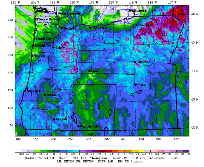
This morning kicked off with a serene sunrise, probably prettiest in Glenwood where it was 37 degrees. Rain is headed this way from the south, and models have upped the predicted rain totals. See image.
Today’s Gorge weather forecast
Since today’s system is coming from the south, there won’t be a rain shadow from the Cascades. The farther south you are, the more rain you’ll receive. South Wasco, Gilliam, and Sherman Counties along with Parkdale could see up to 1/2”. Ditto for areas between Troutdale and Cascade Locks. Farther east along the 84/14 corridor and to the north: 0.1” to 0.25” with a few select areas getting more (see image). Temps max out around 60F (west), 63F (The Dalles), and 66F (The Desert). After a calm start, the wind picks up to 15mph west of The Dalles and 20-30mph east of The Dalles all the way to Hermiston. Heading to/from Portland? Heaviest rain for that drive will be 2pm to 8pm.
Monday’s Gorge weather forecast
Overnight into Monday, this system clears the area and another one loads up from the north. Sprinkles extend, on-and-off, as far east as Hood River. To the east: dry. After a mid-40s, breezy start (no frost), temps rise to 57F (west), 60F (The Dalles), and 68F (Hermiston). The temp gradient combines with an approaching weather system and high pressure offshore for west wind at 15-20mph west of The Dalles and 30-35mph to the east.
Tuesday’s Gorge weather forecast
A cloudy start Tuesday morning should keep us frost-free (40 degrees or so) despite temps at 5000′ being -3C. By mid to late morning, rain arrives. By 2pm, it reaches as far east as Lyle, and overnight, it extends to The Dalles. Driving to or from the metro area? Rain will be heavy west of Viento from 5pm Tuesday through 5am Wednesday. In other words, the evening commute will… suck. At least it will be light out! Wind on Tuesday will be under 10mph west of The Dalles until early evening, when it’ll ramp up to 20-30mph. To the east of The Dalles, the wind rises to 20-25mph. High temps: 54F-61F.
Wednesday’s Gorge weather forecast
As this system swings through, temps fall. Wednesday morning sees the snow level as low as 1500-2000′ with windy conditions and partly cloudy sky. This could give us sub-freezing temps in High Prairie, Snowden, Glenwood, and possibly Parkdale and Trout Lake. However… it’s likely to be cloudy, which means we’ll be seeing… SNOW FLURRIES in those locations! A few showers (down low) or flurries (up high) linger during the day. Temps max out in the 51F-57F range.
Extended Gorge weather forecast
Thursday morning looks concerning from a frost perspective: we’re expecting mostly clear sky, light NW wind, and 850mb temps at -5C to -6C. Unless something changes, sub-freezing temps are almost certain above 1000, and frost is likely down to the river in any locations that are calm. We’ll look closer as we get closer. Frost is also possible on Friday, but the intensity will be less. Warmer temps are forecast for the weekend with a chance of rain returning on Sunday.
That’s all I’ve got for you today. Gotta go get some garden stuff done prior to the rain arriving. Safe travels. -TATAS
HEY! DON’T STOP READING! Is this community-focused forecast helpful to you? It sure is! It takes me a couple hours a day to write. Please join your friends and neighbors in contributing to keep it going. Venmo: @thegorgeismygym PayPal: twomirrors@gmail.com USPS: Temira / PO Box 841 / Hood River, Oregon 97031 You can test out the forecast subscription for a few days for free by signing up below. Easy! Do it!
JONES BEACH, SAUVIE ISLAND, & COAST FORECAST
ON WINTER VACATION UNLESS DESPERATELY NEEDED.

Leave a Reply