

MT HOOD SNOW FORECAST

Hey skiers and snowboarders! We’re down to the last couple weeks of ski and snowboard season. Get out there and get yourself some before it’s gone! For the next week or so, here’s what we’re expecting: a little snow this afternoon (it’s Sunday) followed by sunshine Monday, clouds on Tuesday, and moderate to heavy snowfall Wednesday into Thursday. Beyond that, a few warmer days are forecast, and beyond next weekend, ensemble uncertainty is too high to make predictions.
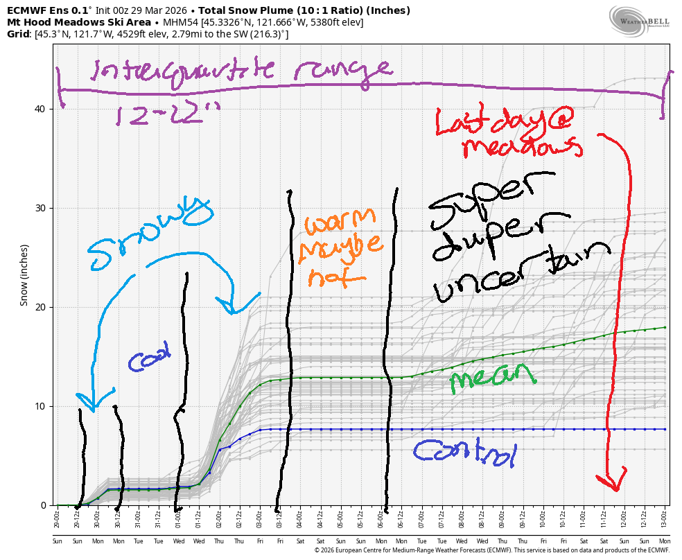
Short term Mt Hood snow forecast
Sunday’s Mt Hood weather starts out cloudy. Snow is forecast to arrive mid-afternoon. The snow level will be around 3500′ all day, and it’ll fall to 1000′ or less under clearing sky overnight. About 0.2” water equivalent (WE) is forecast. That’ll give us a couple inches of new snow, enough to brighten up the slopes. Wind will be W 15 this morning, W 25 this afternoon, W 35 this evening, and N 15 after midnight. Max temps at 5000′ will be in the low-mid 30s.
Monday looks sunny in the morning with a few high clouds in the afternoon. The free air freezing level starts around 0-1000′, rises to 2500′, and falls back to 0-2000′ (depends on location and cloud cover) overnight. Temps max out in the upper 20s to low 30s at 5000′. Wind will be N 15 in the morning, E 10 for most of the day, and variable to 15 after midnight.
Extended Mt Hood Snow Forecast
Tuesday starts high overcast. Snow arrives in the evening. The free air freezing level will be around 2000′ early, and the snow level will be 4000-4500′ when the snow arrives. We’re expecting about 0.3” WE overnight for about 3” new snow. Wind will be variable to 15 in the morning, W 10 in the afternoon, and SSW 15-25 overnight. Temps max out around 32-34F at 5000′.
Heavy snowfall is forecast on Wednesday. Ensembles call for somewhere between 0.75” and 1.2” WE, with the GFS deterministic more optimistic than that. Peak snowfall will be Wednesday daytime when half a foot or snow or more is likely with the snow level around 4000′. Lighter snowfall continues into Thursday with the snow level dropping to 2000-2500′. Wind will be moderate on Wednesday – SW 20-40mph, and it won’t be too much stronger on Thursday. Lifts, other than the highest, most exposed lifts, should run. Sunshine returns on Friday and is likely to stick around through the weekend with above-freezing temps. I’ll leave it there for now. See you on the snow soon!
Was that helpful? I knew it was! Guess what? All of this crucial work – from your personal wind and snow reports to the invaluable TATAS updates – is made possible by my relentless efforts. Maintaining this labor of love isn’t easy. Each daily forecast takes hours. Website hosting, weather model access, and back-end admin work takes time and money. That’s where you come in.
YOUR CONTRIBUTION MAKES A DIFFERENCE
- SUPPORT ACCURATE, HYPER-LOCAL WEATHER FORECASTING
- ENABLE ACCESS FOR ALL, EVEN THOSE WITH LESS MEANS
- SUPPORT A COOL HUMAN WHO WORKS HARD SO YOU CAN PLAY
Take a moment to click one of the buttons below. Donate $19.99 or more (how much does this forecast enhance your life?) and get the email in your inbox. Whether it’s a renewing subscription (auto-renew) or a one-time donation, every contribution makes a real difference. Help me keep this labor of love alive, so we can all continue playing, commuting, and living in the Gorge with peace of mind and the best weather forecasts possible. Thank you!


Hood River, Oregon 97031


GORGE WIND FORECAST
If you’re still seeing yesterday’s and it’s after 9am, try opening this in an incognito window
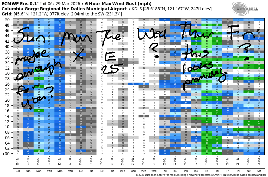
SHORT-TERM gorge wind forecast
Hi friends! Active weather continues today, Sunday, for another round of gusty, up-and-down westerlies. Easterlies are forecast for Monday and Tuesday as high pressure takes over. More active weather on Wednesday and Thursday gives us a shot at gusty westerlies, probably out east.
Sunday started with pressures of 30.12/30.07/30.04 for onshore gradients prior to dawn at 0.05 and 0.03. We’re waiting for an approaching cold front to kick off the wind for us today. That happens late morning – we’ll see Stevenson to Mosier jump to gusty 16-19 (maybe a touch more, briefly) with 11-14 from Lyle to Rufus. After 2pm, areas from Avery to Threemile rise to gusty 24-27. If the cold front moves through early enough, before dark, the Hatch will jump to gusty 20-23 while the desert rises to gusty 26-29. It’s unlikely that will happen early enough, and it’s likely the strongest, steadiest wind will be wasted on the dark hours. River flow over the last 24 hours was 231-274kcfs (250-274kcfs at Rufus), river temp is 47.5F, and high temp forecast is 53F and cloudy in the west with near 60F and clouds out east.
RIVER FLOW FOR SITES BETWEEN AVERY (EAST OF THE DALLES) AND RUFUS: CLICK HERE FOR JOHN DAY DAM FLOW.
RIVER FLOW FOR SITES BETWEEN STEVENSON AND DOUG’S BEACH (WEST OF THE DALLES): CLICK HERE FOR THE DALLES DAM FLOW

LONGER-TERM gorge wind forecast
Monday starts nearly calm. Easterlies rise to 15-20mph at Iwash/Rooster and Stevenson midday. High temp: 55F and full-on sunny.
Easterlies persist on Tuesday morning thanks to a chilly start in the desert. Early wind will be 25mph at both Iwash and Stevenson. By late morning, the wind falls to 15-20mph at Stevenson and turns light/variable at Iwash. Afternoon brings calm wind to Iwash and westerlies at 10mph between Stevenson and the Hatchery. High temp: 58F with increasing clouds.
A cold front is slated to move through on Wednesday with lots of rain. This doesn’t bode well for the wind. From this far out, it appears we’re looking at gusty 20-25mph west wind in the eastern Gorge. When the weather system clears the area on Thursday, we could end up with a stronger day. Beyond that: way too much uncertainty to be making even educated guesses. Hope to see you on the Nch’i Wana soon!

BARE BONES HOOD RIVER WEATHER FORECAST
Cloudy this morning. Drizzly this evening. Temps start in the low 40s and rise to the low 50s. Light to moderate westerlies. 56% chance of rainbows. Monday will be mostly cloudy then clear. Temps start in the low 30s and rise to the mid 50s. Calm wind early. Light easterlies later. No rainbows. Tuesday will be sunny then cloudy. Temps start in the low 30s and rise to the upper 50s. Light easterlies then light westerlies. No rainbows.
TEMIRA’S AWESOME TRAVEL ADVISORY SERVICE
HYPERLOCAL WEATHER FORECAST FOR THE COLUMBIA GORGE
THE DALLES, HOOD RIVER, WHITE SALMON, TROUT LAKE, STEVENSON, CASCADE LOCKS, PARKDALE, ODELL, HUSUM, BZ, MILL A, WILLARD, GOLDENDALE, RUFUS, ARLINGTON, boardman
Good morning, neighbors! Good showing yesterday, folks! Standing up and protesting is a good start, and it’s not enough. Vote with your dollars. Keep using your voice between protests. Speak up when you hear others expressing bigotry, ill-will, or intolerance. Stand for kindness.
Glenwood this morning
Guess who’s being kind this morning? You thought I was going to say “Glenwood”, didn’t you? Glenwood (32F) is being kind, but I was really going to mention Ma Nature. Looks like almost everyone (exceptions: Glenwood and maybe Trout Lake) is above freezing this morning. Next chance of frost: Monday morning and Tuesday morning.
Poop report
(I have to poop now)
(I pooped)
Today’s Gorge weather forecast
Today (Sunday) brings overcast sky with temps generally around 40F to start. Afternoon brings low 50s to the west side, upper 50s near The Dalles, and 60F way out in the desert. Drizzle arrives to Cascade Locks around 2pm and to Rowena by 5pm. Drizzle finishes up around 8pm, about when I go to bed. Wind today will be light westerly early, 15mph from Stevenson to The Dalles early afternoon, and 25mph east of The Dalles from mid-afternoon into the evening, when it will be quite windy for a few hours before settling down after midnight.
Monday’s Gorge weather forecast
Overnight, the sky (mostly) clears, the wind (mostly) stops, stars sparkle, and the vastness of the universe sucks away the heat, especially right near the ground. Result: frost, thanks to 850mb temps near -6C. Upper valley: 27-30. Glenwood: 20-23. River level: 31-34. Our only hope is the slight possibility of some lingering mid-level clouds keeping some of the heat in overnight. If we wake up to clouds, expect 30-33F above 1000′ and warmer temps below. For the rest of Monday, we’ll have sunshine. Temps rise to the mid 50s. Wind turns easterly at 15-20mph near Iwash (dick) Rock and Stevenson with easterlies at 10mph in the hills. Annoying if you’re trying to spray, so do it early.
Tuesday’s Gorge weather forecast. Actually, this is the extended Gorge weather forecast, not just Tuesday.
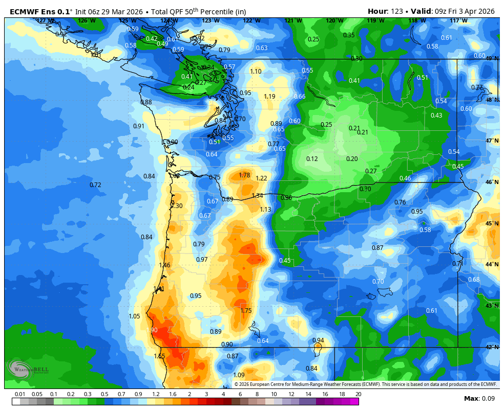
Tuesday starts clear. While temps aloft will be warmer, the combo of clear sky and low humidity puts us at risk for frost again. By afternoon, we’ll be cloudy. Wind: E 25mph in the usual spots with morning easterlies to 10mph in the hills and light westerlies in the afternoon. Rain arrives late Tuesday night and continues through Thursday morning. Heaviest rain will be Wednesday daytime (impacting your drive to/from the city). See 50th percentile precipitation image for forecast rain amounts.
Sunshine returns on Friday. Temps warm through the weekend. Uncertainty skyrockets late next weekend, so this is the end of the forecast for today. Safe travels. -TATAS
HEY! DON’T STOP READING! Is this community-focused forecast helpful to you? It sure is! It takes me a couple hours a day to write. Please join your friends and neighbors in contributing to keep it going. Venmo: @thegorgeismygym PayPal: twomirrors@gmail.com USPS: Temira / PO Box 841 / Hood River, Oregon 97031 You can test out the forecast subscription for a few days for free by signing up below. Easy! Do it!
JONES BEACH, SAUVIE ISLAND, & COAST FORECAST
ON WINTER VACATION UNLESS DESPERATELY NEEDED.

Leave a Reply