

MT HOOD SNOW FORECAST

Hey skiers and snowboarders! It’s looking like Mt Hood ski season is just around the corner, but it’s going to be a wild ride to get there. A mix of rain and snow Monday and Tuesday (mostly rain) gives way to heavy snowfall Wednesday followed by another round of (probably) very heavy rain Thursday. You may recall that yesterday’s Mt Hood snow forecast model runs had the possibility of Thursday rain around 20% or less. Unfortunately, the GFS has jumped on board with the Pineapple scenario after insisting for days that temps at 5000′ would stay below freezing. After that Thursday system, though, there’s hope – all the ensemble members from both the GFS and Euro are insisting on cold temps and zero rain for the extended period.
Not much happens on Sunday. After a clear start, clouds arrive and thicken throughout the day. The free air freezing level (FAF) will be 11,000′ in the morning, 10,000′ in the afternoon, and 9000′ after midnight. Wind will be SW 20-30 all day and SW 30-45 after midnight.
Rain arrives before sunrise Monday and continues all day. Just-cool-enough air filters in to give us mixed precip, then snow, overnight. The snow level falls from 9000′ in the morning to 5500′ in the afternoon to 5000′ overnight. We’ll pick up about 1.0” rain followed by 0.6” water equivalent (WE) mixed precip for 1-4” new snow depending on elevation. Wind: SW 30-45 in the morning, WSW 60 in the afternoon, and a slow fade to WSW 20-25 after midnight.
On Tuesday, the snow level bounces back into the rain zone during the day and crashes downward overnight as a powerful cold front swings through. The snow level will be 5000′ early, 8000′ in the evening, and down to 2000-2500′ after midnight. About 0.3” rain falls during the day. During the transition period (10pm-1am), 0.8” WE is forecast. Call that 2-5” snow. Another 0.4” WE falls as snow prior to 4am Wednesday for 4-5” less-concretey snow. Wind will probably enhance snowfall rates; we’re actually looking at a full-on blizzard: WSW 20-25 in the morning, W 65 (holy moly!) in the evening, and WNW 60 after midnight. If the resorts were open, they wouldn’t be running lifts!
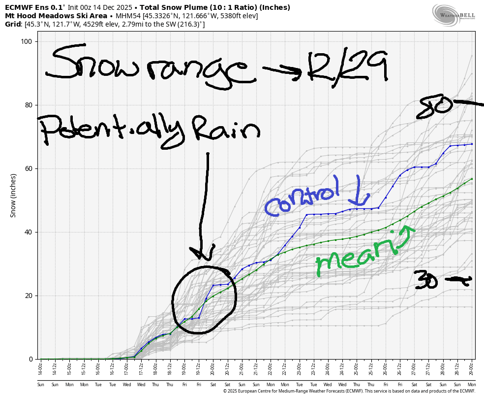
Moderate snowfall, perhaps another half a foot, is forecast on Wednesday with the snow level around 2000′. Light snow continues into Thursday, when we encounter the newly-disappointing next system, which is almost certain to have an extended period of the wrong type of moisture. This is (obviously, given yesterday’s forecast) a rapidly evolving forecast, so we’ll look at it again tomorrow. In the meantime, let’s take a look at some other numbers: the 25th-75th percentile spread for snowfall through next Saturday on Mt Hood is 17-33”. That should be enough to get something open especially given the cold, snowy long-range forecast. OK. Fingers crossed. See ya tomorrow!
Was that helpful? I knew it was! Guess what? All of this crucial work – from your personal wind and snow reports to the invaluable TATAS updates – is made possible by my relentless efforts. Maintaining this labor of love isn’t easy. Each daily forecast takes hours. Website hosting, weather model access, and back-end admin work takes time and money. That’s where you come in.
YOUR CONTRIBUTION MAKES A DIFFERENCE
- SUPPORT ACCURATE, HYPER-LOCAL WEATHER FORECASTING
- ENABLE ACCESS FOR ALL, EVEN THOSE WITH LESS MEANS
- SUPPORT A COOL HUMAN WHO WORKS HARD SO YOU CAN PLAY
Take a moment to click one of the buttons below. Donate $19.99 or more (how much does this forecast enhance your life?) and get the email in your inbox. Whether it’s a renewing subscription (auto-renew) or a one-time donation, every contribution makes a real difference. Help me keep this labor of love alive, so we can all continue playing, commuting, and living in the Gorge with peace of mind and the best weather forecasts possible. Thank you!


Hood River, Oregon 97031


GORGE WIND FORECAST
If you’re still seeing yesterday’s and it’s after 9am, try opening this in an incognito window
First half of the gorge wind forecast
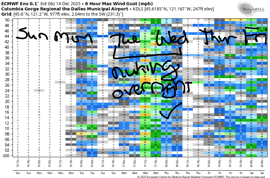
Hi friends! Not much happening today, but we’ll have westerlies of some sort over the next few days. Nuking wind is almost certain overnight Tuesday into Wednesday, but it’s looking like the strongest wind will happen overnight. Still, there should be enough wind on Wednesday to get many of you on the river.
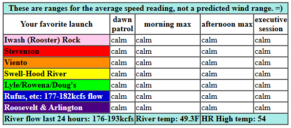
Sunday looks calm all day. River flow over the last 24 hours was 176-193kcfs, river temp is 49.3F, and high temp forecast is 54F under cloudy sky. Monday starts with light east wind. Thanks to an incoming system, westerlies pick up to gusty 17-20mph (ish) from Stevenson to Viento and near Arlington. Low 20’s (more out east) are possible in the evening, but probably not before sunset. High temp: 59F with rain. Tuesday starts calm. Westerlies rise to 15-18mph midday from Stevenson to Viento.
RIVER FLOW FOR SITES BETWEEN AVERY (EAST OF THE DALLES) AND RUFUS: CLICK HERE FOR JOHN DAY DAM FLOW.
RIVER FLOW FOR SITES BETWEEN STEVENSON AND DOUG’S BEACH (WEST OF THE DALLES): CLICK HERE FOR THE DALLES DAM FLOW

The Rest Of The GORGE WIND FORECAST
Overnight Tuesday, probably after 10pm, the wind goes nuclear all the way from the Multnomah Falls area out into the far eastern desert. Westerlies linger into Wednesday, probably in the mid 20s, but we’ll check that out more closely as we get nearer. That’s enough for now. Hope to see you on the Nch’i Wana soon!
BARE BONES HOOD RIVER WEATHER FORECAST
Nothing this morning. Cloudy later. Temps start in the upper 30s and rise to the mid 50s. Calm wind. No rainbows. Monday will be rainy. Temps start in the mid 40s and rise to the upper 50s. Calm wind early. Moderate westerlies later. 99% chance of rainbows. Tuesday will be rainy in the morning, briefly dry, and then rainy again. Temps start in the mid 40s and rise to the mid 50s. Calm wind early. Light westerlies later. Nuking wind overnight. 99% chance of rainbows.
TEMIRA’S AWESOME TRAVEL ADVISORY SERVICE
HYPERLOCAL WEATHER FORECAST FOR THE COLUMBIA GORGE
THE DALLES, HOOD RIVER, WHITE SALMON, TROUT LAKE, STEVENSON, CASCADE LOCKS, PARKDALE, ODELL, HUSUM, BZ, MILL A, WILLARD, GOLDENDALE, RUFUS, ARLINGTON, boardman
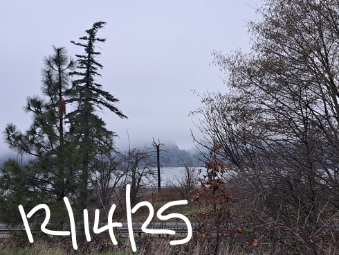
Good morning, neighbors! Just when you thought the Nothing couldn’t get any worse, it dropped down almost to river level. Given the fact that it was glowing pink at sunrise, there must be sunshine above it. I hope the vast majority of you are up there soaking up Vitamin D! Get it while you can. We’re looking at a very active weather week with rain, wind, and even some snow at 2000′ and above.
Glenwood this morning and today’s Gorge weather forecast
But before we jump into all that… let’s visit our friends in Glenwood. They appear to be above the inversion this morning. Last I checked, it was 54F there and 37F in Hood River, where the Nothing enveloped the Heights and White Salmon and Underwood disappeared from view. That Nothing should burn off today, but by the time it does, we’ll have clouds aloft. Temps max out in the mid 50s all the way from Stevenson out into the desert. Wind: calm.
Monday’s Gorge weather forecast
Rain arrives sometime after midnight and makes it as far east as Mosier on Monday morning. Western Gorge: full of puddles and unpleasant to drive 1am-7pm. East of Mosier: probably dry all day. After a mid-40s start, we’ll move into full-on Pineapple mode: the high temp forecast is 59F on the west side and 62F out in the desert. Hood River’s record high for 12/15 is 60. Hood River’s record high-low for 12/15 is 46. Both of these are in jeopardy and are indications of just how ridiculously warm it’s going to be. Wind: light easterly early followed by west wind at 15-20mph west of Hood River and east of Rufus with lighter wind in between. Rainbows: yes. Snow in the mountains: no.
Tuesday’s Gorge weather forecast
Rain continues west of The Dalles for much of Tuesday. A brief break mid-afternoon gives way to a stronger, wetter system on Tuesday evening. That one will F up your commute between the metro area and the Gorge. Morning temps: mid 40s. Afternoon: mid 50s to the west and nearly 60 to the east. More interesting and potentially dangerous conditions manifest Tuesday night as a powerful cold front sweeps through. West wind responds by rising to 30-40mph (stronger gusts) all through the Gorge, all the way out to Arlington. Given the saturated soils, downed trees are possible along the 84/14 corridor overnight, so do be careful out there.
Extended Gorge weather forecast
Accompanying this system is much colder air; the snow level falls from 8000′ to 2000′-2500′ overnight into Wednesday morning. Add in pass-level wind at 50-60mph and moderately heavy snowfall for full-on blizzard conditions on the passes Tuesday night into early Wednesday. Precipitation lessens on Wednesday, but the snow/freezing level will remain in the 2000-2500′ zone. We can’t rule out a little snow for some of us here in the Gorge. Showers and rainbows continue on Wednesday west of Rowena with high temps in the mid 40s.
Next up: a potentially impactful super-wet system on Thursday into early Friday with unfortunately-elevated snow levels. This is going to drive river levels up again. As of yesterday, models were calling for lesser precip and much colder temps with this system. This morning, they said, “PSYCH!”. After this system, though, models suggest we’ll finally settle into our usual cold, wet, mountain-snow winter weather, messy-pass-driving for the rest of December. Maybe it’s finally time to put your snow tires on! Safe travels. -TATAS
HEY! DON’T STOP READING! Is this community-focused forecast helpful to you? It sure is! It takes me a couple hours a day to write. Please join your friends and neighbors in contributing to keep it going. Venmo: @thegorgeismygym PayPal: twomirrors@gmail.com USPS: Temira / PO Box 841 / Hood River, Oregon 97031 You can test out the forecast subscription for a few days for free by signing up below. Easy! Do it!
JONES BEACH, SAUVIE ISLAND, & COAST FORECAST
ON WINTER VACATION UNLESS DESPERATELY NEEDED.
