

GORGE WIND FORECAST
If you’re still seeing yesterday’s and it’s after 9am, try opening this in an incognito window
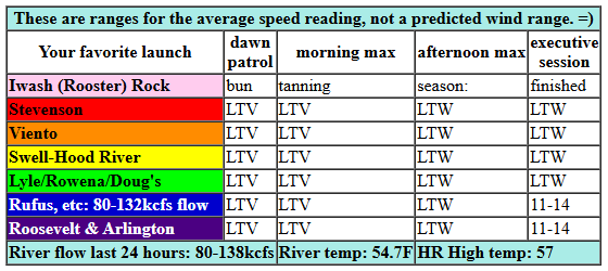
today’s gorge wind forecast
Hi friends! It’s Sunday, and not much is on the schedule today for wind. We do have a shot at westerlies late on Monday and especially during the day on Tuesday. Sunday, tho… not much: calm this morning with a shot at 11-14mph west wind between Avery and Arlington mid afternoon.
RIVER FLOW FOR SITES BETWEEN AVERY (EAST OF THE DALLES) AND RUFUS: CLICK HERE FOR JOHN DAY DAM FLOW.
RIVER FLOW FOR SITES BETWEEN STEVENSON AND DOUG’S BEACH (WEST OF THE DALLES): CLICK HERE FOR THE DALLES DAM FLOW

tomorrow’s gorge wind forecast
On Monday, we have a post-frontal setup with offshore high pressure. Modes suggest a light wind start as the front moves through. We then see a slow build to 18-22mph from Stevenson to Doug’s. High temp: 54F. Water temp: 54.7F.
extended Gorge wind forecast

Looking at Tuesday: high pressure lingers off the California coast, and another weather system approaches from the northwest. The day starts with 17-20mph from Viento the Hatch with 11-14mph from Hood River to Avery. Models take the westerlies to 20-23mph from Stevenson to Doug’s early afternoon with 17-20mph (maybe) from Avery to Rufus. The wind holds into the afternoon. High temp: 51F under increasingly cloudy sky with dry weather. Model agreement falls apart on Wednesday and into the latter half of next week, so I’ll leave it there for now. Have an awesome day!
Was that helpful? I knew it was! Guess what? All of this crucial work – from your personal wind and snow reports to the invaluable TATAS updates – is made possible by my relentless efforts. Maintaining this labor of love isn’t easy. Each daily forecast takes hours. Website hosting, weather model access, and back-end admin work takes time and money. That’s where you come in.
YOUR CONTRIBUTION MAKES A DIFFERENCE
- SUPPORT ACCURATE, HYPER-LOCAL WEATHER FORECASTING
- ENABLE ACCESS FOR ALL, EVEN THOSE WITH LESS MEANS
- SUPPORT A COOL HUMAN WHO WORKS HARD SO YOU CAN PLAY
Take a moment to click one of the buttons below. Donate $19.99 or more (how much does this forecast enhance your life?) and get the email in your inbox. Whether it’s a renewing subscription (auto-renew) or a one-time donation, every contribution makes a real difference. Help me keep this labor of love alive, so we can all continue playing, commuting, and living in the Gorge with peace of mind and the best weather forecasts possible. Thank you!


Hood River, Oregon 97031


MT HOOD SNOW FORECAST

Hi skiers and snowboarders! Your Mt Hood snow forecast doesn’t contain much, at least not until the 24th, when ensembles hint at colder AND wetter weather – prior to that, it looks like we’ll only have one of those at a time.
Sunday will be high overcast to start then rainy from mid-afternoon on. The snow level will be 11,000′ early and will eventually fall to 6500′. Precip: 0.1” rain during the day, 0.1” rain overnight. Wind will be light southerly in the morning and SW 10-20 from mid-afternoon on through the night. A trace of rain is forecast on Monday but models stretch that trace out over the entire day and night. The snow level will be 6500′ all day and will fall to 5500′ overnight, but the precip will pretty much be done by then. Wind: SSW 5-15. Tuesday will be dry and partly cloudy after a brief shot of mixed precip early. The free air freezing level will be 5500′ all day and will fall to 4000′ after midnight. Wind: S 5-10 early, NW 20-25 in the afternoon, and N 10 overnight.
Looking deeper into the future… we start to see less model agreement towards the end of next week. Ensembles hint at some sort of weak to moderate atmospheric river with temps probably remaining a bit too warm for snow at 5000′ through next week. Models then like the idea of cooler temps, potentially combined with moisture, for a building snowpack starting around the 24th. Fingers crossed! Hope to see you on the snow soon!
BARE BONES HOOD RIVER WEATHER FORECAST
Nothing today becoming drizzly mid-afternoon. Temps start in the upper 40s and rise to the upper 50s (maybe). Calm wind this morning. Light westerlies later. 1% chance of rainbows. Monday will have early drizzly then a few showers. Cloudy early. Partly cloudy later. Temps start in the mid 40s and rise to the mid 50s. Calm wind early. Moderate westerlies later. 94% chance of rainbows. Tuesday will be partly cloudy then cloudy. Dry. Temps start near 40 and rise to the low 50s. Moderate to moderately strong westerlies. No rainbows.
TEMIRA’S AWESOME TRAVEL ADVISORY SERVICE
HYPERLOCAL WEATHER FORECAST FOR THE COLUMBIA GORGE
THE DALLES, HOOD RIVER, WHITE SALMON, TROUT LAKE, STEVENSON, CASCADE LOCKS, PARKDALE, ODELL, HUSUM, BZ, MILL A, WILLARD, GOLDENDALE, RUFUS, ARLINGTON, boardman

Good morning, neighbors! It’s Sunday, and we have a heck of a Nothing cloud hanging along the Nch’i Wana this morning – it looks like, well, it looks like November out there! Other clouds join the fun later and bring some rain into the Gorge. The tail end of that system gives us lingering drizzle Monday and then dry weather Tuesday and Wednesday. Most of our ensemble friends like the idea of more rain towards the end of the week. I mean, what do you expect? It’s November. It’s wet.
Glenwood this morning
Looking around the region this morning… roads seem to be clear of ¡ce so far! Up in Glenwood, it’s 37 degrees and high overcast. Know what folks are doing up there this morning? No? Neither do I! Perhaps they are searching for the photos of “Trump blowing Bubba”. Now, remember everyone, Mark Epstein clarified that this isn’t former president Bill Clinton, but he did not deny there are photos of Trump blowing SOMEONE ELSE named Bubba. Perhaps that’s the name of JD Vance’s couch?
Today’s Gorge weather forecast
Today’s weather just gets cloudier and cloudier (GREAT DAY FOR SEARCHING THE EPSTEIN DOC DATABASE), and eventually the clouds will collapse under the weight and pee on us. That happens around the time the Seahawks game starts. PERFECT! Rain makes it to Underwood around 1pm and as far east as Biggs and even the Tri-Cities by 4pm. Temps max out in the upper 50s across the lowlands today. Wind: not much, but maybe 10-15mph east of The Dalles later today.
Monday’s Gorge weather forecast
Showers linger into Monday morning as far east as Hood River and also out near the One-Two-Three-Cities. After a mostly cloudy start, the sun shakes like a dog, shatters the cloud cover, and leaves us partly cloudy. West wind picks up to20mph between Stevenson and The Dalles. Temps rise to the low 50s (west) and upper 50s (The Dalles into the desert).
Extended Gorge weather forecast
Lingering west wind overnight keeps us partly cloudy (west) and mostly clear (east). Tuesday starts off dry and cool with temps dropping close to freezing away from the Nch’i Wana and holding around 40F near it. Dry weather sticks around all day despite an increase in clouds. Temps rise to the low-mid 50s, and west wind picks up to 20-25mph between Stevenson and The Dalles with 15-20mph near Rufus.
Wednesday will probably be dry and will probably be 50-55 degrees. After that, model agreement falls apart. MOST (but not all) of the models agree on damp weather starting Thursday or Friday and persisting through next week. For this period, the snow level will be above 5000′. If you, like me, prefer to wait until the last minute to put on your snow tires, you can go ahead and keep waiting. Safe travels. -TATAS
HEY! DON’T STOP READING! Is this community-focused forecast helpful to you? It sure is! It takes me a couple hours a day to write. Please join your friends and neighbors in contributing to keep it going. Venmo: @thegorgeismygym PayPal: twomirrors@gmail.com USPS: Temira / PO Box 841 / Hood River, Oregon 97031 You can test out the forecast subscription for a few days for free by signing up below. Easy! Do it!
JONES BEACH, SAUVIE ISLAND, & COAST FORECAST
ON WINTER VACATION UNLESS DESPERATELY NEEDED.
