

MT HOOD WEATHER FORECAST
Hey skiers and snowboarders! Today’s your last chance at spring skiing for a while. Mt Hood weather switches back to winter this evening with up to half a foot of snow. After a break Monday, and dry weather Tuesday morning, snow returns Tuesday night and sticks around on and off through the rest of the week. Models are honing in on a big snowstorm next weekend. I don’t know about you, but I’m looking forward to seeing the snow conditions switch from granular back to powder, packed powder, and hardpack. And I’m really looking forward to seeing snow in the trees again!
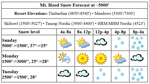
Let’s take a look at Sunday… before I forget, it’s the last night skiing of the season at Meadows. They’re having an end of nights party. Weather today: high clouds and filtered sun most of the day with increasing clouds in the afternoon. Snow starts up around 5pm and continues into the night, heaviest late tonight. The snow level will be 5000′ this morning, 3000′ this evening, and 1500′ after midnight. Temps at 5000′ start at 37F and fall to 25F tonight. About 0.5” water equivalent (WE) is forecast tonight for 4-6” new snow depending on how much orographic (terrain+wind) assistance we get. Wind: SW 20-30 all day, WSW 40-45 this evening, and NW 15-20 after midnight.
A few lingering flurries Monday morning give way to clear sky for several hours. That’s followed by increasing clouds in the afternoon and night. The snow level will be around 1500′ in the morning, 3000′ in the afternoon, and 2000′ after midnight. Temps will be about 25F in the morning and 28F for highs. Wind:NW 15-20mph in the morning, W 10 in the afternoon, and SW 5-10 overnight.
extended mt hood weather forecast
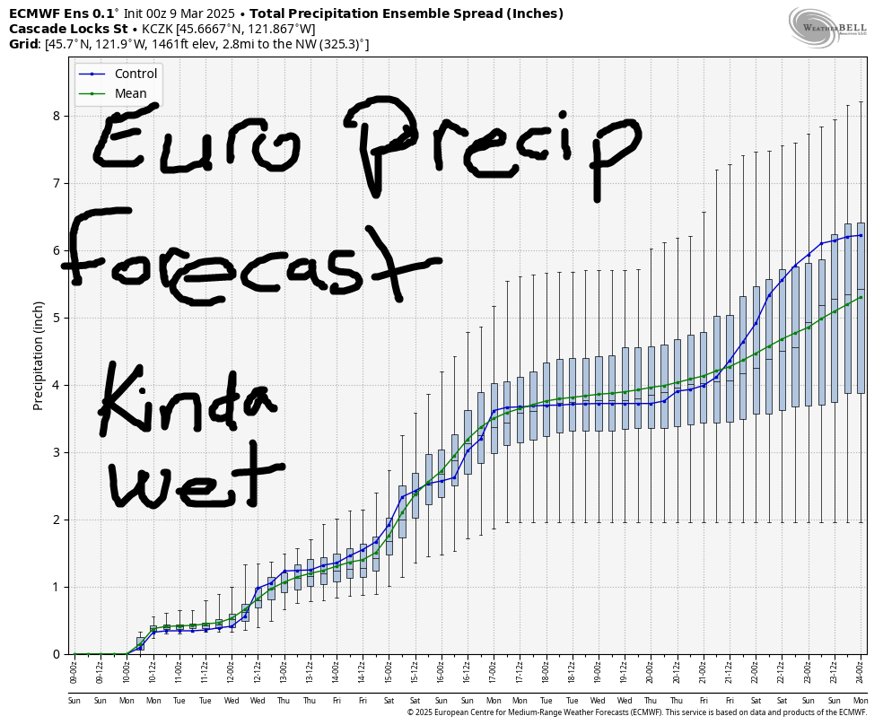
Tuesday starts cloudy. Snow arrives early afternoon and picks up overnight. The snow level will be about 2500′, but may fall as low as 1500′ overnight. Temps will be in the mid to upper 20s at 5000′. Just a trace of snow is forecast in the afternoon. That’s followed by about 0.3” WE overnight for 3” fresh snow of decent quality. Wind: SW 5-10 in the morning, SW 25-30 in the afternoon, and SW 30-35 after midnight. Light snowfall continues Wednesday through Friday. Much heavier precip is in the cards Saturday and Sunday. There’s a chance some of this will come in as mixed precip or even rain, but there’s also quite a bit of snow in the picture. We’ll keep watching it. Have a great day on the snow!
Was that helpful? I knew it was! Guess what? All of this crucial work – from your personal wind and snow reports to the invaluable TATAS updates – is made possible by my relentless efforts. Maintaining this labor of love isn’t easy. Each daily forecast takes hours. Website hosting, weather model access, and back-end admin work takes time and money. That’s where you come in.
YOUR CONTRIBUTION MAKES A DIFFERENCE
- SUPPORT ACCURATE, HYPER-LOCAL WEATHER FORECASTING
- ENABLE ACCESS FOR ALL, EVEN THOSE WITH LESS MEANS
- SUPPORT A COOL HUMAN WHO WORKS HARD SO YOU CAN PLAY
Take a moment to click one of the buttons below. Donate $19.99 or more (how much does this forecast enhance your life?) and get the email in your inbox. Whether it’s a renewing subscription (auto-renew) or a one-time donation, every contribution makes a real difference. Help me keep this labor of love alive, so we can all continue playing, commuting, and living in the Gorge with peace of mind and the best weather forecasts possible. Thank you!


Hood River, Oregon 97031


GORGE WIND FORECAST

Hi friends! Next best chances for west wind are today ahead of an incoming system and Thursday. Today, Sunday, starts of calm with very light onshore gradients. By late morning, the wind rises to 13-16 from Stevenson to Swell. Ahead of incoming rain, we’ll see the wind rise to gusty 17-21 this afternoon from Stevenson to Avery with a shot at 20-23 late afternoon Stevenson-Swell as the system moves inland and and high pressure builds behind it. River flow over the last 24 hours was 74-151kcfs, river temp is 41.90F, and high temp forecast is 60F with increasing clouds and rain this evening.
Monday will be light westerly to start, calm midday, and W 10-13 from Stevenson to Swell in the afternoon. High temp: 53F with clouds. Tuesday looks light and variable, mostly cloudy, and 50 degrees. Wednesday: light/variable. Next chance for strong-enough wind is next Thursday. All the Euro ensemble members have wind in the picture. Not nuking wind, mind you, but more wind than today. Seems a safe bet to pencil it in. Even more active weather is forecast next weekend. If we get lucky, the timing will work out well for a big day as a low moves inland. Keep it in mind, but don’t make plans yet. Hopefully I’ll see you on the river this afternoon!
BARE BONES HOOD RIVER WEATHER FORECAST
High clouds stick around all day. Rain arrives early evening. Temps start in the mid 30s and rise to 60. Calm wind early. Moderate westerlies later. 1% chance of rainbows. Monday will be mostly cloudy with a few sprinkles to start and mostly cloudy later. Temps start in the mid 30s and rise to the low 50s. Light westerlies. 11% chance of rainbows. Tuesday will be mostly cloudy with rain midday. Temps start in the mid 30s and rise to the low 50s. Light and variable wind. 89% chance of rainbows.
TEMIRA’S AWESOME TRAVEL ADVISORY SERVICE
HYPERLOCAL WEATHER FORECAST FOR THE COLUMBIA GORGE
THE DALLES, HOOD RIVER, WHITE SALMON, TROUT LAKE, STEVENSON, CASCADE LOCKS, PARKDALE, ODELL, HUSUM, BZ, MILL A, WILLARD, GOLDENDALE, RUFUS, ARLINGTON, boardman
Good morning, neighbors! Has anyone seen my 2am-3am hour? Because I want it back! Lemme tell you what: combining periM sleep deprivation with the missing hour is unpleasant. And today, the final warm one for a while, is not a day to waste napping! This upcoming week looks cool, showery, and has the potential for a little snow here and there. Things get much more interesting next weekend.
glenwood & TATAS EOOTD
Let’s start the day by checking in with Glenwood. The NWS sensor that’s my go-to is down this morning. A backup on a private network is reading 30 degrees with a dewpoint of 29. TATAS EOOTD: We’re sticking with DST from now on. Switching the clocks does nobody any good. Signed with a Uniball Jetstream 0.7.
sunday
It’s Sunday, and it’s currently dark AF thanks to the clock switch. We’ll have high clouds and light wind this morning, perfect for spraying and tilling: we did a little pumpkin patch tilling yesterday, and the dirt’s plenty dry at my patch. Normally I’m a no-till person, but I like to till the new patch. Anyway… westerlies pick up to 20mph this afternoon between Stevenson and Celilo Village with lighter wind to the east. Rain arrives in Cascade Locks around 5pm, Rowena around 8pm, and Celilo a bit later. Heaviest rain, enough to make for unpleasant driving, will be from 8pm to 11pm west of Hood River. Today’s high temp: 60F, about 7F higher than any day next week. Get out and enjoy it!
monday
That Sunday weather system knocks temps way down on Monday morning. A few snow flurries are possible above 1500′ before things dry out around sunrise. South Wasco and Sherman Counties are likely to see a little drizzle until sunrise. After that: a mostly cloudy day in the west and a partly cloudy day to the east with high temps in the low 50s. Wind: light and variable to start and W 10-15mph in the afternoon, strongest west of Mosier.
tuesday and beyond
Dry, mostly cloudy weather Tuesday morning adds rain in the afternoon as far east as The Dalles. Temps max in the low 50s, and wind will be light and variable. Wednesday looks similar. On-and-off showers are forecast Thursday and Friday. Models call for heavier rain next weekend, but temps are uncertain as of now. Let’s leave it there and pick it up again when I’m better rested. Safe travels. -TATAS
HEY! DON’T STOP READING! Is this community-focused forecast helpful to you? It sure is! It takes me a couple hours a day to write. Please join your friends and neighbors in contributing to keep it going. Venmo: @thegorgeismygym PayPal: twomirrors@gmail.com USPS: Temira / PO Box 841 / Hood River, Oregon 97031 You can test out the forecast subscription for a few days for free by clicking this link: https://subscribepage.io/YhevGc
