

MT HOOD SNOW FORECAST

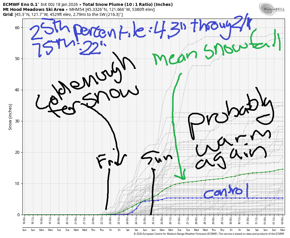
Hey skiers and snowboarders! Sunshine continues on the slopes through at least Wednesday morning. That’s followed by at least a little snow at the end of next week or next weekend. Models then, disconcertingly, call for warmer temps again. I looked at the intraquartile range for snowfall this morning (that’s the 25th to 75th percentile), and it’s slipped to 4.3”-22” through the first of February.
Short term Mt Hood snow forecast
Let’s focus on today first, because it’s going to be a stunning day on our local volcano. Sunshine and nearly calm wind is forecast all day. The free air freezing level holds above 10,000′ all day with temps rising to 40-50F degrees depending on location and elevation. Wind will be calm early, E 5-10 by midday, and E 15 overnight.
Sunny, warm weather continues on Monday. The free air freezing level (FAF) holds above 10,000, temps max out in the low 50s, and the wind will be light and variable becoming NW 10-15 overnight. Tuesday will also be sunny and warm with temps rising to the low 50s and NW wind at 10-15mph.
Extended Mt Hood Snow Forecast
Warm weather continues on Wednesday – mid 40s – and high clouds join in the afternoon. Wind stays light. It’s unclear exactly when precip will return – probably Friday, which leaves us with a cloudy, cooler day on Thursday. Models keep temps cold enough for snowfall Friday through Sunday and then warm the weather up again. We’ll take a closer look at that next week.
In the meantime… the snow surface is holding up pretty well thanks to low-humidity air. Many areas are staying more hardpack and less granular, especially down low in the XC zones where overnight temps have been in the 20s. That’s all I’ve got to say for now. I think I’ll take tomorrow off from forecasting, cuz … not much is changing. Have a great day on the slopes today!
Was that helpful? I knew it was! Guess what? All of this crucial work – from your personal wind and snow reports to the invaluable TATAS updates – is made possible by my relentless efforts. Maintaining this labor of love isn’t easy. Each daily forecast takes hours. Website hosting, weather model access, and back-end admin work takes time and money. That’s where you come in.
YOUR CONTRIBUTION MAKES A DIFFERENCE
- SUPPORT ACCURATE, HYPER-LOCAL WEATHER FORECASTING
- ENABLE ACCESS FOR ALL, EVEN THOSE WITH LESS MEANS
- SUPPORT A COOL HUMAN WHO WORKS HARD SO YOU CAN PLAY
Take a moment to click one of the buttons below. Donate $19.99 or more (how much does this forecast enhance your life?) and get the email in your inbox. Whether it’s a renewing subscription (auto-renew) or a one-time donation, every contribution makes a real difference. Help me keep this labor of love alive, so we can all continue playing, commuting, and living in the Gorge with peace of mind and the best weather forecasts possible. Thank you!


Hood River, Oregon 97031


GORGE WIND FORECAST
If you’re still seeing yesterday’s and it’s after 9am, try opening this in an incognito window
SHORT-TERM gorge wind forecast
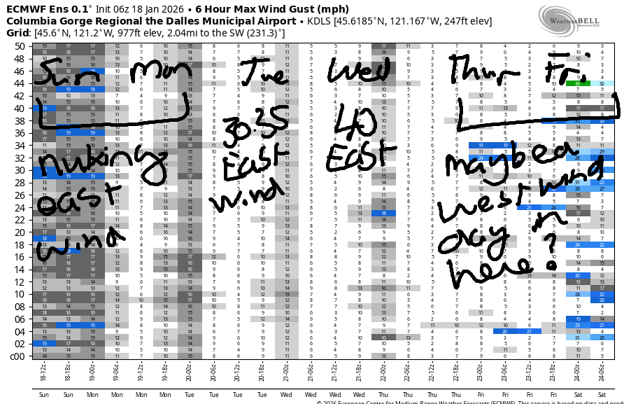
Hi friends! Strong to nuking easterlies continue for the next four days. The GFS deterministic is hinting at westerlies on Thursday, but that seems low-probability to me. While that seems unlikely, it does seem likely that the weather pattern we’ve been enjoying (?) will shift by the end of the upcoming week.
Today, however, brings another round of nuking easterlies. Pre-dawn pressures were 30.30/30.51/30.53 for a strong offshore gradient. Wind is not spilling over the Cascades – it’s dead calm at Meadows. Iwash (Rooster) started at 54mph, Stevenson at 29mph, and Viento at 23mph. The wind holds at Stevenson and Viento and drops to 40-50mph at Iwash this afternoon. River flow over the last 24 hours was 204-213kcfs, river temp is 42.8F, and high temp forecast is 41F with sunshine in the east wind zones.
RIVER FLOW FOR SITES BETWEEN AVERY (EAST OF THE DALLES) AND RUFUS: CLICK HERE FOR JOHN DAY DAM FLOW.
RIVER FLOW FOR SITES BETWEEN STEVENSON AND DOUG’S BEACH (WEST OF THE DALLES): CLICK HERE FOR THE DALLES DAM FLOW

LONGER-TERM gorge wind forecast
Monday looks like a nuker. Iwash starts with 60mph and only fades to 55mph. Stevenson starts with 35-40mph and fades to 30-35mph. High temp: 42F with, you got it, sunshine in the east wind zones. Tuesday looks lighter. Easterlies start with 20-25mph at Stevenson and Iwash, rises to 30-35mph at both locations midday, and fade to 25-30mph in the afternoon.
On Wednesday, stronger easterlies return – 40mph is likely at Iwash. Models are uncertain about the wind on Thursday. The 12k GFS deterministic insists we’ll see west wind, but I think it’s unlikely the desert cold pool will break down enough to allow that to happen so soon. We’ll watch it closely. Stay safe out there today. Dress warmly, have an emergency plan, and keep an eye on your buddies!
BARE BONES HOOD RIVER WEATHER FORECAST
Nothing today. Temps start in the mid 30s and rise to the low 40s. Light to moderate easterlies. No rainbows. Monday will be Nothing and then potentially at least partly sunny. Temps start in the low-mid 30s and rise to the low 40s. Light to moderate easterlies. No rainbows. Tuesday will be Nothing, but less of it, and then potentially at least partly sunny. Temps start in the low-mid 30s and rise to the low 40s. Light to moderate easterlies. No rainbows.
TEMIRA’S AWESOME TRAVEL ADVISORY SERVICE
HYPERLOCAL WEATHER FORECAST FOR THE COLUMBIA GORGE
THE DALLES, HOOD RIVER, WHITE SALMON, TROUT LAKE, STEVENSON, CASCADE LOCKS, PARKDALE, ODELL, HUSUM, BZ, MILL A, WILLARD, GOLDENDALE, RUFUS, ARLINGTON, boardman
Good morning, neighbors! Not much to report here this morning. Weather: on repeat. Nothing is slated to change until the latter part of next week, when there’s a slight chance something interesting (snow? Freezing rain?) could happen as we break out of this pattern. Signs of “interesting” weather are not clear yet, so let’s hold off on panic.
Glenwood this morning
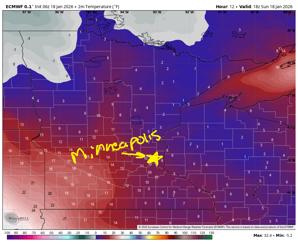
Looking around the Gorge this morning, we see Nothing. Temps generally range from 30-35F with some colder temps above the inversion. In my house, it’s 68F. In Glenwood, thermometers read 29F. Roads will have areas of frost in the Nothing zone and above it. So far this morning, there’s no sign of ¡CE on Gorge roads. All the bad “weather” is currently in Minnesota, where it’s snowing lightly, 3F degrees, and the forecast low for tonight is -6F. Brrrrrr!
Gorge weather forecast for the next several days
Yesterday’s forecast would have sufficed for today. We’ll have Nothing all day today with temps rising to the upper 30s or low 40s. East wind at Iwash (it’s NOT a rooster) Rock starts at 55mph and drops to 40-45mph. Stevenson sees 30mph all day. Brrr. Monday looks almost identical to Sunday with a better chance of the Nothing burning off and 5-10mph stronger east wind in those spots I mentioned.
Tuesday: Nothing near the Nch’i Wana and clear sky away from it to start the day. Afternoon: models seem to think the Nothing will burn off. I like this idea, and you probably do too. Temps will be in the mid to upper 20s away from the Nothing and 30-35F underneath it early. Afternoon: low 40s. Wind: 30-35mph in the usual east wind spots. Wednesday looks similar to Tuesday with the addition of stronger east wind and afternoon high clouds. Thursday: cloudy. Friday: finally, finally, SOMETHING might happen, but the details are unclear. Let’s leave it there for now. Safe travels. -TATAS
HEY! DON’T STOP READING! Is this community-focused forecast helpful to you? It sure is! It takes me a couple hours a day to write. Please join your friends and neighbors in contributing to keep it going. Venmo: @thegorgeismygym PayPal: twomirrors@gmail.com USPS: Temira / PO Box 841 / Hood River, Oregon 97031 You can test out the forecast subscription for a few days for free by signing up below. Easy! Do it!
JONES BEACH, SAUVIE ISLAND, & COAST FORECAST
ON WINTER VACATION UNLESS DESPERATELY NEEDED.
