

MT HOOD SNOW FORECAST

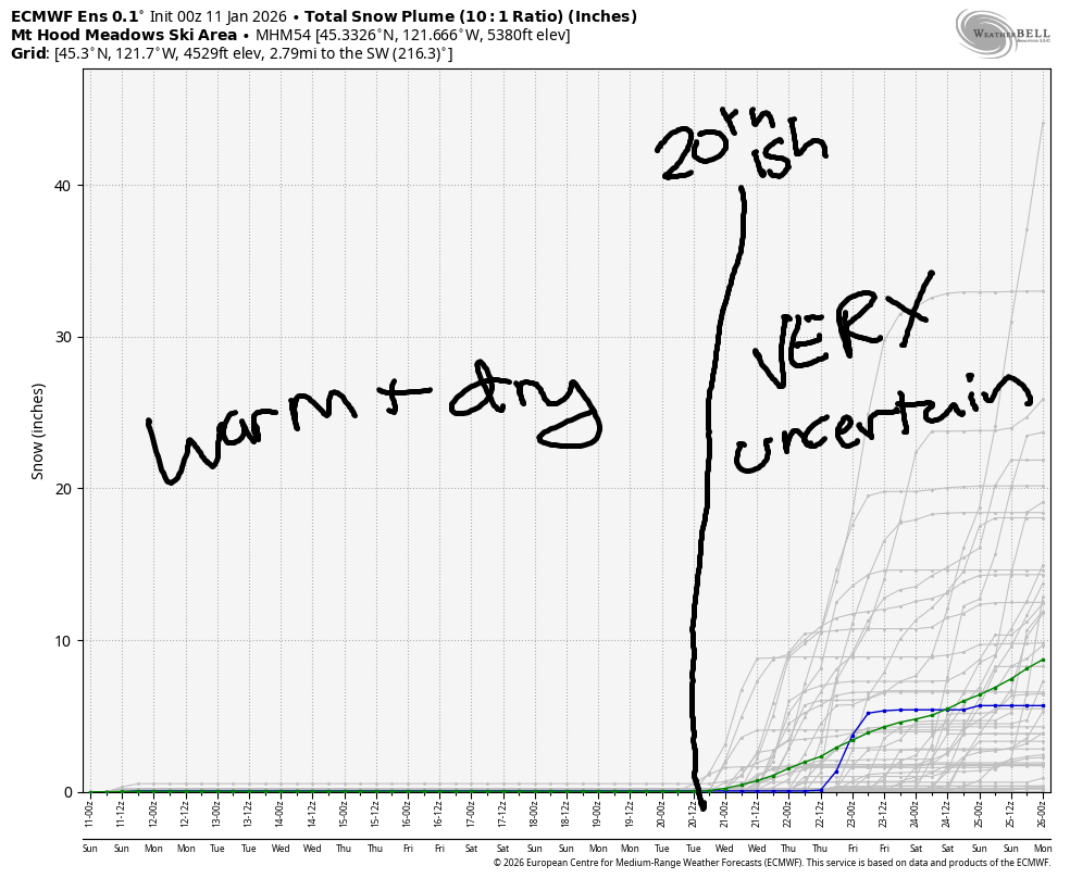
Hey skiers and snowboarders! Dry, warm weather is forecast for Mt Hood for the next week or so. Thankfully we picked up a few feet of snow last week to get us through the upcoming stretch of Juneuary. FYI, I’m taking tomorrow (Monday) off from forecasting as the forecast is static and easy to predict for now. And I’m tired! And I want to go skiing!
Short term Mt Hood snow forecast
Sunday brings clouds to Mt Hood as a weather system passes by to the north and west of the metro area. In the afternoon, the clouds could drop low enough to bring fog to the slopes. The free air freezing level (FAF) will be 9000′ in the morning, 8000′ in the afternoon, and 10,000′ overnight. Wind will be SW 20-30 in the morning and WSW 20-25 from afternoon on into the night.
Monday will be cloudy to start and clear in the afternoon. The FAF will be 10,000′ in the morning, 11,000′ in the afternoon, and 12,000′ overnight. Temps max out in the upper 40s at 5000′. Wind: WSW 20-25 in the morning, W 15 in the afternoon, and SW 5-10 overnight.
Extended Mt Hood Snow Forecast
Tuesday will be sunny and warm with temps at 5000′ exceeding 50F. FAF: over 10,000′. Wind: variable to 10mph. Sunshine is forecast on Wednesday, but NW wind will drive temps a little lower in the afternoon. The FAF remains at 10,000′ or higher. Wind: SW 10 in the morning and NW 20-30 in the afternoon with E 10 overnight. Temps max out in the mid to upper 40s. Warm, sunny weather is currently forecast for Thursday and Friday with easterly or northeasterly wind.
Models bring precipitation back sometime in the 20-23rd time frame, but it’s unclear what type of precip we’ll see. The GFS insists temps will be cold enough for snow. The ECMWF is less optimistic. Let’s make it through several days of this warm dry weather and see if those models start to coalesce around a shared solution. In the meantime… enjoy the warm spring skiing!
Was that helpful? I knew it was! Guess what? All of this crucial work – from your personal wind and snow reports to the invaluable TATAS updates – is made possible by my relentless efforts. Maintaining this labor of love isn’t easy. Each daily forecast takes hours. Website hosting, weather model access, and back-end admin work takes time and money. That’s where you come in.
YOUR CONTRIBUTION MAKES A DIFFERENCE
- SUPPORT ACCURATE, HYPER-LOCAL WEATHER FORECASTING
- ENABLE ACCESS FOR ALL, EVEN THOSE WITH LESS MEANS
- SUPPORT A COOL HUMAN WHO WORKS HARD SO YOU CAN PLAY
Take a moment to click one of the buttons below. Donate $19.99 or more (how much does this forecast enhance your life?) and get the email in your inbox. Whether it’s a renewing subscription (auto-renew) or a one-time donation, every contribution makes a real difference. Help me keep this labor of love alive, so we can all continue playing, commuting, and living in the Gorge with peace of mind and the best weather forecasts possible. Thank you!


Hood River, Oregon 97031


GORGE WIND FORECAST
If you’re still seeing yesterday’s and it’s after 9am, try opening this in an incognito window
SHORT-TERM gorge wind forecast
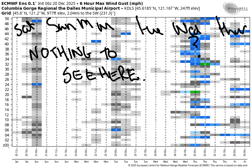
Hi friends! Not much happening Sunday through Tuesday, but models continue to hint at a decent Corridor west wind day on Wednesday. After that: probably back to easterlies. Let’s take a look, shall we?
Sunday started with pressures of 30.39/30.46/30.46 for light offshore flow. Mid-morning sees Stevenson rise to 20mph and Iwash (Rooster) Rock rise to 15-20mph. The wind fades into the afternoon. Stevenson finishes up with 10mph and Iwash ends the day with 15mph. River flow over the last 24 hours was 197-213kcfs, river temp is 43.0F, and high temp forecast is 49F with increasing clouds.
RIVER FLOW FOR SITES BETWEEN AVERY (EAST OF THE DALLES) AND RUFUS: CLICK HERE FOR JOHN DAY DAM FLOW.
RIVER FLOW FOR SITES BETWEEN STEVENSON AND DOUG’S BEACH (WEST OF THE DALLES): CLICK HERE FOR THE DALLES DAM FLOW

LONGER-TERM gorge wind forecast
Monday starts with easterlies at 10mph in the usual spots. Rooster ends light and variable. Stevenson switches to westerly, 10-13mph, in the afternoon. High temp: 53F and partly cloudy. Tuesday peaks mid- morning with 25mph at Stevenson and 25mph at Iwash Rock. The wind fades to 20mph at Stevenson and 15mph at Iwash Rock in the afternoon. High temp: 54F and sunny.
Models are hinting at an interesting mid-winter setup on Wednesday: very strong high pressure offshore may drive marine clouds into the metro area and allow desert heating to exceed temps on the west side. As of this morning, the GFS suggests 21-24mph in the Corridor on Wednesday. That would be awesome. My fingers are crossed. East wind returns on Thursday and sticks around for a while. That’s all I’ve got for you today. I’m taking tomorrow off, because there’s not much to talk about in any of the domains this week!
BARE BONES HOOD RIVER WEATHER FORECAST
Clouds today. Temps start in the mid 30s and rise to the upper 40s. Light easterlies. No rainbows. Monday will be cloudy. Temps start in the upper 30s and rise to the low 50s. Light and variable wind. No rainbows. Tuesday will be partly Nothing then sunny. Temps tart in the upper 30s and rise to the mid 50s. Light easterlies. No rainbows.
TEMIRA’S AWESOME TRAVEL ADVISORY SERVICE
HYPERLOCAL WEATHER FORECAST FOR THE COLUMBIA GORGE
THE DALLES, HOOD RIVER, WHITE SALMON, TROUT LAKE, STEVENSON, CASCADE LOCKS, PARKDALE, ODELL, HUSUM, BZ, MILL A, WILLARD, GOLDENDALE, RUFUS, ARLINGTON, boardman
Good morning, neighbors! Rather mild, low-impact “winter” weather is in the cards for the next week. At least the next week. Maybe longer. Guess what that means? I get to take a day off from forecasting on Monday and catch up on stuff (read: go skiing, then be too tired to catch up on stuff). Let’s take a look at what we’ve got coming up…
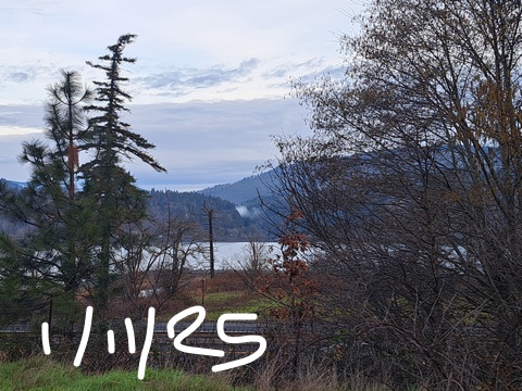
Glenwood this morning
We’ll start with Glenwood, where it’s 32 degrees this morning. Trout Lake matched that, but everyone else is warmer. You may find icy or frosty areas on the roads today thanks to radiational cooling, but nobody has seen ¡CE. If you have something you’d like to say about ¡CE, there are protests today: 1pm at 2nd and State in Hood River; 3-4pm at the I-84 overpass in Mosier and Hood River overpass at Exit 63. If you’d like to protest the weather, you can do that any time, but it’s unlikely to have any effect at all.
Today’s Gorge weather forecast
Today’s weather isn’t really worth wasting energy protesting: it’ll be increasingly cloudy (mid and high to the west, high clouds to the east). Temps climb to nearly 50 degrees all throughout the lowlands with the freezing level around 8000′ this afternoon. Wind maxes out at E 20mph near Stevenson and Iwash (p*nis) Rock before dropping to 10-15mph this afternoon. Elsewhere: light east wind.
Monday’s Gorge weather forecast
Overnight, we’ll hang on to clouds. This should keep us all above freezing… call it 38F to start Monday. Afternoon brings light/variable wind with temps pushing into the low 50s. Record high temp for Monday is 60F in Hood River. That is not within reach. Record snowfall: 9”. Also not within reach. Record low: -1F. Definitely not within reach. For the rest of Monday, we’ll have diminishing clouds and increasing amounts of filtered sun.
Tuesday’s Gorge weather forecast
Tuesday, thanks to clear sky, starts with a partial Nothing near the Nch’i Wana. By afternoon, we’ll all be basking in 55 degree sunshine as far east as The Dalles. Out in the desert, highs “only” make it to 50F. WARM! Wind will be light/variable early with easterlies at 20-25mph in the usual spots in the afternoon. Models suggest sunshine on Wednesday morning with partly cloudy sky west of Mosier in the afternoon. Highs climb to the mid 50s (west), low 50s (The Dalles), and upper 40s (The desert).
Extended Gorge weather forecast
Clear, dry weather is forecast Thursday and Friday and … sheesh… models keep us dry at least through the 20th of January and potentially for longer. Things get really ridiculous the middle of this week as a 99th percentile ridge of high pressure settles off the coast and sends temps soaring to nearly 60F in areas of the Valley of Willies (Willamette Valley) and the coast. Hopefully that melts all the ¡CE. Unfortunately, it’s also going to do some melting of the mountain snowpack, currently sitting at just 39% of normal. Alas… well, the good side of this forecast is that driving conditions will be friendly for the next 7-10 days. Safe travels. -TATAS
HEY! DON’T STOP READING! Is this community-focused forecast helpful to you? It sure is! It takes me a couple hours a day to write. Please join your friends and neighbors in contributing to keep it going. Venmo: @thegorgeismygym PayPal: twomirrors@gmail.com USPS: Temira / PO Box 841 / Hood River, Oregon 97031 You can test out the forecast subscription for a few days for free by signing up below. Easy! Do it!
JONES BEACH, SAUVIE ISLAND, & COAST FORECAST
ON WINTER VACATION UNLESS DESPERATELY NEEDED.
