

GORGE WIND FORECAST
If you’re still seeing yesterday’s and it’s after 9am, try opening this in an incognito window
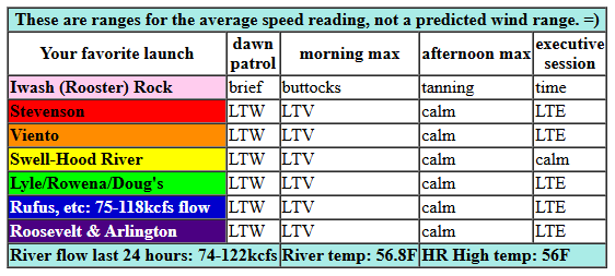
today’s gorge wind forecast
Hi friends! Sounds like some folks were able to catch the rainbow westerlies yesterday. Next chance for west wind is towards the end of the week. Between now and then: mostly easterlies and lots of rain. Hey, it’s November, of course that’s the forecast!
Looking at Sunday, we have light westerlies to start the day thanks to a light onshore gradient. The wind never gets strong enough to support your wind sport addiction; it turns calm midday and then switches to easterly. River flow over the last 24 hours was 74-122kcfs, river temp is 56.8F, and high temp forecast is 56F with sun in the morning and clouds later.
RIVER FLOW FOR SITES BETWEEN AVERY (EAST OF THE DALLES) AND RUFUS: CLICK HERE FOR JOHN DAY DAM FLOW.
RIVER FLOW FOR SITES BETWEEN STEVENSON AND DOUG’S BEACH (WEST OF THE DALLES): CLICK HERE FOR THE DALLES DAM FLOW

tomorrow’s gorge wind forecast
Monday looks very rainy, but there will be east wind. Monday starts with 30-35mph at Iwash and 20-25mph at Stevenson with 15-20mph at Viento. Afternoon wind falls to 15-20mpha t Stevenson and 20-25mph at Iwash (Rooster) Rock. Easterlies surge overnight. High temp: 50F and WET.
extended Gorge wind forecast
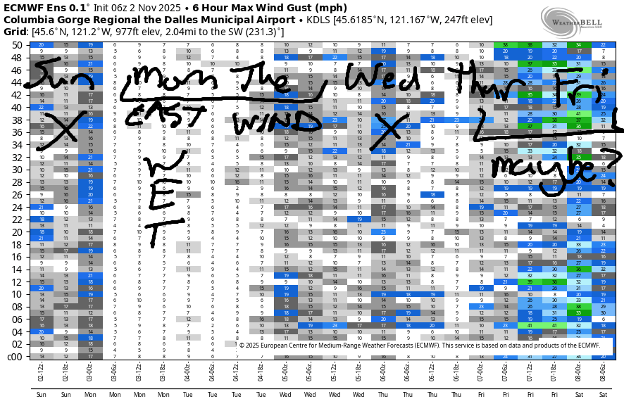
Tuesday starts with easterlies at 30mph at Stevenson and SW wind at Iwash (Rooster) Rock. Easterlies hold at 20-25mph most of the day near Stevenson and perhaps Viento. Iwash turns easterly at 20-25mph in the afternoon. Trying to forecast for the rest of the week is a losing proposition as the weather will be super active. Some of the ensemble members bring a low inland on Friday and give us the potential for westerlies. Fingers crossed! If not, hey, there are all sorts of alternative ways to get a workout… like the trainer bike in the living room… Hope to see you on the Nch’i Wana soon!
Was that helpful? I knew it was! Guess what? All of this crucial work – from your personal wind and snow reports to the invaluable TATAS updates – is made possible by my relentless efforts. Maintaining this labor of love isn’t easy. Each daily forecast takes hours. Website hosting, weather model access, and back-end admin work takes time and money. That’s where you come in.
YOUR CONTRIBUTION MAKES A DIFFERENCE
- SUPPORT ACCURATE, HYPER-LOCAL WEATHER FORECASTING
- ENABLE ACCESS FOR ALL, EVEN THOSE WITH LESS MEANS
- SUPPORT A COOL HUMAN WHO WORKS HARD SO YOU CAN PLAY
Take a moment to click one of the buttons below. Donate $19.99 or more (how much does this forecast enhance your life?) and get the email in your inbox. Whether it’s a renewing subscription (auto-renew) or a one-time donation, every contribution makes a real difference. Help me keep this labor of love alive, so we can all continue playing, commuting, and living in the Gorge with peace of mind and the best weather forecasts possible. Thank you!


Hood River, Oregon 97031


MT HOOD SNOW FORECAST

Hey skiers and snowboarders. A very active weather pattern is in place for the next week. Unfortunately, most of the moisture will come in as rain, and what snow does fall will be quickly followed by even more rain.
Here’s the general picture, subject to change as the timing/track of storm systems changes. Sunday will be sunny in the morning with high clouds later. The free air freezing level rises from 3000′ to 7500′ by Monday morning. Wind turns from W 25 in the morning to E 35 overnight. A period of wettish show (maybe 2-3”) during the day Monday gives way to an inch or more of rain overnight as the snow level rises from 4000′ to 7000. Wind: E 35 in the morning, SW 20-25 in the afternoon, and SW 30-50 Monday night.
Tuesday looks mostly dry during the day with about half an inch of rain overnight. Snow level: 6500′ early and 9000′ overnight. Wind: SW 30-35 early, S 15-25 in the afternoon, and SSW 30-55 overnight. It’s probably not worth making precision forecasts beyond that due to the highly active weather pattern. It does look like we’ll see rain Wednesday daytime and some snow Wednesday night, if we’re lucky. The pattern of bouncing snow levels and changing precip types continues through the end of the week. Don’t worry – we’ll get steady snow eventually!
BARE BONES HOOD RIVER WEATHER FORECAST
Clear sky this morning. Clouds late. Temps star tin the upper 40s and rise to the mid 50s. Light and variable wind. No rainbows. Monday will be rainy. Temps start in the upper 30s and rise to 50. Light easterlies. 8% chance of rainbows. Tuesday will be showery early and mostly cloudy later. Temps start in the upper 30s and rise to the mid 50s. Light easterlies. 11% chance of rainbows.
TEMIRA’S AWESOME TRAVEL ADVISORY SERVICE
HYPERLOCAL WEATHER FORECAST FOR THE COLUMBIA GORGE
THE DALLES, HOOD RIVER, WHITE SALMON, TROUT LAKE, STEVENSON, CASCADE LOCKS, PARKDALE, ODELL, HUSUM, BZ, MILL A, WILLARD, GOLDENDALE, RUFUS, ARLINGTON, boardman
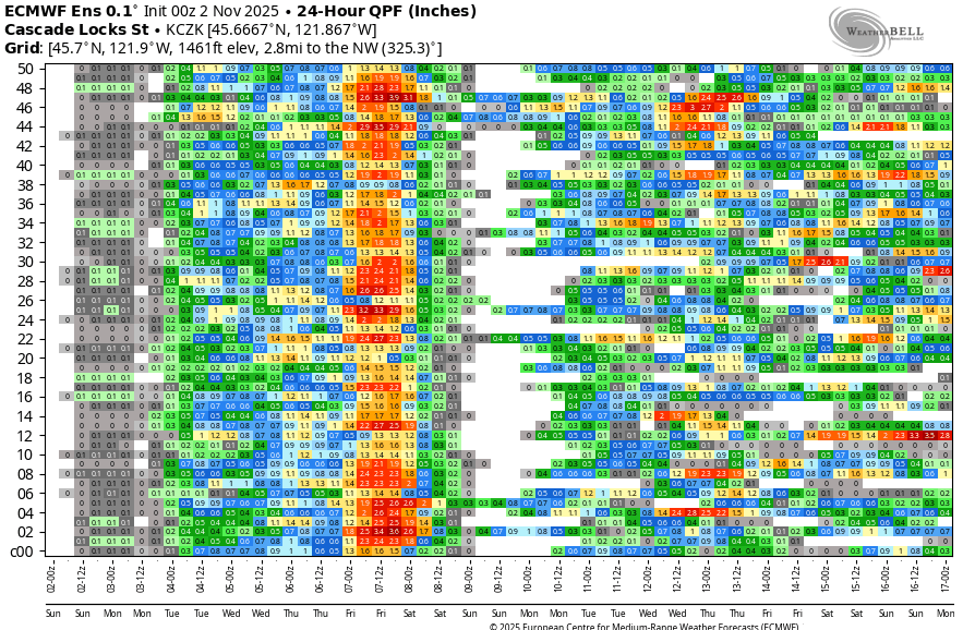
Good morning, neighbors! Damned fine morning out there after a fucking wet day yesterday. But guess what? We weren’t even close to record rain yesterday. That record belongs to 1994, when 2.26” of rain fell in Hood River. Whoa. While this week is going to be wet, records are unlikely to fall. Up in the mountains this week: mostly rain. Alas. Yep… what we have going on most of the week is simply Cold November Rain. Thankfully, nothing lasts forever… even cold November rain…
Glenwood this morning
Looking at Sunday, we see a 38 degree start in Glenwood, where folks are mending their galoshes in anticipation of a puddly-muddy week. The rest of us: enjoying the morning light and the morning sunshine. Temps rise to the mid 50s (west) or upper 50s (east) today with light/variable wind. Clouds arrives this afternoon and steal the sun, so get out there and enjoy it right now. Near Hood River? Today is the Fill Your Pantry event at the Rockford Grange. There are bonus dollars for folks on SNAP, so if you’re experiencing food insecurity, head on over. 12-4pm.
Overnight: cloudy. NO STARS FOR YOU!
Monday Gorge weather forecast
Monday: WET. Rain starts by 7am in Hood River, 10am in The Dalles, and the wetness makes it all the way to Idaho in the afternoon. Expect very heavy rain west of Hood River after 1pm and heavy rain all the way to Biggs and Goldendale (the place, not the dog breed) in the evening. It’s going to be a very unpleasant drive to/from the metro area on Monday afternoon. Skip it if you can. Up on the passes, there may be a brief period of heavy, wet snowfall mid to late afternoon, but rain replaces the snow and continues all night. High temps in the lowlands: 50F after a 40F start. Wind: easterlies at 30mph near Iwash (rooster-cock-pen*s) Rock and 20-25 near Cascade Locks during the day. Much stronger overnight, just in time to combine with heavy rain for a messy, messy drive.
Extended Gorge weather forecast
Rain tapers off Tuesday morning and leaves us dry from mid-morning on. West side: cloud. East side: sunny. Despite the varying cloud cover, the lowlands all max out in the mid 50s. Wind: easterly at 20-25mph near Stevenson all day becoming E 10mph+ east of Hood River in the afternoon as a low spins offshore, spins me right round like a record baby right round round round. Next rain: from the south Tuesday night into Wednesday. Coming from the south, this rain won’t result in rain shadowing; south Wasco and all y’all east of the Cascade Crest will get a soaking along with the west side. Wednesday: showers and rainbows. Thursday: less rainy, but not for long. Another wet system is forecast for Friday. And so it goes. November, baby, November. It’s a wet one. Lots of Cold November Rain. Safe travels. -TATAS
HEY! DON’T STOP READING! Is this community-focused forecast helpful to you? It sure is! It takes me a couple hours a day to write. Please join your friends and neighbors in contributing to keep it going. Venmo: @thegorgeismygym PayPal: twomirrors@gmail.com USPS: Temira / PO Box 841 / Hood River, Oregon 97031 You can test out the forecast subscription for a few days for free by signing up below. Easy! Do it!
JONES BEACH, SAUVIE ISLAND, & COAST FORECAST
ON WINTER VACATION UNLESS DESPERATELY NEEDED.
