

GORGE WIND FORECAST
today’s gorge wind forecast
Hi friends! It’s swap meet morning at Windance – 8am to noon, socializing welcome the entire period… except when the move Addikted is playing (9am, 10:30am, and noon). Sounds like a fun morning! We’ll also have (probably) just enough wind today to get you on the water. Gorge wind forecast for the next week: wind of some sort every day except Monday, which I’m taking off from forecasting. And while you’re out and about today, take a moment to contribute to the GoFundMe for Bingen Bart, the OG of Gorge wind forecasters and just a good human being. Bart lost everything in the Rowena fire, and we’re going to help him get back on his feet, better than ever before!
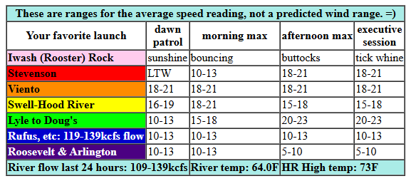
Let’s look at Sunday’s wind. Pressures starts at 30.12/30.06/30.03 for gradients of 0.06/0.03. Westerlies were hanging in the 16-19 range to start the morning between Viento and Swell with less than 10mph everywhere else. We’ll see a slow start, perfect for swapmeeting. Westerlies rise to 18-21 from Stevenson to Doug’s by early afternoon. Models suggest the Stevenson-Hood River zone will drop to 15-18 while Mosier-Avery rises to 20-23 mid-afternoon. East of there: less than 10mph all day. River flow over the last 24 hours was 109-139kcfs (119-139kcfs at Rufus), river temp is 64.0F, and high temp forecast is 73F.
RIVER FLOW FOR SITES BETWEEN AVERY (EAST OF THE DALLES) AND RUFUS: CLICK HERE FOR JOHN DAY DAM FLOW.
RIVER FLOW FOR SITES BETWEEN STEVENSON AND DOUG’S BEACH (WEST OF THE DALLES): CLICK HERE FOR THE DALLES DAM FLOW

tomorrow’s gorge wind forecast
Not much happens wind-wise on Monday. Warm temps are forecast from the west side to the east side. Calm wind starts the day. Westerlies rise to 11-14 in the afternoon from Stevenson to Mosier and then spread east to the Lyle-Doug’s zone. East of there: basically calm all day. Seems like a good day for me to take off – it’s been about six weeks since I took a day off! High temp: 82F.
extended Gorge wind forecast
On Tuesday, temp gradients amplify across the Cascades, and this sets us up for a windier day. With the metro area forecast to be clear and warm, a midday lull is likely between Swell and Hood River. The day starts with 10-13 from Viento to Swell and quickly rises to 17-20 from Stevenson to Mosier. Swell-Hood River then drops to gusty 16-19 while other locations between Stevenson and Avery rise to 20-23. As heat intensifies in the desert late afternoon, you’ll find 22-25 from Mosier to Rufus. There’s some hint that Swell-Hood River will recover to gusty 21-24 for the Executive Session (after 5pm). High temp: 84F for Hood River.
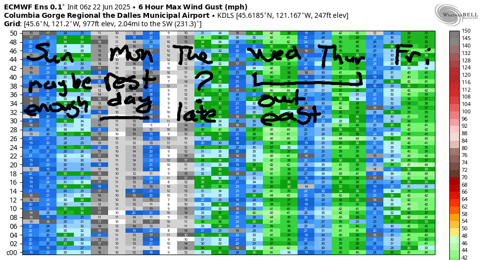
A cool trough moving inland (probably) for the Wednesday-Friday period gives us a shot at stronger wind. Agreement is lacking on the strength of this feature, but models do suggest we’ll see westerlies in the 26-29 range each day, focused east of Hood River. Uncertainty really climbs starting next weekend. At this point, Saturday and Monday (Monday is part of the weekend because it’s part of Canada Day weekend) look stronger than Sunday, but again, there’s lots of range in the models. There are hints of westerlies each day of the extended starting Monday, but again, lots of range in the possible outcomes. Have a great day today. I’ll see you on the Nch’i Wana!
Was that helpful? I knew it was! Guess what? All of this crucial work – from your personal wind and snow reports to the invaluable TATAS updates – is made possible by my relentless efforts. Maintaining this labor of love isn’t easy. Each daily forecast takes hours. Website hosting, weather model access, and back-end admin work takes time and money. That’s where you come in.
YOUR CONTRIBUTION MAKES A DIFFERENCE
- SUPPORT ACCURATE, HYPER-LOCAL WEATHER FORECASTING
- ENABLE ACCESS FOR ALL, EVEN THOSE WITH LESS MEANS
- SUPPORT A COOL HUMAN WHO WORKS HARD SO YOU CAN PLAY
Take a moment to click one of the buttons below. Donate $19.99 or more (how much does this forecast enhance your life?) and get the email in your inbox. Whether it’s a renewing subscription (auto-renew) or a one-time donation, every contribution makes a real difference. Help me keep this labor of love alive, so we can all continue playing, commuting, and living in the Gorge with peace of mind and the best weather forecasts possible. Thank you!


Hood River, Oregon 97031


JONES BEACH, SAUVIE ISLAND, & COAST FORECAST
Wind northerly unless otherwise indicated. For coast, it’s North/Central/South with the “central” at approximately Florence. Swell forecast from NWS for central coast. Jones: westerly unless otherwise stated. Sauvie Island: northerly unless otherwise stated. Sunday: W5-10/N5-10/N25-30, W swell 4′ at 12 seconds. Monday: NNW15/N15-20/N25, W 4′ @ 11. Tuesday: NW10/NW10/N20-25, W 4′ @ 12. Jones Sunday: 14-17. Monday: 14-17. Tuesday: 21-24. Sauvie Island Sunday: 11-14. Monday: 11-14. Tuesday: 15-18.
BARE BONES HOOD RIVER WEATHER FORECAST
Clouds this morning turns partly cloudy this afternoon. Temps start in the mid 50s and rise to the low 70s. Moderate westerlies. No rainbows. Monday will be mostly clear then high cloudy. Temps start in the low 50s and rise to the low 80s. Calm wind early. Light westerlies later. No rainbows. Tuesday will be mostly clear then high overcast. Temps start in the mid 50s and rise to the mid 80s. Light west wind early. Moderate later. No rainbows.
TEMIRA’S AWESOME TRAVEL ADVISORY SERVICE
HYPERLOCAL WEATHER FORECAST FOR THE COLUMBIA GORGE
THE DALLES, HOOD RIVER, WHITE SALMON, TROUT LAKE, STEVENSON, CASCADE LOCKS, PARKDALE, ODELL, HUSUM, BZ, MILL A, WILLARD, GOLDENDALE, RUFUS, ARLINGTON, boardman

Good morning, neighbors! With the exception of slight chance of showers for a few of us today and a wee chance of a tiny bit of drizzle on Thursday, we’re done with rain for a bit. Ma Nature, if you can hold off on rain until cherry season is done, that would be great. No need to make folks panic. We’ll take an inch of rain the day cherry harvest is done, please. Setting aside wishful thinking, we have a rather uneventful week on tap, weather-wise. Relatively mild weather sticks around through Friday or Saturday. That’s followed by a brief warm-up for Canada Day weekend, and that’s followed by uncertainty about everything other than Canadian Wind Johnnies visiting the Gorge (hopefully with Cheezies and Coffee Crisp).
glenwood and today’s gorge weather forecast
Saying hello to our friends in Glenwood this morning, we see… everyone in their rocking chairs looking at the pretty clouds while sipping coffee doctored up with fresh, raw heavy cream. Some folks may have added moonshine to their morning cup of joe, but we won’t talk about that here in public. The rest of us started Sunday in the 47-58 degree range. We’ll top out in the low 70s (west), upper 70s (The Dalles) and 80ish (watermelon growing areas near Hermiston, where the Carolina Cross melons are simply annoyed at the lack of heat). The west side starts cloudy and ends partly cloudy. East side: mostly clear adding a a few mid-level clouds. Models do hint at the possibility of a few instability-driven showers between Appleton and Goldendale this afternoon, but that’s far from guaranteed.
Monday’s gorge weather forecast
Monday looks like a great day to spray. I’ll be spraying for powdery mildew on my 2085 Toboyek and 2453 Sherwood pumpkin plants. This means I’m going to take Monday morning off from forecasting. We start with calm wind, for once. Afternoon westerlies rise to 10mph from Stevenson to Mosier. East of there: calm. Hills: calm in the morning and NW 5-10 in the afternoon. Mostly clear sky starts the day. High clouds drift in from the west in the afternoon and work their way east to the Cascade Crest, where they stop and enjoy the views, marvel at the fresh June snow, and make snow angels. By then it’ll be dark, and those clouds will go to bed and travel no farther east. High temps on Monday: 82 (west), 86 (The Dalles), and 88 (watermelon zones, where the watermelons will be happy).
tuesday’s gorge weather forecast
A weak system moving in early Tuesday doesn’t do much more than nudge the wind upwards. Mostly clear sky early turns high overcast in the afternoon. Temps rise to the mid 80s (west), upper 80s (The Dalles), and mid 90s (watermelon zones, where the watermelons are displaying shit-eating grins and growing FAST). West wind starts at 10-13mph between Viento and Bingen. It rises to 20-25mph in the afternoon between Stevenson and Rufus with less wind to the east of Rufus.
extended gorge weather forecast
Wednesday, Thursday, and Friday look windy (25-30mph) and cooler (under 80 degrees). About 50% of the Euro ensemble has a trace of rain as far east as Cascade Locks on Thursday. The GFS is more aggressive with its forecast and holds out the possibility of an assertive drizzle. That outcome seems unlikely at this point. Beyond that, there’s a lot of uncertainty in the forecast as ensemble members argue over troughing and ridging (a rather innocuous thing to argue about compared to other options). So let’s leave it there for now. Safe travels. -TATAS
HEY! DON’T STOP READING! Is this community-focused forecast helpful to you? It sure is! It takes me a couple hours a day to write. Please join your friends and neighbors in contributing to keep it going. Venmo: @thegorgeismygym PayPal: twomirrors@gmail.com USPS: Temira / PO Box 841 / Hood River, Oregon 97031 You can test out the forecast subscription for a few days for free by signing up below. Easy! Do it!
