

GORGE WIND FORECAST
If you’re still seeing yesterday’s and it’s after 9am, try opening this in an incognito window
today’s gorge wind forecast
Hi friends! I was very glad I threw that “+” in the forecast yesterday – the marine clouds over-performed, kept the low levels stable, and fired up a very windy afternoon at the Hatchery. We’ll have another round of solid west wind today. After today, a low pressure system settles in over the Pacific Northwest and (mostly) knocks down the wind speed for at least several days.
Before I dive in to today’s forecast… if you were at the Hatch yesterday and are missing an impact vest, sunshirt, and a rando neoprene garment, shoot me an email. I have these items that fell off your car at the entrance to the Hatch. On to the forecast… pressures at 7am were 30.06/29.97/29.93 for gradient of 0.09/0.04. Marine clouds were stacked up just west of the Hatchery with a few clouds past Hood River. It appears clouds will linger in the metro area for much of the day, which generally means more wind than models suggest.
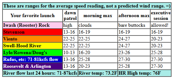
The Viento-Hatch zone started with 20-23mph this morning. Pretty much everywhere else (Stevenson, Rowena, Rufus, Arlington) was in the 13-16mph range. Models think the desert will be slow to heat today which means strongest wind will be in the afternoon. Expect 22-25mph this morning from Viento to the Hatch with Hood River and Mosier joining late morning. The GFS thinks the Stevenson-Hood River zone will drop to 17-20mph this afternoon, but that seems suspect given the metro-area clouds. I’ll sgo with 24-27mph. And if that doesn’t work out, head east. Between Mosier and Rufus this afternoon, westerlies rise to 25-28mph. Rufus rises to 27-30mph mid afternoon (remember, this is equivalent to 20-24mph or so on the Hatch sensor), and Arlington joins at 25-28mph (19-22mph Hatch sensor equivalent). River flow over the last 24 hours was 71-87kcfs (you were not imagining that yesterday was different!), river temp is 73.2F (potentially lethal to spawning salmon), and high temp forecast is 76F for Hood River and 84F for Rufus.
RIVER FLOW FOR SITES BETWEEN AVERY (EAST OF THE DALLES) AND RUFUS: CLICK HERE FOR JOHN DAY DAM FLOW.
RIVER FLOW FOR SITES BETWEEN STEVENSON AND DOUG’S BEACH (WEST OF THE DALLES): CLICK HERE FOR THE DALLES DAM FLOW

tomorrow’s gorge wind forecast
On Monday, a low pressure system settles in. This brings rain to the Gorge after 11am or so and really does a number on the wind. The day starts with 17-20mph from Viento to the Hatch with 11-14mph at Stevenson and east of the Hatch to Arlington. As a disturbance moves in early afternoon, we could see a brief period of strong wind (25-28mph) first at the Hatch, then from Lyle to Arlington. You’ll probably need to already be located at an eastern Gorge spot to take advantage of this. And… it’s low probability and also potentially linked to instability, so… Proceed at your own risk! High temp: 73F in Hood River and 81F at Rufus.
extended Gorge wind forecast
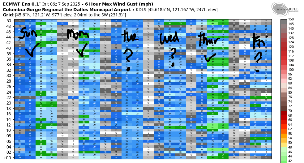
Another rainy, cool day is on tap Tuesday. We start with 10mph or less west of The Dalles and 14-17mph from The Dalles to Boardman. Between Lyle and Rufus, the wind rises to 18-21mph in the afternoon. High temp: 69F for Hood River and 75F for Rufus. Model uncertainty increases for the latter half of next week. Ensembles have Thursday as the strongest day of the bunch. Not a nuker, but maybe mid to upper 20s out east if we’re lucky? Let’s leave it there for now. Have a great day on the Nch’i Wana!
Was that helpful? I knew it was! Guess what? All of this crucial work – from your personal wind and snow reports to the invaluable TATAS updates – is made possible by my relentless efforts. Maintaining this labor of love isn’t easy. Each daily forecast takes hours. Website hosting, weather model access, and back-end admin work takes time and money. That’s where you come in.
YOUR CONTRIBUTION MAKES A DIFFERENCE
- SUPPORT ACCURATE, HYPER-LOCAL WEATHER FORECASTING
- ENABLE ACCESS FOR ALL, EVEN THOSE WITH LESS MEANS
- SUPPORT A COOL HUMAN WHO WORKS HARD SO YOU CAN PLAY
Take a moment to click one of the buttons below. Donate $19.99 or more (how much does this forecast enhance your life?) and get the email in your inbox. Whether it’s a renewing subscription (auto-renew) or a one-time donation, every contribution makes a real difference. Help me keep this labor of love alive, so we can all continue playing, commuting, and living in the Gorge with peace of mind and the best weather forecasts possible. Thank you!


Hood River, Oregon 97031


JONES BEACH, SAUVIE ISLAND, & COAST FORECAST
Wind northerly unless otherwise indicated. For coast, it’s North/Central/South with the “central” at approximately Florence. Swell forecast from NWS for central coast. Jones: westerly unless otherwise stated. Sauvie Island: northerly unless otherwise stated. Coast Sunday: W5-10/LTW/LTV, W swell 2′ at 11 seconds and SW 2′ at 14. Monday: LTW/LTW/S5-10, SW 2′ @ 13. Tuesday: LTV/LTV/N10-15, W 2′ @ 8 and SW 2′ @ 112. Jones Sunday: 10-13. Monday: LTW. Tuesday: LTW. Sauvie Island Sunday: 8-11. Monday: LTN. Tuesday: LTW.
BARE BONES HOOD RIVER WEATHER FORECAST
Partly cloudy sky this morning. Clear later. Temps start in the mid 60s and rise to the mid 70s. Moderately strong westerlies. No rainbows. Monday will be cloudy with rain possible after 11am. Temps start in the mid 50s and rise to the low 70s. Moderate westerlies. 62% chance of rainbows. Tuesday will be cloudy and drizzly then clear. Temps start in the upper 50s and rise to the upper 60s. Light westerlies. 89% chance of rainbows.
TEMIRA’S AWESOME TRAVEL ADVISORY SERVICE – SUNDAY
HYPERLOCAL WEATHER FORECAST FOR THE COLUMBIA GORGE
THE DALLES, HOOD RIVER, WHITE SALMON, TROUT LAKE, STEVENSON, CASCADE LOCKS, PARKDALE, ODELL, HUSUM, BZ, MILL A, WILLARD, GOLDENDALE, RUFUS, ARLINGTON, boardman
Good morning, neighbors! Looks like we’ve reached the end of the heat, at least for the next couple of weeks. We might even see some rain of the not-thunderstorm type to start the week. Morning temps will finally cool off some too, thankfully, making for some blissful nights of sleep.
Glenwood this morning
Looking at Glenwood this morning, nobody’s looking at the temp. They’re all hanging out Seahawks flags in support of the local team’s game today. If you were wondering, the temp in Glenwood this morning was a refreshing 53 degrees. That’s not cold enough for me to wear my fleece Seahawks onesie, but it is cool enough for a Seahawks hoodie.
The rest of us started off with yet another warm morning: 65 degrees at HoodRiverWeather.info‘s house and 59 degrees at HOXO, just two degrees shy of a record high-low. Temps rise to the mid 70s (west), mid 80s (The Dalles) and upper 80s (desert) today. West wind picks up to 20-25mph from Viento to Mosier this morning with 25-30mph from Stevenson to Rufus this afternoon.
Fun stuff is planned Monday! No, not war on Chicago. That’s not fun. That’s super fucked up. That is something you should be very, very, very concerned about. First they came for LA and Chicago. Next they came for your city or town. Do not be lulled into complacency because it’s not your home. Yet. And also do not panic. Stay steady, stay strong, and connect with your community.
Monday’s Gorge weather forecast
A low sets up over the PNW on Monday and taps into lots of moisture. An impulse moves in from the south late morning and squeezes the rain out of the air. Expect rain all the way east to Boardman on Monday. That includes south Wasco and Sherman counties, for once. Least rainy areas: the zone between Mosier and Celilo Village. Rain will be heavy at times west of Cascade Locks and also out near Boardman. How much rain? I wish I could say – the GFS and Euro disagree, and there’s quite a bit of range in the predictions within the ensembles. Let’s hope for “lots”. Monday wind starts at 15-20mph out of the west near Hood River and 10-15mph east of Hood River. Afternoon: 15-20mph from Stevenson to Mosier with 25-30mph from Lyle to Rufus. In the evening, the wind drops to 15-20mph. Temps start in the mid 50s under cloudy sky and finish in the 73F (west) to 84F (desert) range.
Tuesday’s Gorge weather forecast
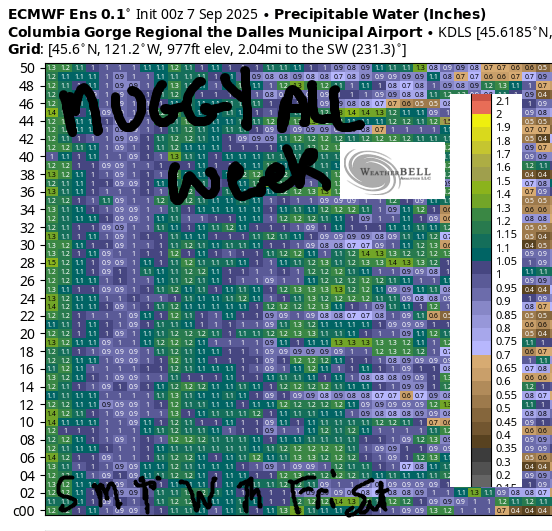
Another round of rain is forecast Tuesday morning. Combine that with an upper 50s start under cloudy sky for a cozy coffee morning. Afternoon brings muggy, partly cloudy weather with westerlies at 15-20mph. (FYI, it’ll be muggy every day between now and the end of the week, most likely) Mostly dry weather is forecast for the Wednesday0Friday period. Temps remain under 80 degrees on the west side and no hotter than the low 80s for The Dalles and the desert. All-in-all, it’s looking pretty darn pleasant! Looking at next weekend, well, you’ll be looking and I won’t. I’ll be at Cloud Mountain again helping out with a retreat. My favorite place in the world! Safe travels. -TATAS
HEY! DON’T STOP READING! Is this community-focused forecast helpful to you? It sure is! It takes me a couple hours a day to write. Please join your friends and neighbors in contributing to keep it going. Venmo: @thegorgeismygym PayPal: twomirrors@gmail.com USPS: Temira / PO Box 841 / Hood River, Oregon 97031 You can test out the forecast subscription for a few days for free by signing up below. Easy! Do it!
MT HOOD SNOW FORECAST

CURRENTLY ON VACATION. WILL RETURN SOMETIME BEFORE THE START OF SKI SEASON AT MEADOWS, TIMBERLINE AND SKIBOWL. SAME GOES FOR THE NORDIC SKIING SEASON AT MEADOWS AND TEACUP!
