

GORGE WIND FORECAST
today’s gorge wind forecast
Hi friends! West wind keeps on truckin’ today and the rest of the week. Despite moving pieces resulting in gustier, somewhat less reliable wind, there will be plenty of wind. Strongest days are likely to be Monday and Wednesday, if you trust the ECMWF ensembles.
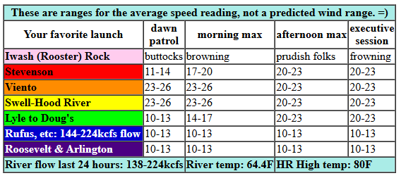
Looking at this morning (it’s Sunday), TJ’s Dawn Patrol (he’s at the Hatch) is looking good. Pressures were 30.19/20.08/30.04 for gradients of 0.11 (PDX-DLS) and 0.04 (DLS-PSC). These gradients suggest a corridor / near east day. Portland is only partly cloudy, and is going to clear fast. Result: a drop in the wind near the Hatch. So, for strongest results, get it early. The day starts with 23-26 from Viento to Swell, 19-23 near Hood River, and 10-13 at Stevenson and everywhere east of Mosier. By late morning or early afternoon, the wind drops to 20-23mph and fills in from Stevenson to Mosier. Between Lyle and Rowena, you’ll find 17-20mph early afternoon. If you see planes scooping water in the area, get out – fire fighting efforts take precedence over river play time. From mid-afternoon on, we should see 20-23 from Stevenson to Doug’s with 14-17 at Avery and less than 15mph east of Avery. River flow over the last 24 hours was 138-224kcfs (144-224kcfs at Rufus), river temp is 64.4F, and high temp forecast is 80F for Hood River and 84F for Arlington.

tomorrow’s gorge wind forecast
Monday sees a stronger thermal gradient as a weak front offshore keeps the west side cool(er). TJ’s Dawn Patrol looks like 26-29 from Viento to Mosier, 20-23 from Lyle to Rufus, and 14-17 east of Rufus to Arlington. Afternoon westerlies pick up to 29-33 from Lyle to Arlington with 27-30 at Threemile. Models suggest Stevenson-Swell will hold at 26-29 until early afternoon before turning gusty and lighter between Swell and Hood River. If we get really lucky, if clouds associated with this system linger in the metro area, Hatch-area wind will also hold. High temp: 76F for Hood River and 83F for Arlington.
extended Gorge wind forecast
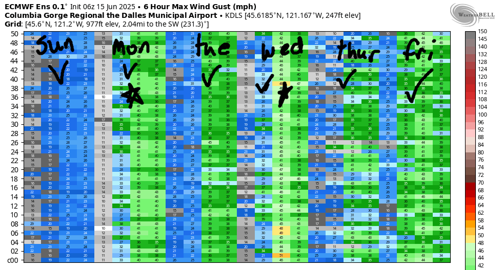
Tuesday sees lighter wind as we lose the NE Pacific High. Morning westerlies will be 18-21 from Viento to Mosier with 11-14 east of Mosier to Arlington. After a 2-3 hour period of 20-23 from Viento to Mosier, the strongest wind shifts east: 25-28 from Mosier to Boardman with gusty 19-22 between Stevenson and Hood River. High temp: 79F for Hood River and 82F for Arlington. The ECMWF ensembles and the GFS deterministic disagree on Wednesday’s outcome. Given that a weak front is likely to push clouds deep into the Gorge, the focus should be out east. 30ish mph seems like a reasonable guess at this time. Westerlies at 25mph or better continues through Saturday. After that, lots of uncertainty enters the picture. So, let’s leave it here for now. Have a great day on the river!
Was that helpful? I knew it was! Guess what? All of this crucial work – from your personal wind and snow reports to the invaluable TATAS updates – is made possible by my relentless efforts. Maintaining this labor of love isn’t easy. Each daily forecast takes hours. Website hosting, weather model access, and back-end admin work takes time and money. That’s where you come in.
YOUR CONTRIBUTION MAKES A DIFFERENCE
- SUPPORT ACCURATE, HYPER-LOCAL WEATHER FORECASTING
- ENABLE ACCESS FOR ALL, EVEN THOSE WITH LESS MEANS
- SUPPORT A COOL HUMAN WHO WORKS HARD SO YOU CAN PLAY
Take a moment to click one of the buttons below. Donate $19.99 or more (how much does this forecast enhance your life?) and get the email in your inbox. Whether it’s a renewing subscription (auto-renew) or a one-time donation, every contribution makes a real difference. Help me keep this labor of love alive, so we can all continue playing, commuting, and living in the Gorge with peace of mind and the best weather forecasts possible. Thank you!


Hood River, Oregon 97031


JONES BEACH, SAUVIE ISLAND, & COAST FORECAST
Wind northerly unless otherwise indicated. For coast, it’s North/Central/South with the “central” at approximately Florence. Swell forecast from NWS for central coast. Jones: westerly unless otherwise stated. Sauvie Island: northerly unless otherwise stated. Sunday: 20/20/25-30, N 5′ at 6 seconds. Monday: NW10/NW10/N20, NW 4′ @ 10 and S 2′ @ 17. Tuesday: LTW/LTW/N15, W 4′ @ 10. Jones Sunday: 17-20. Monday: 22-25. Tuesday: 13-16. Sauvie Island Sunday: 12-15. Monday: 16-19 > 5pm. Tuesday: 10-13.
BARE BONES HOOD RIVER WEATHER FORECAST
Clear sky all day. Temps start in the low 50s and rise to 80 or so. Moderately strong westerlies. No rainbows. Monday will be partly high cloudy then clear. Temps start in the low 50s and rise to the mid 70s. Strong westerlies. No rainbows. Tuesday will be clear. Temps start near 50 and rise to the upper 70s. Moderate westerlies. No rainbows.
TEMIRA’S AWESOME TRAVEL ADVISORY SERVICE
HYPERLOCAL WEATHER FORECAST FOR THE COLUMBIA GORGE
THE DALLES, HOOD RIVER, WHITE SALMON, TROUT LAKE, STEVENSON, CASCADE LOCKS, PARKDALE, ODELL, HUSUM, BZ, MILL A, WILLARD, GOLDENDALE, RUFUS, ARLINGTON, boardman
Good morning, neighbors! Rather pleasant weather with near-normal temps are forecast for the next 7-14 days. What a wonderful surprise this is given the heat of the last several summers! We might even see a little rain next weekend, which is great for all of us except cherry farmers. We’ll dive into the deets of this possibility a bit further down into the forecast.
Glenwood this morning
To start, let’s check in with Glenwood. It was 38 degrees there when I checked earlier. Everyone’s bundled up in down comforters while they’re sipping coffee while sitting in the porch rocker this morning. “Everyone” is the name of someone in Glenwood. I’m sure not everyone is sitting in a porch rocker sipping coffee. Some of the folks there are sipping coffee in the kitchen nook, some are sipping coffee in a hammock, and some are sipping coffee instead of reading the newspaper while they sit on the toilet pretending to poop but really just grabbing several minutes of peace and quiet.
today’s gorge weather forecast (it’s Sunday)
Temps today climb to 80 degrees (west) and 85 degrees (east) under mostly clear sky. Areas east of the Arlington Triangle pick up some high clouds this evening, and that puts them at risk of a pretty sunset. Pretty sunsets are risky, because they force you to be in the moment and bring you face-to-face with everything else going on in your internal world. But that’s actually a good thing, so maybe sunsets aren’t risky after all? Anyway, other weather today includes west wind at 20-25mph between Stevenson and Rowena with 15-20mph east to Celilo Village and less than 15mph east of there.
Monday’s gorge weather forecast
A somewhat cooler day on Monday brings us a much windier day. After a 50 degrees start, temps rise to the mid 70s (west) and low 80s (east). Westerlies pick up to 25-30mph west of Lyle and 30-35mph from Lyle to the Arlington Triangle with 25-30 east of there to Boardman, where as usual, the bored men will be heading to work on a Monday morning to stave off boredom.
extended gorge weather forecast
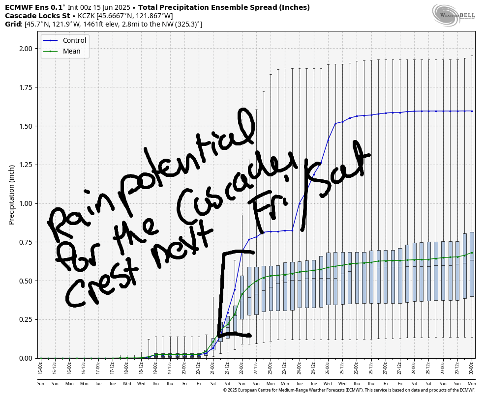
Tuesday, Wednesday, and Thursday look sunny and 75-80 degrees with 20-25mph west wind. Because it’s the Gorge, and that’s what the Gorge does. Starting Friday, an offshore low sends precipitation chances this way. As of this morning, The Dalles is forecast to receive just a trace. The Cascade Crest and areas west of Wyeth are looking at 0.25” to 0.6” total rain. All the cherries west of The Dalles fall into a questionable zone. As of this morning, models suggest up to 0.1” for the west side of Hood River and a trace to 0.05” for the east side of the valley, but those numbers could change. We’ll keep watching it this week. High temps Friday and Saturday are forecast to be 65 degrees or less. Helpful, for sure. Models also forecast moderately strong to strong west wind, which would help evaporate/dissipate any rain that does fall. So, as of right now, we’re not looking at a cherry disaster scenario, but we’ll definitely keep watching it. Happy farming. Safe travels. -TATAS
HEY! DON’T STOP READING! Is this community-focused forecast helpful to you? It sure is! It takes me a couple hours a day to write. Please join your friends and neighbors in contributing to keep it going. Venmo: @thegorgeismygym PayPal: twomirrors@gmail.com USPS: Temira / PO Box 841 / Hood River, Oregon 97031 You can test out the forecast subscription for a few days for free by signing up below. Easy! Do it!
