

GORGE WIND FORECAST
today’s gorge wind forecast
Hi friends! It’s Sunday morning, and it’s already windy out there. Not only is it windy, but we already have clouds indicating instability. This will likely affect wind quality and consistency today, but it should still be windy. Before you hop on the river, hop on down to the CGW2 swap meet at Lot 1 in Hood River. Looking beyond today: westerlies linger on Monday. Ridging shuts the wind down on Tuesday and gives us easterlies Wednesday morning. Depending on the timing and location of an incoming cold front, we could see an abrupt switch to west wind Wednesday evening. That’s followed by a strong west wind day on Thursday as offshore high pressure takes hold. Beyond that: uncertainty!
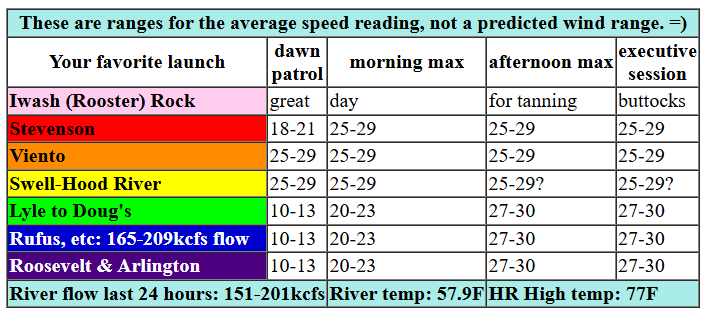
Sunday’s 6am gradients were 30.04/29.91/29.90 for an impressive 0.13 (pdx-dls) driving corridor westerlies in the mid 20s for Dawn Patrol. Westerlies hold for a few hours this morning at 25-29 from Viento to Hood River ( I see HUGE whitecaps from my window right now). Stevenson builds from the upper teens to the mid 20s. While areas to the east of Mosier are starting with 10-13ish, they’ll rise. By this afternoon, we’ll have 27-30 from Lyle to Rufus with 20-23 at Arlington.
Models hold the Stevenson to Mosier stretch at 25-28, but it’s possible Swell-Hatch could drop due to the influence of an incoming front and increasing instability. Get it earlier rather than later if that’s an option Speaking of instability, models give us strong wind in the desert this afternoon, but they also give us instability. So… it’s hard to say if the wind will fall apart on us. Again: earlier is better than later. River flow over the last 24 hours was 151-209 kcfs (165-209kcfs at Rufus). River temp is 57.9F, and high temp forecast is 77F for Hood River and 84F for Arlington.

tomorrow’s gorge wind forecast
Monday sees that cold front move through the region. Daybreak brings drizzle west of Mosier with westerlies at just 5-10mph west of The Dalles. Between Philippi Canyon (or perhaps Maryhill) and Arlington, early wind will be 14-17mph. By midday, as the front moves through, westerlies will be building. Wait until afternoon, and you’ll find 18-21 from Stevenson to Mosier with 24-27 from Lyle to Boardman. High temp: 70F for Hood River with drizzle in the morning and a few high clouds in the afternoon. Arlington: 72F and mostly sunny.
extended Gorge wind forecast

High pressure builds inland on Tuesday. We could see W 10-13 early in the morning, but models shut the wind off by mid-morning. Easterlies then pick up to 10mph near Stevenson in the afternoon. We call this “rest day”. High temp: 81F for Hood River and 79F for Arlington. High pressure sticks around on Wednesday morning and gives us easterlies at 25mph near Iwash (Rooster) Rock, Stevenson, and potentially Viento. If an approaching cold front arrives early enough (90% of the time in this setup it’s delayed), we could see moderate to strong westerlies for the executive session. High pressure builds offshore on Thursday and sets us up for a day of strong west wind, potentially extending all the way from Stevenson to Arlington. After that, there’s just too much uncertainty in the models for any sort of accurate predictions. Have a great day on the Nch’i Wana. See you out there!
Was that helpful? I knew it was! Guess what? All of this crucial work – from your personal wind and snow reports to the invaluable TATAS updates – is made possible by my relentless efforts. Maintaining this labor of love isn’t easy. Each daily forecast takes hours. Website hosting, weather model access, and back-end admin work takes time and money. That’s where you come in.
YOUR CONTRIBUTION MAKES A DIFFERENCE
- SUPPORT ACCURATE, HYPER-LOCAL WEATHER FORECASTING
- ENABLE ACCESS FOR ALL, EVEN THOSE WITH LESS MEANS
- SUPPORT A COOL HUMAN WHO WORKS HARD SO YOU CAN PLAY
Take a moment to click one of the buttons below. Donate $19.99 or more (how much does this forecast enhance your life?) and get the email in your inbox. Whether it’s a renewing subscription (auto-renew) or a one-time donation, every contribution makes a real difference. Help me keep this labor of love alive, so we can all continue playing, commuting, and living in the Gorge with peace of mind and the best weather forecasts possible. Thank you!


Hood River, Oregon 97031


JONES BEACH, SAUVIE ISLAND, & COAST FORECAST
Wind northerly unless otherwise indicated. For coast, it’s North/Central/South with the “central” at approximately Florence. Swell forecast from NWS for central coast. Jones: westerly unless otherwise stated. Sauvie Island: northerly unless otherwise stated. Sunday: W10/W10/S10-15, W swell 6′ at 11 seconds. Monday: LTW/LTW/N20, W 6′ @ 11 and SW 2′ @ 17. Tuesday: 20/20-25/25-30, W 6′ @ 10 and SW 2′ @ 16. Jones Sunday: 16-19. Monday: LTW. Tuesday: LTW. Sauvie Island Sunday: 10-13 > 5pm. Monday: LTW. Tuesday: LTV.
BARE BONES HOOD RIVER WEATHER FORECAST
Partly cloudy sky sticks around all day with the tiniest of chances for a thunderstorm. Temps start in the upper 50s and rise to the upper 70s. Strong westerlies. No rainbows. Monday will be drizzly in the morning and partly high cloudy in the afternoon. Temps start in the low 50s and rise to 70 or so. Light westerlies early. Moderate later. 99% chance of rainbows. Tuesday will have a few high clouds. Temps start in the upper 40s and rise to 80ish. Light/variable wind. No rainbows.
TEMIRA’S AWESOME TRAVEL ADVISORY SERVICE
HYPERLOCAL WEATHER FORECAST FOR THE COLUMBIA GORGE
THE DALLES, HOOD RIVER, WHITE SALMON, TROUT LAKE, STEVENSON, CASCADE LOCKS, PARKDALE, ODELL, HUSUM, BZ, MILL A, WILLARD, GOLDENDALE, RUFUS, ARLINGTON, boardman

Good morning, neighbors! Our first hot weather of the season is coming up this week. By “hot”, I mean the normal definition of hot – temps pushing 90 degrees – not the TATAS definition of hot, which is anything that causes my delicate little self to break a sweat while weeding the garden. High temps bounce around wildly for the next week to ten days, with the forecast graph looking more like Massachusetts than the Gorge. As a result of all this bouncing around, we’ll have some blustery days as temps fall from 90ish to 70ish and continue doing this like an oversize truck bouncing from the west guardrail of the Hood River Bridge to the east guardrail and back, knocking off rear-view mirrors in the process.
(I just wandered off for 30 minutes to sit with my Canadian meditation group, and I”m not sure where I was in the forecast)
our friends in Glenwood this morning…
Glenwood. We should totally talk about Glenwood. It was 41 degrees there this morning, a full 16 degrees cooler than Hood River, which surprisingly did not set a record high-low today.
Sunday’s gorge weather forecast
For the rest of today, for the rest of us, we’ll have a breezy and rather warm one. Weak thunderstorms are possible from the Cascade Crest eastward, most likely in areas east of The Dalles. Today’s temps max out in the upper 70s to the west and mid 80s to the east, east, in this case, being the Arlington Triangle. West wind rises to 25-35mph all through the Gorge today, and Wind Johnnies, after they do their morning swap meet at Lot 1, will be running around like cats chasing treats thrown by their humans.
monday’s gorge weather forecast
A weak frontal system moves in tonight and starts Memorial Day with some drizzle as far east as Hood River. Sprinkles linger near Cascade Locks until early afternoon. Other than that: dry. Clouds start the day west of The Dalles, and sun starts the day to the east. By afternoon, we’ll have partly high overcast sky everywhere with temps in the low 70s. PERFECT. Westerlies: 15-20mph west of Mosier and 25-30mph east of Mosier out into the desert.
extended gorge weather forecast
A calm, warmer day is forecast for Tuesday: 80ish degrees, light/variable wind, and just a few high clouds. Wednesday’s temps push into the upper 80s. East wind at 25mph near Iwash (dick) Rock and Stevenson in the morning gives way to westerlies in the evening. Speaking of westerlies, I see huge whitecaps on the river right now, and I MUST GET ON THE RIVER. That’s enough forecast for today. Safe travels. -TATAS
HEY! DON’T STOP READING! Is this community-focused forecast helpful to you? It sure is! It takes me a couple hours a day to write. Please join your friends and neighbors in contributing to keep it going. Venmo: @thegorgeismygym PayPal: twomirrors@gmail.com USPS: Temira / PO Box 841 / Hood River, Oregon 97031 You can test out the forecast subscription for a few days for free by signing up below. Easy! Do it!
