

GORGE WIND FORECAST
If you’re still seeing yesterday’s and it’s after 9am, try opening this in an incognito window
today’s gorge wind forecast
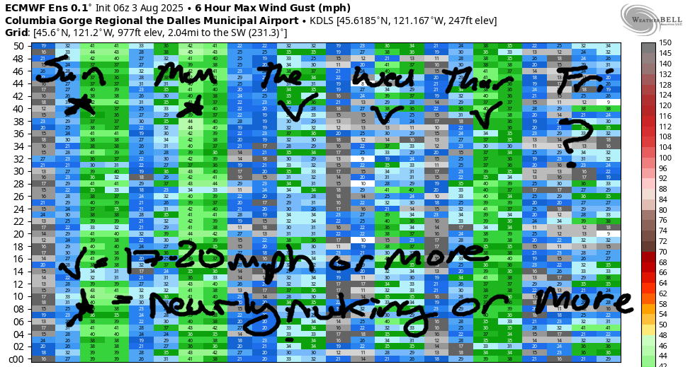
Hi friends! Quite the fun day was had yesterday, and another rather fun day is on tap today. Same for tomorrow – windy! As a matter of fact, we’re looking at 17-20mph or more all the way through at least next Friday. Next weekend looks questionable thanks to heating, but there’s a ton of range in the forecasts still, so we can’t write it off yet. Today’s PSA: I forgot to mention the sailboat races yesterday. There will be sailboat races again today between the Hood River Marina and the lower Hatch buoy. Please avoid the area if you can, and if you can’t (you can, I swear you can!), please give way to the racers.
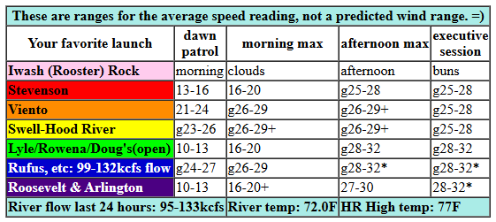
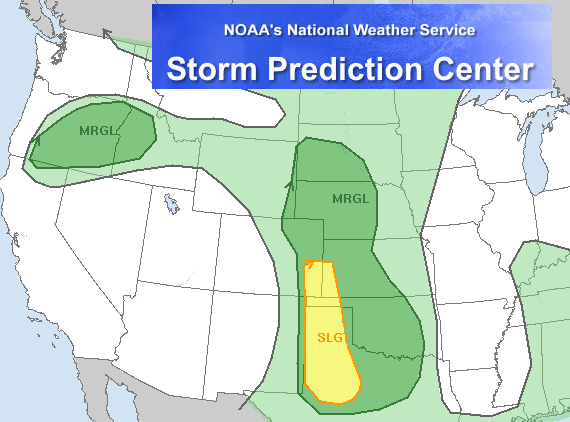
All righty… Sunday morning… Pressures were 30.19/30.07/30.03 for gradients of 0.12 (PDX-DLS) and 0.04 (DLS-PSC). Portland was socked in and fully cloudy. High clouds aloft indicated a weather system pushing this way. For the desert, the Storm Prediction Center predicts instability and thunderstorms. Westerlies started the day at 23-26mph from Viento to the Hatch with 13-16mph at Stevenson and the Rowena zone. For the Maryhill stretch, the day started with 23-26mph on the iWind/iKite sensors (which is equivalent to 19-22 at Swell). Westerlies will pick up today, but the moving pieces are likely to make the wind up-and-down, extra gusty, and any thunderstorms out east could shut things down out there.
So… morning westerlies build to gusty, up-and-down 25-28mph from Viento to Mosier with 22-25mph from Rowena to Rufus. Afternoon wind holds at 26-29mph and fills in from Stevenson to Mosier with 28-32mph from Lyle to Rufus (atmospheric stability permitting!) After 2pm and into the evening, the wind rises to 28-32mph from Arlington to Threemile, assuming thunderstorms don’t pop up and shut things down. River flow over the last 24 hours was 95-133kcfs (99-132kcfs at Rufus), river temp is 72.0F (poor salmon!), and high temp forecast is 77F for Hood River and 86F for Rufus.
RIVER FLOW FOR SITES BETWEEN AVERY (EAST OF THE DALLES) AND RUFUS: CLICK HERE FOR JOHN DAY DAM FLOW.
RIVER FLOW FOR SITES BETWEEN STEVENSON AND DOUG’S BEACH (WEST OF THE DALLES): CLICK HERE FOR THE DALLES DAM FLOW

tomorrow’s gorge wind forecast
Monday sees this cool air trough really settle in. Result: deep, long-lasting marine clouds on the west side. We’ll also see a mix of high and mid-level clouds in the morning Despite this, it’ll be windy right off the bat: 26-29mph from the end of the low clouds (Swell? Mosier?) to Avery with 23-26mph from Celilo to Arlington. Afternoon wind rises to 28-32mph from Viento to Rufus with 26-29mph at Arlington. Stevenson is likely to stay cloudy all day with gusty 15-19mph. High temp: 74F for Hood River and 84F for Rufus.
extended Gorge wind forecast
A bunch of moving pieces on Tuesday creates a less reliable and gustier setup. Clouds increase during the day and shift the wind east. The day starts with 18-22mph from Stevenson to Threemile. It’ll take a while to really get going, but we’ll eventually have gusty 26-29mph from Lyle to Arlington with less on the west side. There may be a period of this stronger wind near the Hatch before clouds really push in, but it’ll be short-lived. By afternoon, the Stevenson-Hood River zone will be below 15mph, most likely. High temp: 80F for Hood River and 87F at Rufus.
Models continue with westerlies Wednesday through Friday, although there’s a fair bit of range in the actual wind speed. The Euro ensemble has Thursday as the strongest day, but the GFS deterministic does not. Either way… it’ll be windy. Hotter weather is forecast next weekend, but there’s quite a bit of range in the possible outcomes. This makes it impossible to predict the wind; it all depends on where the ridge sets up and what part of the region is hottest. For now, we’ll just have to exercise patience! Have a great day on the river today!
Was that helpful? I knew it was! Guess what? All of this crucial work – from your personal wind and snow reports to the invaluable TATAS updates – is made possible by my relentless efforts. Maintaining this labor of love isn’t easy. Each daily forecast takes hours. Website hosting, weather model access, and back-end admin work takes time and money. That’s where you come in.
YOUR CONTRIBUTION MAKES A DIFFERENCE
- SUPPORT ACCURATE, HYPER-LOCAL WEATHER FORECASTING
- ENABLE ACCESS FOR ALL, EVEN THOSE WITH LESS MEANS
- SUPPORT A COOL HUMAN WHO WORKS HARD SO YOU CAN PLAY
Take a moment to click one of the buttons below. Donate $19.99 or more (how much does this forecast enhance your life?) and get the email in your inbox. Whether it’s a renewing subscription (auto-renew) or a one-time donation, every contribution makes a real difference. Help me keep this labor of love alive, so we can all continue playing, commuting, and living in the Gorge with peace of mind and the best weather forecasts possible. Thank you!


Hood River, Oregon 97031


JONES BEACH, SAUVIE ISLAND, & COAST FORECAST
Wind northerly unless otherwise indicated. For coast, it’s North/Central/South with the “central” at approximately Florence. Swell forecast from NWS for central coast. Jones: westerly unless otherwise stated. Sauvie Island: northerly unless otherwise stated. Coast Sunday: NNW10-15/N15/N25, SW swell 2′ at 17 seconds. Monday: LTNW/N10-15/N20, SW 2′ @ 17. Tuesday: LTW/LTNW/N20, SW 2′ @ 15. Jones Sunday: 14-17. Monday: 7-10. Tuesday: 14-17. Sauvie Island Sunday: 9-11. Monday: 7-10. Tuesday: LTV.
BARE BONES HOOD RIVER WEATHER FORECAST
Partly high overcast this morning and mostly clear later. Temps start in the low 60s and rise to the upper 70s. Strong westerlies. No rainbows. Monday will be cloudy then mostly clear. Temps start in the mid 50s and rise to the mid 70s. Strong westerlies. No rainbows. Tuesday will be partly cloudy early and mostly cloudy later. Temps start in the upper 50s and rise to the low 80s. Moderate westerlies. No rainbows.
TEMIRA’S AWESOME TRAVEL ADVISORY SERVICE – SUNDAY 8/3
HYPERLOCAL WEATHER FORECAST FOR THE COLUMBIA GORGE
THE DALLES, HOOD RIVER, WHITE SALMON, TROUT LAKE, STEVENSON, CASCADE LOCKS, PARKDALE, ODELL, HUSUM, BZ, MILL A, WILLARD, GOLDENDALE, RUFUS, ARLINGTON, boardman
Good morning, neighbors! Cool(ish) weather sticks around through Thursday. Uncertainty in the form of 7-10 degrees of range kicks in starting Friday, but next weekend will almost certainly be hot. How hot? Depends on where the ridge of high pressure sets up, but triple digits are possible next Sunday. Know what else is possible this week? A bit of drizzle or a few sprinkles on Wednesday and thunderstorms today in the desert! Wow. That was all over the place. Let’s do the forecast discussion and clear up some of the confusion, shall we?
GLENWOOD THIS MORNING
But first, Glenwood. It was a chilly start there this morning: 44 degrees, about half the degrees in my coffee and half the degrees of today’s high temp at Biggs, where Biggie Smalls used to go to shop at Big n’ Tall. In Glenwood this morning, sheep are wandering around chilly, wishing they hadn’t been shorn, and the humans are happily wearing their brown mittens made from the wool of those sheep.
TODAY’S GORGE WEATHER FORECAST
For the rest of Sunday for the rest of us, it’ll be windy and partly high overcast. Temps end up in the upper 70s (west), mid 80s (The Dalles), and low 90s (out where the watermelons moan and groan). We’ll see west wind at 25-30mph all day from Stevenson to Mosier with 25-30mph from Stevenson to the Arlington Triangle this afternoon. East of the Cascade Crest, there’s a chance of thunderstorms this afternoon. Head a bit south into north-central Oregon, and you’ll run into a marginal risk of severe storms. That’s exciting! Let’s all cross our fingers for no cloud-to-ground strikes and no more fires.
MONDAY’S GORGE WEATHER FORECAST
Overnight, thanks to a trough pushing inland, deep low clouds stack up along the Cascades. Those are joined by mid and high clouds all the way east into the desert. While we’re not expecting rain, we are expecting cooler temps: mid 50s to start the day. Afternoon: low to mid 70s on the west side, low 80s near The Dalles, and mid to upper 80s out in the desert. West wind will be 25mph to start between Viento and Celilo Village. Afternoon wind: 25-35mph from Stevenson to the Arlington Triangle.
TUESDAY’S GORGE WEATHER FORECAST
A low pressure system lingers near BC on Tuesday, and weak troughing (call it cool air, to keep it simple) sticks around for us. This starts the day at 60 degrees or less with partly high overcast sky and a pretty sunrise. Clouds push in during the day as a weak weather system associated with the BC system moves inland. West wind will be 15-20mph from Stevenson to Boardman in the morning with 25-30mph from Lyle to Arlington in the afternoon. Highs will be 80 on the west side, 85 near The Dalles, and 90 degrees out where the watermelons are rolling over in the fields trying to stay warm.
EXTENDED GORGE WEATHER FORECAST
There’s a wee chance of sprinkles and an even weenier chance of actual rain on Wednesday, at least for us here in the Gorge. Cool temps linger through Friday. By cool, I mean under 80 for Hood River and under 90 for The Dalles. Next weekend looks hot, and it also looks not-all-that-windy, for once. Let’s leave it there for now. I have a Wind Johnny forecast to write. Safe travels. -TATAS
HEY! DON’T STOP READING! Is this community-focused forecast helpful to you? It sure is! It takes me a couple hours a day to write. Please join your friends and neighbors in contributing to keep it going. Venmo: @thegorgeismygym PayPal: twomirrors@gmail.com USPS: Temira / PO Box 841 / Hood River, Oregon 97031 You can test out the forecast subscription for a few days for free by signing up below. Easy! Do it!
