

GORGE WIND FORECAST
today’s gorge wind forecast
Hi friends! It’s a sunny, light wind start to the day here in the Gorge, and the wind will pick up just enough this afternoon to get many of you on the water. Same thing tomorrow. As a heat low shifts inland on Tuesday, we’ll see stronger wind that persists into Wednesday. From Thursday on, uncertainty is surprisingly high, with some ensemble members calling for very little wind, and some calling for lots. There’s no way to give you an accurate Gorge wind forecast beyond Wednesday, so I won’t mess with your head by trying!
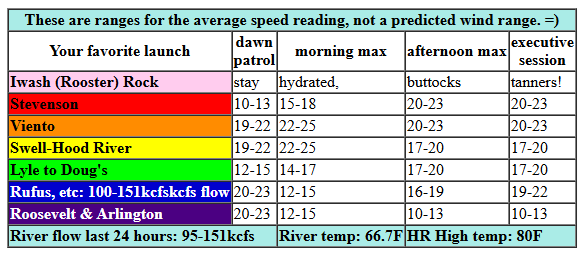
Sunday started with pressures of 30.19/30.12/30.11 for gradients of 0.07 (PDX-DLS) and 0.01 (DLS-PSC). Metro area sky was clear as can be; the heating race is on between the desert and the west side. We won’t have much thermal help today – just a few degrees of difference are forecast. That will take the wind speeds down from what we’ve seen recently. The day started with 17-20mph at Viento and less than 10mph everywhere else. We’ll see a slow build to 16-19mph between Stevenson and Hood River by early afternoon with 13-16mph at Mosier and less than 10mph to the east. The wind holds until the Executive Session (after 5pm), when it rises to 17-20mph between Stevenson and Mosier with 11-14 between Lyle and Doug’s. River flow over the last 24 hours was 95-142kcfs, river temp is 66.9F, and high temp forecast is 88F for Hood River.
RIVER FLOW FOR SITES BETWEEN AVERY (EAST OF THE DALLES) AND RUFUS: CLICK HERE FOR JOHN DAY DAM FLOW.
RIVER FLOW FOR SITES BETWEEN STEVENSON AND DOUG’S BEACH (WEST OF THE DALLES): CLICK HERE FOR THE DALLES DAM FLOW

tomorrow’s gorge wind forecast
Our next mini heat wave really digs in on Monday; we’ll be relying on afternoon thermal gradients to get things going. Expect very little wind to start, perhaps 10-13mph between Stevenson and Swell. East of there: calm. We’ll see a slow build to 15-18mph from Stevenson to Mosier by early afternoon. The wind fills in between Stevenson and Doug’s at 17-20mph late in the afternoon, holding into the evening. High temp: 94F and sunny.
extended Gorge wind forecast
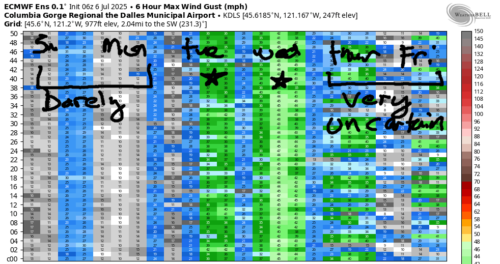
Heat sticks around Tuesday, but the associated heat low pressure is expected to shift east of the Cascades in the afternoon with strong wind resulting. Early wind should be 21-24mph from Stevenson to Mosier with 12-15mph east to Arlington. By late morning, we’ll have 24-27mph from Stevenson to Mosier with 20-23mph form Lyle to Doug’s and 11-14mph at Avery. Afternoon wind, thanks to lack of marine cloud support in the west, drops to gusty, up-and-down 18-23mph at Swell and rises to 25-28mph between Mosier and Rufus. There’s some possibility of 28-32mph in the evening, but it’s far from guaranteed. Let’s keep watching to see how this plays out, shall we? High temp: 92F for Hood River.
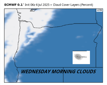
Marine clouds surge into the west side early Wednesday and may actually keep pushing inland during the morning. If this plays out, you’ll be driving east of those clouds for best results. Desert wind should rise to 30mph in the afternoon. I’m going to hold off on making a prediction for the Corridor and Near East (Swell through Doug’s) until we have a better sense of what those clouds will do. Either way, it’s going to be a windy day; it’s just a matter of where! Uncertainty increases on Thursday and lingers into the long-range forecast. At this point, it’s not possible for me to give you a forecast for Thursday and beyond – the range of possibilities is just too big. So, let’s leave it there for now. Have a great day on the water!
Was that helpful? I knew it was! Guess what? All of this crucial work – from your personal wind and snow reports to the invaluable TATAS updates – is made possible by my relentless efforts. Maintaining this labor of love isn’t easy. Each daily forecast takes hours. Website hosting, weather model access, and back-end admin work takes time and money. That’s where you come in.
YOUR CONTRIBUTION MAKES A DIFFERENCE
- SUPPORT ACCURATE, HYPER-LOCAL WEATHER FORECASTING
- ENABLE ACCESS FOR ALL, EVEN THOSE WITH LESS MEANS
- SUPPORT A COOL HUMAN WHO WORKS HARD SO YOU CAN PLAY
Take a moment to click one of the buttons below. Donate $19.99 or more (how much does this forecast enhance your life?) and get the email in your inbox. Whether it’s a renewing subscription (auto-renew) or a one-time donation, every contribution makes a real difference. Help me keep this labor of love alive, so we can all continue playing, commuting, and living in the Gorge with peace of mind and the best weather forecasts possible. Thank you!


Hood River, Oregon 97031


Was that helpful? I knew it was! Guess what? All of this crucial work – from your personal wind and snow reports to the invaluable TATAS updates – is made possible by my relentless efforts. Maintaining this labor of love isn’t easy. Each daily forecast takes hours. Website hosting, weather model access, and back-end admin work takes time and money. That’s where you come in.
YOUR CONTRIBUTION MAKES A DIFFERENCE
- SUPPORT ACCURATE, HYPER-LOCAL WEATHER FORECASTING
- ENABLE ACCESS FOR ALL, EVEN THOSE WITH LESS MEANS
- SUPPORT A COOL HUMAN WHO WORKS HARD SO YOU CAN PLAY
Take a moment to click one of the buttons below. Donate $19.99 or more (how much does this forecast enhance your life?) and get the email in your inbox. Whether it’s a renewing subscription (auto-renew) or a one-time donation, every contribution makes a real difference. Help me keep this labor of love alive, so we can all continue playing, commuting, and living in the Gorge with peace of mind and the best weather forecasts possible. Thank you!
Hood River, Oregon 97031
JONES BEACH, SAUVIE ISLAND, & COAST FORECAST
Wind northerly unless otherwise indicated. For coast, it’s North/Central/South with the “central” at approximately Florence. Swell forecast from NWS for central coast. Jones: westerly unless otherwise stated. Sauvie Island: northerly unless otherwise stated. Sunday: 20-25/25-30/30-35, W swell 3′ at 10 seconds. Monday: 20/20/20-25, W 3′ @ 9. Tuesday: NW10/NW10/LTV, W 3′ @ 8. Jones Sunday: 19-22. Monday: 21-24. Tuesday: 22-25. Sauvie Island Sunday: 15-18. Monday: 14-17. Tuesday: 12-15.
BARE BONES HOOD RIVER WEATHER FORECAST
Clear sky all day. Temps start in the low 60s and rise to the upper 80s. Light westerlies early. Moderate later. No rainbows. Monday will be sunny. Temps start near 60 and rise to the mid 90s. Light westerlies early. Moderate later. No rainbows. Tuesday will be sunny. Temps start in the low 60s and rise to the low 90s. Moderately strong westerlies. No rainbows.
TEMIRA’S AWESOME TRAVEL ADVISORY SERVICE – 7/6 SUNDAY
HYPERLOCAL WEATHER FORECAST FOR THE COLUMBIA GORGE
THE DALLES, HOOD RIVER, WHITE SALMON, TROUT LAKE, STEVENSON, CASCADE LOCKS, PARKDALE, ODELL, HUSUM, BZ, MILL A, WILLARD, GOLDENDALE, RUFUS, ARLINGTON, boardman
Good morning, neighbors! Our forecast is full of blue sky and sunshine into Tuesday, at least. A couple cooler days Wednesday and Thursday might even bring some clouds. After that, uncertainty is high around the details, but the general picture has us sunny and dry and rather warm for the extended forecast period. I mean, duh. It’s summer. You probably could have made that forecast!
today’s gorge weather forecast
Sunday starts sunny and ends sunny, and clear sky sticks around all day. A few high clouds in the evening east of the Cascade Crest will add some color to the sunset. Temps max out in the upper 80s (west) and low 90s (east), which means you should be storing up cold air in your home right now and planning a BBQ rather than stove-top cooking this evening. Wind will be light this morning. Afternoon westerlies pick up to 15-20mph between Stevenson and Mosier with 10-15mph between Lyle and Murdoch with light wind to the east.
monday gorge weather forecast
Monday looks almost identical to Sunday other than the temps, which will be hotter, hot enough that I might start whining about them even though there’s nothing to do other than find a cool spot in the woods near a waterfall or a cool spot in a grocery store in the ice cream aisle. Afternoon highs: 94 to the west and 99 to the east. Wind: light early and 15-20mph west of The Dalles later.
tuesday gorge weather forecast
Tuesday will still be hot and sunny, but we’ll add some instability east of the Cascade Crest (which is different than the Cascade Aim or the Cascade Colgate or the Cascade Tom’s of Maine or Cascade plain-old-baking-soda) and stronger west wind: 20-25mph from Stevenson to Mosier in the morning and 25-30mph from Stevenson to the Arlington Circle, Square, Triangle by the Test Icicles. Or was it the Arlington Bizarre Love Triangle? Well, either way, it’s gonna be hot out there: over 100 degrees. West side: 98. Watermelon zone: 104.
extended gorge weather forecast
Clouds push into the west side Wednesday morning like a well-lubricated butt plug going where the sun don’t shine. It’s unclear how far inland the clouds will penetrate, so I can’t yet tell you where to go to escape Sol other than up your butt, which is where the sun never shines. Know where the sun always shines? On TV. Thanks to the clouds, a massive thermal gradient develops across the Cascades, and the gap winds really get going. Expect very strong westerlies and high fire danger. Beyond Wednesday, uncertainty rears its friendly head; ensembles have a 10 degree spread (or more) in the possible high temps. I refuse to forecast under these conditions. Instead, I’m going to go spend more time finding songs with the word “triangle” in the title. Safe travels. -TATAS
OMG, I ALMOST FORGOT GLENWOOD. IT WAS 41 DEGREES THERE THIS MORNING!!!!!!
HEY! DON’T STOP READING! Is this community-focused forecast helpful to you? It sure is! It takes me a couple hours a day to write. Please join your friends and neighbors in contributing to keep it going. Venmo: @thegorgeismygym PayPal: twomirrors@gmail.com USPS: Temira / PO Box 841 / Hood River, Oregon 97031 You can test out the forecast subscription for a few days for free by signing up below. Easy! Do it!
