

GORGE WIND FORECAST
If you’re still seeing yesterday’s and it’s after 9am, try opening this in an incognito window
today’s gorge wind forecast
Hi friends! Know those fall days where everything lines up and the Gorge goes off? This is looking like one of those days: a cold front moves inland, a low pushes our way, clouds linger on the west side, and very strong wind is forecast at 850mb (5000′). Get it today if you can. The next chance for west wind is Wednesday, and that chance is unreliable. Beyond that: not much sign of a big day as conditions turn quite wet and much cooler.
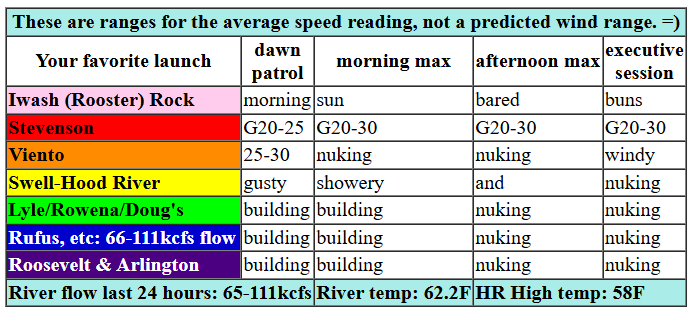
Looking at Sunday around dawn, we had pressures of 29.93/29.83/29.80. Pretty good to start, and only the start of things. We’ll have a couple hours of gusty, showery conditions as a cold front moves through this morning. Rain lingers west of Mosier (intermittently, anyway) all day making conditions gusty there. Still… 25-30mph, big gusts, and big swell are likely at the Hatch and Hood River and Mosier thanks to nuking wind at Viento. Stevenson will be even wetter and even less reliable for wind, but still should be over 20mph this afternoon.
Out east is where you’ll find the madness: 30-40mph with huge gusts from late morning or early afternoon into early evening. Nuking wind extends all the way from Lyle to the Idaho border. Models do hint at rain pushing past The Dalles after 2pm, which would impact the wind near Doug’s. Best bet today is east of Celilo, and make sure you bring your A game. Consider a PFD, and keep an eye on your buddies. River flow over the last 24 hours was 65-111kcfs, river temp is 62.2F, and high temp forecast is 58F in Hood River and 63F out in the desert.
RIVER FLOW FOR SITES BETWEEN AVERY (EAST OF THE DALLES) AND RUFUS: CLICK HERE FOR JOHN DAY DAM FLOW.
RIVER FLOW FOR SITES BETWEEN STEVENSON AND DOUG’S BEACH (WEST OF THE DALLES): CLICK HERE FOR THE DALLES DAM FLOW

tomorrow’s gorge wind forecast
Lingering westerlies early Monday might last just long enough for a Viento-Hood River dawn patrol. By late morning, the wind turns calm and stays that way. High temp: 61F and sunny.
extended Gorge wind forecast
Tuesday brings inland high pressure and offshore wind. Stevenson maxes out at 20mph mid-morning, and Iwash (Rooster) Rock maxes out at 25mph. Viento will be 15-20mph. As often happens, the wind will fade in the afternoon. Iwash finishes with 15-20mph, and Stevenson finishes with 15mph. High temp: 65F in Stevenson and likely cooler in Hood River thanks to an inversion. Models suggest just gusty westerlies around 20mph on Wednesday, strongest near Rowena, as a weather system approaches. Beyond Wednesday, the weather looks quite wet and cool with not much opportunity for wind. Maybe that will change next weekend if some of the paths of the systems shifts. Fingers crossed! Be safe out there today. See you on the Nch’i Wana!
Was that helpful? I knew it was! Guess what? All of this crucial work – from your personal wind and snow reports to the invaluable TATAS updates – is made possible by my relentless efforts. Maintaining this labor of love isn’t easy. Each daily forecast takes hours. Website hosting, weather model access, and back-end admin work takes time and money. That’s where you come in.
YOUR CONTRIBUTION MAKES A DIFFERENCE
- SUPPORT ACCURATE, HYPER-LOCAL WEATHER FORECASTING
- ENABLE ACCESS FOR ALL, EVEN THOSE WITH LESS MEANS
- SUPPORT A COOL HUMAN WHO WORKS HARD SO YOU CAN PLAY
Take a moment to click one of the buttons below. Donate $19.99 or more (how much does this forecast enhance your life?) and get the email in your inbox. Whether it’s a renewing subscription (auto-renew) or a one-time donation, every contribution makes a real difference. Help me keep this labor of love alive, so we can all continue playing, commuting, and living in the Gorge with peace of mind and the best weather forecasts possible. Thank you!


Hood River, Oregon 97031


BARE BONES HOOD RIVER WEATHER FORECAST
Rain today with a few breaks becoming merely showery later. Temps start in the low 50s and rise to the upper 50s. Strong westerlies. 99% chance of rainbows. Monday starts with low clouds and turns clear. Temps start in the low 40s and rise to the low 60s. Light/variable wind. No rainbows. Tuesday will be partly Nothing then clear. Temps start in the upper 30s and rise to the mid 60s. Light easterlies. No rainbows.
TEMIRA’S AWESOME TRAVEL ADVISORY SERVICE
HYPERLOCAL WEATHER FORECAST FOR THE COLUMBIA GORGE
THE DALLES, HOOD RIVER, WHITE SALMON, TROUT LAKE, STEVENSON, CASCADE LOCKS, PARKDALE, ODELL, HUSUM, BZ, MILL A, WILLARD, GOLDENDALE, RUFUS, ARLINGTON, boardman

Good morning, neighbors! Exciting day on tap here in the Gorge (well, I’m at Cloud Mountain right now, but you know what I mean): plenty of rain for the west side, lots of rainbows, and tons of wind for pretty much everyone no matter your location or elevation. Up in the mountains: super stormy and snowy above 5000. Things, at least weather things, calm down on Monday and stay rather calm through Wednesday. Starting Thursday, rain returns. Looking at next weekend: if the forecast holds, the mountains could pick up significant (1-2 feet) of snow above 4000′. Fingers crossed!
Looking at this morning… uh, I’m not there, but webcams show clouds all the way out into the desert. Glenwood is 45 degrees, rather mild, which is boring, because spicy is better than mild! Today’s weather is going to get spicy. A cold front is on its way eastward, and strong wind aloft combines with high pressure offshore to drive a very windy Gorge day. Rain continues all day west of Hood River and extends to Celilo Village at times this afternoon and evening. Out in the desert, the sky eventually clears. Sometime midday, the wind turns “nuking”: west 25-35mph west of Mosier and 30-40mph with bigger gusts east of Mosier pretty much all the way to the border with Idaho. The border wall between Oregon, Washington, and Idaho is made of potatoes. Isn’t that cool? Temps today finish up in the upper 50s on the west side and 62-64F from The Dalles eastward.
Everything settles down tonight as high pressure builds inland. Monday starts with low clouds to the west and clear sky to the east with lingering light to moderate west wind. Afternoon brings mostly clear sky and calm wind with temps in the low 60s all across the lowlands.
We’ll have a shot at patchy frost on Tuesday morning in the usual cold spots thanks to clear sky and light east wind. While models suggest highs will be in the mid 60s, they also indicate a developing inversion. That, along with east wind at 20-25mph (Iwash/Stevenson) could keep things cooler than forecast east of Wyeth. Sky coverage: mostly clear all day after a partial Nothing start near the Nch’i Wana River.
Wednesday’s a transition day as an approaching front turns the wind onshore and maybe drags in some clouds. “Exciting” weather returns Thursday into the weekend with the potential for lots of rain in the lowlands. Up in the mountains, as I mentioned earlier, lots of snow could (please!) fall. Yay. Safe travels. -TATAS
HEY! DON’T STOP READING! Is this community-focused forecast helpful to you? It sure is! It takes me a couple hours a day to write. Please join your friends and neighbors in contributing to keep it going. Venmo: @thegorgeismygym PayPal: twomirrors@gmail.com USPS: Temira / PO Box 841 / Hood River, Oregon 97031 You can test out the forecast subscription for a few days for free by signing up below. Easy! Do it!
MT HOOD SNOW FORECAST

CURRENTLY ON VACATION. WILL RETURN SOMETIME BEFORE THE START OF SKI SEASON AT MEADOWS, TIMBERLINE AND SKIBOWL. SAME GOES FOR THE NORDIC SKIING SEASON AT MEADOWS AND TEACUP!
JONES BEACH, SAUVIE ISLAND, & COAST FORECAST
ON WINTER VACATION. WILL RETURN AS NEEDED.
