

GORGE WIND FORECAST
today’s gorge wind forecast
Hi friends! It’s Sunday, and the Gorge wind forecast for today has backed way off since yesterday’s models runs. Looks like it’s a rest day. Westerlies return on Monday and build into next week with peak wind likely Wednesday and Thursday. Extended models keep the wind going through next weekend. With temps forecast to fall to 70 or less by the end of the week and cloud cover likely on the west side, we might be shifting our attention east of Hood River for much of next week. But for now…
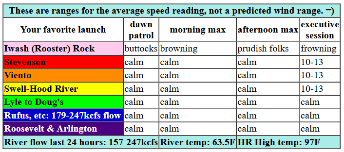
Let’s start with today. It’s glassy in front of my house this morning, and gradients mirrored the mirror-like river: 29.98/29.97/30.00. Essentially flat. Calmish conditions hold into the afternoon. Models suggest 10-13mph this evening from Stevenson to Hood River, just enough to stir up a nearly triple-digit breeze. River flow over the last 24 hours was 157-247kcfs, river temp is 63.5F, and high temp forecast is 97F for Hood River.

tomorrow’s gorge wind forecast
Hot weather continues on Monday, but the WA/OR desert will be 10 degrees warmer than it was on Sunday. The onshore thermal gradient gives us onshore wind: Dawn Patrol looks like 16-19 from Viento to Swell. It’s likely the wind will drop to 13-16 for a few hours before returning at 20-23 from Stevenson to Doug’s late morning. In the afternoon, most places between Stevenson and Rufus rise to 21-24. Swell and Hood River are the exceptions – they’ll likely fall to 17-20. High temp: 96F for Hood River and 104F for Pasco.
extended Gorge wind forecast
As the ridge causing the hot weather shifts east, the west side temps drop a few degrees on Tuesday. In the desert, temps rise 10 degrees! This gives us 21-24ish all day from Stevenson to Mosier. Avery joins in the afternoon. Rufus picks up to 17-20 in the afternoon, and Arlington gets a bit of a breeze with 10-13 late in the day. High temp: 90 F for Hood River and 101F for Pasco.
More significant cooling is forecast Wednesday and Thursday. Westerlies respond with upper 20s to low 30s. Models have backed off a little on the wind strength for both days (it appears there will be less marine layer than initially forecast), but they both appear strong. Solid westerlies continue (probably) through next weekend. Stay safe in the heat today, and I’ll see you in some swimming hole somewhere!
Was that helpful? I knew it was! Guess what? All of this crucial work – from your personal wind and snow reports to the invaluable TATAS updates – is made possible by my relentless efforts. Maintaining this labor of love isn’t easy. Each daily forecast takes hours. Website hosting, weather model access, and back-end admin work takes time and money. That’s where you come in.
YOUR CONTRIBUTION MAKES A DIFFERENCE
- SUPPORT ACCURATE, HYPER-LOCAL WEATHER FORECASTING
- ENABLE ACCESS FOR ALL, EVEN THOSE WITH LESS MEANS
- SUPPORT A COOL HUMAN WHO WORKS HARD SO YOU CAN PLAY
Take a moment to click one of the buttons below. Donate $19.99 or more (how much does this forecast enhance your life?) and get the email in your inbox. Whether it’s a renewing subscription (auto-renew) or a one-time donation, every contribution makes a real difference. Help me keep this labor of love alive, so we can all continue playing, commuting, and living in the Gorge with peace of mind and the best weather forecasts possible. Thank you!


Hood River, Oregon 97031


JONES BEACH, SAUVIE ISLAND, & COAST FORECAST
Wind northerly unless otherwise indicated. For coast, it’s North/Central/South with the “central” at approximately Florence. Swell forecast from NWS for central coast. Jones: westerly unless otherwise stated. Sauvie Island: northerly unless otherwise stated. Sunday: 15/15/15-20, NW swell 5′ at 9 seconds. Monday: 15-20/20-25/25-30, NW 7′ @ 10. Tuesday: 20/20/25, NW 8′ @ 10. Jones Sunday: 22-25. Monday: 23-26. Tuesday: 24-27. Sauvie Island Sunday: 12-15. Monday: 16-19. Tuesday: 15-18.
BARE BONES HOOD RIVER WEATHER FORECAST
Clear sky all day today. Temps start in the upper 50s and rise to the upper 90s. Very light west wind, calm at times. No rainbows Monday will be clear. Temps start in the upper 60s and rise to the upper 90s. Moderate westerlies. No rainbows. Tuesday will be mostly clear. Temps start in the low 60s and rise to 90 or so. Moderately strong westerlies. No rainbows.
TEMIRA’S AWESOME TRAVEL ADVISORY SERVICE
HYPERLOCAL WEATHER FORECAST FOR THE COLUMBIA GORGE
THE DALLES, HOOD RIVER, WHITE SALMON, TROUT LAKE, STEVENSON, CASCADE LOCKS, PARKDALE, ODELL, HUSUM, BZ, MILL A, WILLARD, GOLDENDALE, RUFUS, ARLINGTON, boardman

Good morning, neighbors! Hot to fucking hot weather is in the cards today and tomorrow, and “really hot” weather continues on Monday. After that, thankfully, a cooldown arrives. By Friday, we’ll have a shot at highs BELOW 70 degrees. In the meantime… a few heat-related records may fall, especially on Monday morning when the record high-low (65 degrees) is in jeopardy. Ditto for Tuesday, when the record high-low is 61 degrees. Records are for Hood River, btw, because that’s what I have easiest access to.
Sunday’s Gorge weather forecast and Glenwood’s start to the day
Sunday just looks hot. Fucking hot. That’s for here. Out in the desert, it’ll be way fucking hotter on Monday as the ridge of high pressure shifts east. Even Glenwood started the day warm today: 51 degrees. Folks were sipping cold-brew coffee on the porch while wearing shades and eating strawberry coffee cake. Next week they’ll be eating raspberry coffee cake, and the week after that they’ll be munch on blueberry coffee cake. Hopefully they’ll share with the rest of us! Back to the heat… everyone gets upper 90s today under clear sky. In yesterday’s forecast, we had some wind today. Now we don’t. Expect calmish conditions all the way into the evening, when westerlies finally pick up to 10mph or so west of Mosier.
Monday’s gorge weather forecast
As the ridge shifts east on Monday, temps don’t fall for the Gorge. Out near Pasco, temps max out near 104 on Monday after only making it to 94 on Sunday. Pasco should get a prize for a 10 degree jump day-over-day. Closer to home… the difference in heat between the west side and east side triggers westerlies that strongly resemble life in a convection oven. 15mph early from Viento to Hood River with 20-25mph in the afternoon between Stevenson and Bob’s Texas T-Bone, the location once known as Rufus and now known as Steakland. Oh, I forgot to mention the low temps on Monday morning. They won’t be very low – the current forecast is 67 degrees. That means you’ll be blasting the AC on Sunday night if you’re lucky enough to have AC.
extended gorge weather forecast
Tuesday’s start also looks warm – low 60s. Dewpoint: 52. Muggy. High temps rise to the 90-95 zone. Thankfully, there will be a breeze: 20-25mph between Stevenson and Mosier in the morning with 20-25 from Stevenson to The Dalles in the afternoon and 15-20 near Rufus. Cooler, windy weather is forecast Wednesday into next weekend. Rain chances are basically zero all the way through next weekend. About half of the ensemble members have a little rain the following week, but chances look minimal at this point for anything that would damage cherries. We’ll keep a close eye on it! Safe travels. -TATAS
HEY! DON’T STOP READING! Is this community-focused forecast helpful to you? It sure is! It takes me a couple hours a day to write. Please join your friends and neighbors in contributing to keep it going. Venmo: @thegorgeismygym PayPal: twomirrors@gmail.com USPS: Temira / PO Box 841 / Hood River, Oregon 97031 You can test out the forecast subscription for a few days for free by signing up below. Easy! Do it!
