

GORGE WIND FORECAST
If you’re still seeing yesterday’s and it’s after 9am, try opening this in an incognito window
today’s gorge wind forecast
Hi friends! We’ve fallen into a full-on fall weather pattern – several weather systems are forecast to come through over the next few days, and then a winter-strength low pressure system swirls off the coast for the next couple of days after that. With some warmth in the desert and occasional nudges from these weather systems, the Gorge wind forecast contains some wind but not our summer-like, steady, all-day westerlies.
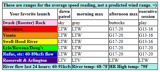
Sunday kicked off with very light onshore pressure (29.98/29.97) and light/variable or calm wind all through the Gorge. As a warm front swings through today and desert heating outpaces the west side, westerlies pick up. Early afternoon brings 11-14mph from Stevenson to Hood River. For the mid-afternoon period, we’ll see gusty 17-20mph from Stevenson to Rufus, strongest near Doug’s and Avery. East of Rufus: light wind. River flow over the last 24 hours was 60-91kcfs, river temp is 68.7F, and high temp forecast is 79F under high overcast sky.
RIVER FLOW FOR SITES BETWEEN AVERY (EAST OF THE DALLES) AND RUFUS: CLICK HERE FOR JOHN DAY DAM FLOW.
RIVER FLOW FOR SITES BETWEEN STEVENSON AND DOUG’S BEACH (WEST OF THE DALLES): CLICK HERE FOR THE DALLES DAM FLOW

tomorrow’s gorge wind forecast
Another weather system, a cold front this time, is planned for Monday. This system triggers a drop in pressure east of the Cascades in the afternoon. Combine that with some temp gradient for somewhat strong, but still very gusty and unreliable, west wind. The day starts calm. By late morning, we’ll have gusty 13-16mph from Stevenson to Hood River with 17-20mph from Mosier to Doug’s. This is ahead of incoming rain. As the rain shifts east, so does the wind. We finish with gusty 20-23mph from Mosier to Rufus. High temp: 72F for Hood River and 77F for Rufus.
extended Gorge wind forecast
On Tuesday, a massive low pressure system spins up in the offshore waters. A stronger frontal system approaches during the day and moves through in the evening. Wind will be calm to start and (perhaps) gusty 11-14mph in the afternoon. Not much to talk about here. High temp: 69F. Not much happens Through Friday as that low lingers offshore and sends systems into the Gorge. There are some hints of stronger westerlies on Friday (not so likely) or Saturday (somewhat more likely), but generally speaking, models are less-than-excited about the next two weeks. More exciting is the possibility of improved mountain biking conditions and a solid early rain to really fire up the fall foraging season. Have a great day, everyone. See you out there for some sort of fun!
Was that helpful? I knew it was! Guess what? All of this crucial work – from your personal wind and snow reports to the invaluable TATAS updates – is made possible by my relentless efforts. Maintaining this labor of love isn’t easy. Each daily forecast takes hours. Website hosting, weather model access, and back-end admin work takes time and money. That’s where you come in.
YOUR CONTRIBUTION MAKES A DIFFERENCE
- SUPPORT ACCURATE, HYPER-LOCAL WEATHER FORECASTING
- ENABLE ACCESS FOR ALL, EVEN THOSE WITH LESS MEANS
- SUPPORT A COOL HUMAN WHO WORKS HARD SO YOU CAN PLAY
Take a moment to click one of the buttons below. Donate $19.99 or more (how much does this forecast enhance your life?) and get the email in your inbox. Whether it’s a renewing subscription (auto-renew) or a one-time donation, every contribution makes a real difference. Help me keep this labor of love alive, so we can all continue playing, commuting, and living in the Gorge with peace of mind and the best weather forecasts possible. Thank you!


Hood River, Oregon 97031


JONES BEACH, SAUVIE ISLAND, & COAST FORECAST
Wind northerly unless otherwise indicated. For coast, it’s North/Central/South with the “central” at approximately Florence. Swell forecast from NWS for central coast. Jones: westerly unless otherwise stated. Sauvie Island: northerly unless otherwise stated. Coast Sunday: S20/S15-20/S20, NW swell 10′ at 12 seconds. Monday: S20+/S15+/S15+ (strongest in the morning, when it may be 30+_, NW swell 8′ @ 12 seconds. Tuesday: Strong S wind, NW 8′ @ 12. Jones Sunday-Tuesday: LTV. Sauvie Island Sunday/Monday: LTS. Tuesday: S 14-17.
BARE BONES HOOD RIVER WEATHER FORECAST
High overcast today. Temps start in the upper 40s and rise to the upper 70s. Light wind early. Moderate westerlies later. No rainbows. Monday will be cloudy with light drizzle in the afternoon and rain overnight. Temps start in the mid 50s and rise to the low 70s. Calm wind early. Moderate westerlies later. 78% chance of rainbows. Tuesday will be partly cloudy then cloudy with rain in the evening. Temps start in the low 50s and rise to the upper 60s. Calm wind early. Light westerlies later. 11% chance of rainbows.
TEMIRA’S AWESOME TRAVEL ADVISORY SERVICE – SUNDAY
HYPERLOCAL WEATHER FORECAST FOR THE COLUMBIA GORGE
THE DALLES, HOOD RIVER, WHITE SALMON, TROUT LAKE, STEVENSON, CASCADE LOCKS, PARKDALE, ODELL, HUSUM, BZ, MILL A, WILLARD, GOLDENDALE, RUFUS, ARLINGTON, boardman
Good morning, neighbors! The pattern change is here. I know it’s here because I saw someone wearing A PUFFY COAT last night. That’s right. It’s definitely fall, even though the person sporting the coat was from California. We’re going to see some rain this week, and we’re also going to see much cooler temps. You too may want to search out an extra layer. Maybe even a bulletproof-vest-gas-mask combo if you’re headed to the metro area to protest the ramp-up of federal troops on the peaceful streets of Portland.
Glenwood this morning
Back to this morning’s chill and needed clothing: Glenwood is already used to cooler weather. Once again, it’s 35 degrees there to start the day, cold enough that people with injuries are sitting on the porch naked participating in the old adage: Rest, Ice, Compression, Elevation. They’re resting (in a rocking chair), icing (it’s cold out, and they also have the PIRC hotline ready on the phone in case they see immigration goons – ICE), compressing (via the stress of living in these times), and elevating (by living in Glenwood, 1919′ in elevation).
Today’s Gorge weather forecast
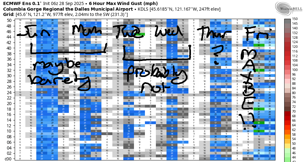
For the rest of us today… a warm front drags some high clouds through, which made for a colorful sunrise, which I almost missed because I woke up at 6:55am! LATE! Temps climb to 79F (west) and 84F from The Dalles eastward. Calm wind this morning rises to 15-20mph this afternoon between Stevenson and Rufus. High clouds stick around all day long. And all night.
Monday’s Gorge weather forecast
This results in a somewhat warmer Monday morning: 50-55F most places. Models are uncertain how much rain we’ll receive tomorrow, but they start it around 2pm as far east as Rowena. Ahead of the rain, the wind picks up to 20mph out of the west between Stevenson and Rufus. Drizzle continues into the evening and extends as far east as Rowena. Highs range from 72F (Hood River) to 77-78F (The Dalles eastward). Clouds stick around all day, but they’ll break up some overnight as that system sweeps through like a road cleaner preparing the roads for the mess that is winter.
Extended Gorge weather forecast
A stronger, wetter, stinkier (MORE PETRICHOR) system is planned for Tuesday evening. During the day, we’ll have a partly cloudy start and increasingly increasing clouds. Rain arrives around 5pm in Cascade Locks, 8pm in The Dalles, and around midnight out in the desert. Tuesday’s wind: calm to start, W 10-15mph in the afternoon. Showers continue Wednesday and keep going into Thursday morning. Many, many rainbows will arise in that 48 hour period. Yay!
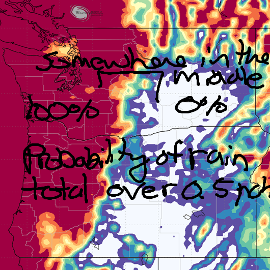
Rain predictions for this entire period – Monday through Thursday – are best expressed in percentiles: nearly 100% chance of 0.1” or more for the entire region; nearly 100% chance of 0.5” or more west of Mosier with 10% chance of 0.5” or more east to Rufus and 0% chance of that much rain east of Rufus. Only the SW WA Cascades have a 100% prediction for 1.0” or more; chances of that much rain are 10-30% between the metro area and The Dalles with a higher chance near Cascade Locks, where model resolution is too low to give us a clear percentage and the vision is obscured by those really, really tall ice cream cones from the East Wind Drive-In.
Let me translate the rain numbers to simple language: we should get a wetting rain everywhere, and we should get a nice soaking for everyone west of The Dalles. Will this end fire season? Hard to say. Depends on what the future holds. Will it give a jump start to foraging season? DEFINITELY! Safe travels. -TATAS
HEY! DON’T STOP READING! Is this community-focused forecast helpful to you? It sure is! It takes me a couple hours a day to write. Please join your friends and neighbors in contributing to keep it going. Venmo: @thegorgeismygym PayPal: twomirrors@gmail.com USPS: Temira / PO Box 841 / Hood River, Oregon 97031 You can test out the forecast subscription for a few days for free by signing up below. Easy! Do it!
MT HOOD SNOW FORECAST

CURRENTLY ON VACATION. WILL RETURN SOMETIME BEFORE THE START OF SKI SEASON AT MEADOWS, TIMBERLINE AND SKIBOWL. SAME GOES FOR THE NORDIC SKIING SEASON AT MEADOWS AND TEACUP!
