

GORGE WIND FORECAST
If you’re still seeing yesterday’s and it’s after 9am, try opening this in an incognito window
today’s gorge wind forecast
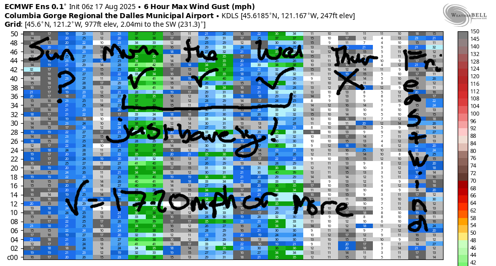
Hi friends! Happy Sunday! Several days of just-enough wind are on tap today through Wednesday. On Thursday and Friday, the Gorge wind forecast has a potential switch to east wind as hot weather sets up on the west side (and here too, but hotter there). Models hint at the cooldown starting late Saturday and really kicking in on Sunday. As of this morning, the GFS thinks next Sunday will be “The Cooldown You Were Looking For”, but the ensembles are not fully on board. We’ll watch this closely! PSA: the Gorge Challenge continues today at the Hood River Waterfront Park. Consider recreating elsewhere!
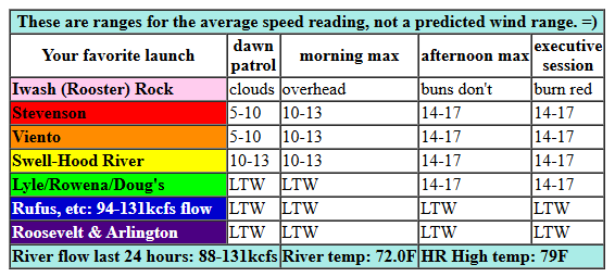
In the meantime… Sunday started off cloudy in the metro area and partly cloudy in the Gorge. Clouds burn off and leave us sunny midday. Early pressures were 30.05/30.03/30.01 for weak onshore gradients. Wind was under 10mph everywhere early in the morning. Light westerlies are on tap through late morning. We then see a slow rise to 14-17mph from Stevenson to Doug’s early afternoon. 17-20mph is likely this evening from Mosier to Avery. It’s possible the Swell-Hood River zone will make that 17-20mph range too, but no promises. River flow over the last 24 hours was 88-131kcfs, river temp is 72.0F (poor salmon), and high temp forecast is 79F.
RIVER FLOW FOR SITES BETWEEN AVERY (EAST OF THE DALLES) AND RUFUS: CLICK HERE FOR JOHN DAY DAM FLOW.
RIVER FLOW FOR SITES BETWEEN STEVENSON AND DOUG’S BEACH (WEST OF THE DALLES): CLICK HERE FOR THE DALLES DAM FLOW

tomorrow’s gorge wind forecast
Monday starts off with a nice marine layer and remnants of other clouds from a weak passing system. Westerlies will be 17-20mph to start from Viento to Swell with 13-16mph from Hood river to Rufus. By late morning, the wind fills in at 17-20mph from Stevenson to Rufus. Afternoon: 15-18mph from Stevenson to Hood River with 19-22mph from Mosier to Rufus. High temp: 77F in Hood River and 82F at Rufus.
extended Gorge wind forecast
Tuesday brings another moderate wind day. Westerlies start at 11-14mph from Viento to Swell. They eventually build to 17-20mph from Stevenson to Mosier with a little more possible late afternoon, perhaps 19-22mph from Mosier to Doug’s. High temp: 82F.
Looking at the extended forecast, we see 19-22mph near Hood River and perhaps Rowena on Wednesday. Thursday brings dawn patrol at 17-20mph or so at the Hatch, but the wind fades to 10mph or less quickly. East wind is forecast on Friday as west side heating outpaces desert heating. Another hot and windless day is forecast Saturday, but if an approaching trough can approach early enough, we’ll see late-day west wind. As of right now, all eyes (at least eyes that like big days) are on the end of this brief hot spell. Models currently have the end on Sunday. That brings the possibility of a big day. Timing of the cooldown often changes from what we see a week out, so I’m keeping a close eye on this. Fortunately, my Sunday and Monday next week are already clear, or clear enough, anyway! Have a great day on the river today!
Was that helpful? I knew it was! Guess what? All of this crucial work – from your personal wind and snow reports to the invaluable TATAS updates – is made possible by my relentless efforts. Maintaining this labor of love isn’t easy. Each daily forecast takes hours. Website hosting, weather model access, and back-end admin work takes time and money. That’s where you come in.
YOUR CONTRIBUTION MAKES A DIFFERENCE
- SUPPORT ACCURATE, HYPER-LOCAL WEATHER FORECASTING
- ENABLE ACCESS FOR ALL, EVEN THOSE WITH LESS MEANS
- SUPPORT A COOL HUMAN WHO WORKS HARD SO YOU CAN PLAY
Take a moment to click one of the buttons below. Donate $19.99 or more (how much does this forecast enhance your life?) and get the email in your inbox. Whether it’s a renewing subscription (auto-renew) or a one-time donation, every contribution makes a real difference. Help me keep this labor of love alive, so we can all continue playing, commuting, and living in the Gorge with peace of mind and the best weather forecasts possible. Thank you!


Hood River, Oregon 97031


JONES BEACH, SAUVIE ISLAND, & COAST FORECAST
Wind northerly unless otherwise indicated. For coast, it’s North/Central/South with the “central” at approximately Florence. Swell forecast from NWS for central coast. Jones: westerly unless otherwise stated. Sauvie Island: northerly unless otherwise stated. Coast Sunday: NW5-10/NW5-10/N5-10, NW swell 6′ at 10 seconds. Monday: LTW/LTNW/LTV, NW 4′ @ 10. Tuesday: NW5-10/NW5-10/NNW10-15, NW 4′ @ 10. Jones Sunday: 11-14. Monday: 11-14. Tuesday: 16-19. Sauvie Island Sunday-Tuesday: 7-10.
BARE BONES HOOD RIVER WEATHER FORECAST
Mostly cloudy this morning. High clouds later. Temps start in the upper 50s and rise to the upper 70s. Light west wind early. Moderate later. No rainbows. Monday will be cloudy then mostly clear. Temps start in the upper 50s and rise to the upper 70s. Moderately westerlies. No rainbows. Tuesday will be mostly clear then partly high overcast. Temps start in the mid 50s and rise to the low 80s. Moderate westerlies. No rainbows.
TEMIRA’S AWESOME TRAVEL ADVISORY SERVICE
HYPERLOCAL WEATHER FORECAST FOR THE COLUMBIA GORGE
THE DALLES, HOOD RIVER, WHITE SALMON, TROUT LAKE, STEVENSON, CASCADE LOCKS, PARKDALE, ODELL, HUSUM, BZ, MILL A, WILLARD, GOLDENDALE, RUFUS, ARLINGTON, boardman

Good morning, neighbors! Pleasantly cool (for summer) weather lingers until Wednesday, and then we’re in for a few days of heat. Max temps will be pushing 90-95 on Thursday, 95-100 on Saturday, and potentially that hot again Sunday in The Dalles and areas to the east. After that: SO. MUCH. UNCERTAINTY! Daily high temp forecast has a 10-15 degree spread starting next Sunday, and that uncertainty lingers all the way through the extended forecast. Next chance of rain: about 30-40% of the ensembles hint at rain in the August 27-30 time frame, but the signal isn’t clear. Don’t count on it.
GLENWOOD THIS MORNING AND TODAY’S GORGE WEATHER FORECAST
For Sunday, you can count on a nice day, at least from my perspective. Glenwood started very chilly this morning: 41 degrees. It would have been colder, but partly cloudy sky interfered with radiational cooling. The rest of us ranged from 49F (upper Parkdale) to 65F (Wishram). Temps climb to the upper 70s (west) and upper 80s (east) this afternoon. Wind will be under 10mph this morning. It builds to 15mph this afternoon between Stevenson and Murdoch with lighter wind to the east. Clouds this morning give way to clear sky midday and high clouds this evening. If there’s a break in those clouds on the west side, we might get lucky with a pretty sunset!
MONDAY, TUESDAY, WEDNESDAY GORGE WEATHER FORECAST
Monday starts with low clouds to the west and partly cloudy sky to the east. Morning temps will be 55-65ish. Afternoon brings 77F (west), 82F (The Dalles) and 89F (watermelon growing zones way out east). Wind will be 15-20mph out of the west between Viento and Hood River early with 20mph between Stevenson and Rufus in the afternoon. On Tuesday, we start mostly clear and finish with a few high clouds. After a 50-something degree start, temps rise to 82/88/91. West wind will be 10-15mph from Viento to Hood River in the morning with 15-20mph from Stevenson to Murdoch in the afternoon. Wednesday looks a lot like Tuesday.
EVEN MORE EXTENDED GORGE WEATHER FORECAST
Warmer, sunny, not-muggy weather is forecast Thursday through Saturday. On Thursday (maybe) and Friday (almost certaintly), we’re likely to see east wind through the Gorge. We care because this results in less-humid conditions and more widespread breezes, even if those breezes aren’t strong. Easterlies can really mess up your spraying program! Saturday also looks hot. Temps (probably) plummet next Sunday. If that really happens, not only will we be cooler, we’ll be blown around all over the place by very strong west wind. Good thing there’s no garbage pickup on Sunday, because the rubbish bins would be going the way of the tumbleweeds: east. Safe travels. -TATAS
HEY! DON’T STOP READING! Is this community-focused forecast helpful to you? It sure is! It takes me a couple hours a day to write. Please join your friends and neighbors in contributing to keep it going. Venmo: @thegorgeismygym PayPal: twomirrors@gmail.com USPS: Temira / PO Box 841 / Hood River, Oregon 97031 You can test out the forecast subscription for a few days for free by signing up below. Easy! Do it!
