

GORGE WIND FORECAST
If you’re still seeing yesterday’s and it’s after 9am, try opening this in an incognito window
today’s gorge wind forecast
Hi friends! We’ve got a couple more windy days on tap, and then we’ll have a break as heat (almost certainly) turns the wind offshore (easterly) or just plain off for a couple of days. Uncertainty exists around when the heat will relent, but we’ll be back to westerlies either Thursday or Friday. Models suggest westerlies will stick around for the long haul after this week’s brief break. Before I forget… if you recently lost a green Slingshot Twintip kiteboard out in the river, shoot me a message. I know who has it, and we’d love to get it back to you!
PSA: we need your help protecting our launch access at the downwind takeouts at the Hatch. The parking area east of the accessible spots is actually Hatchery property, and staff are getting pressure to restrict our access due to vehicles in the roadway. Yesterday someone was taking photos and documenting the situation, so this is becoming urgent. The ask is simple: please keep vehicles out of the road and respond quickly if someone asks you to move. No explanations needed – just a quick “thanks” and relocate your rig. We know parking is tight! If there’s no space, try heading upwind for a downwind run – someone’s always around to shuttle you back. Thanks for helping us keep this amazing spot accessible for everyone. The Hatchery doesn’t have to let us use their land, so let’s make sure they’re glad they do!
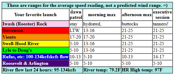
Sunday’s forecast contains wind for you. Early pressures were 30.05/29.99/29.99 for gradients of 0.06 (PDX-DLS) and 0.00 (DLS-PSC). Most locations were under 10mph this morning, and many were under 5mph, but Viento was anomalously high at 23mph. Maybe all the gradient is right there! We’ll see a slow build today as desert heat climbs into the triple digits while the metro area rises to the mid 90s and robust offshore high pressure persists this morning and intensifies this afternoon. By midday, we’ll have 18-21 from Stevenson to Hood River with calm wind out east. Afternoon westerlies rise to 21-25mph between Stevenson and Doug’s with 14-17 at Avery. East of there: under 10mph. Models maintain the wind into the evening and drag it out to Rufus. For the executive session, we’re looking at 21-25 from Stevenson to Rufus with 10-13mph at Arlington. River flow over the last 24 hours was 95-134kcfs (100-134kcfs at Rufus), river temp is 70.2F (the spawning salmon are not happy), and high temp forecast is 97F for Hood River and 100+ for the eastern Gorge.
RIVER FLOW FOR SITES BETWEEN AVERY (EAST OF THE DALLES) AND RUFUS: CLICK HERE FOR JOHN DAY DAM FLOW.
RIVER FLOW FOR SITES BETWEEN STEVENSON AND DOUG’S BEACH (WEST OF THE DALLES): CLICK HERE FOR THE DALLES DAM FLOW

tomorrow’s gorge wind forecast
On to Monday’s forecast: cool air drops down from Canada (thank you, Canada, for continuing to be kind to us!), strong offshore high pressure persists, and the heat low sets up in the desert. Know what this is? Classic Gorge Day! Right off the bat we’ll have 22-25mph from Viento to Mosier. Stevenson: might be cloudy, might not be, which makes it a tough call for dawn patrol there. Midday westerlies rise to 25-28 mph from Viento to Mosier with 20-23mph at Stevenson and 18-22mph between Lyle and Doug’s. Afternoon: 25-28mph from Stevenson to Hood River with 29-33mph from Mosier to Arlington. After 5pm, the wind may drop some, but it’ll still be plenty windy for most. High temp: 84F for Hood River and 91F for Arlington.
extended Gorge wind forecast
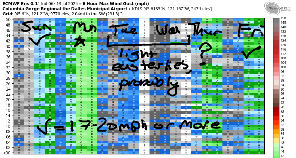
Hot weather spreads across the Pacific Northwest on Tuesday and pretty much shuts down the wind. As of this morning, the Tuesday forecast starts with 10-13mph out of the west for Stevenson-Swell, but the wind turns calm quickly. Midday wind switches direction and picks up to 11-14mph out of the east at Iwash (Rooster) Rock, Stevenson, and Home Valley. Viento is questionable. Easterlies also pick up to 10mph from The Dalles east into the desert. High temp: 90F. Wednesday looks similar to Tuesday: hot with light easterlies. Somewhere in the Thursday-Friday time frame, westerlies will return. There’s no consensus in the models yet on when the wind will return, so I’m going to hold off on making any sort of precise forecast. It does look like we’ll have westerlies through next weekend. Have a great day on the river today!
Was that helpful? I knew it was! Guess what? All of this crucial work – from your personal wind and snow reports to the invaluable TATAS updates – is made possible by my relentless efforts. Maintaining this labor of love isn’t easy. Each daily forecast takes hours. Website hosting, weather model access, and back-end admin work takes time and money. That’s where you come in.
YOUR CONTRIBUTION MAKES A DIFFERENCE
- SUPPORT ACCURATE, HYPER-LOCAL WEATHER FORECASTING
- ENABLE ACCESS FOR ALL, EVEN THOSE WITH LESS MEANS
- SUPPORT A COOL HUMAN WHO WORKS HARD SO YOU CAN PLAY
Take a moment to click one of the buttons below. Donate $19.99 or more (how much does this forecast enhance your life?) and get the email in your inbox. Whether it’s a renewing subscription (auto-renew) or a one-time donation, every contribution makes a real difference. Help me keep this labor of love alive, so we can all continue playing, commuting, and living in the Gorge with peace of mind and the best weather forecasts possible. Thank you!


Hood River, Oregon 97031


JONES BEACH, SAUVIE ISLAND, & COAST FORECAST
Wind northerly unless otherwise indicated. For coast, it’s North/Central/South with the “central” at approximately Florence. Swell forecast from NWS for central coast. Jones: westerly unless otherwise stated. Sauvie Island: northerly unless otherwise stated. Coast Sunday: 20-25/25-30/30-35+, NW swell 7′ at 10 seconds. Monday: 15-20/20-25/35+, NW 7′ @ 9. Tuesday: 15-20/15-20/25-30, NW 7′ @ 9. Jones Sunday: 21-24. Monday: 21-24. Tuesday: 10-13. Sauvie Island Sunday: 18-21. Monday: 13-16. Tuesday: 12-15.
BARE BONES HOOD RIVER WEATHER FORECAST
Mostly clear sky this morning turns clear this afternoon. Temps start in the upper 60s and rise to the upper 90s. Calm wind early. Moderately strong westerlies later. No rainbows. Monday will be mostly clear then clear. Temps start in the upper 60s and rise to the mid 80s. Strong westerlies. No rainbows. Tuesday will be clear then partly cloudy. Temps start in the low 60s and rise to 90. Light westerlies early. Light easterlies (or calm wind) later. No rainbows.
TEMIRA’S AWESOME TRAVEL ADVISORY SERVICE
HYPERLOCAL WEATHER FORECAST FOR THE COLUMBIA GORGE
THE DALLES, HOOD RIVER, WHITE SALMON, TROUT LAKE, STEVENSON, CASCADE LOCKS, PARKDALE, ODELL, HUSUM, BZ, MILL A, WILLARD, GOLDENDALE, RUFUS, ARLINGTON, boardman
Good morning, neighbors! Another hot day is in the cards today (the deck is stacked with hot cards due to climate change), and then we’ll dip down a few degrees on Monday. After that, models have us at 90+ degrees for the extended time period, although there’s quite a bit of range (10+ degrees) in the possible high temps. Know what’s still not in the forecast? Rain.
glenwood this morning
Today, Sunday, will be a hot and muggy one. But before we talk about that, let’s talk about Glenwood: they started the day at 52 degrees, which makes me want to buy a summer home there. It was 69 degrees at my place this morning, and everyone was doing 69 and making gross sexual noises all around me. Up in Glenwood, people were doing 52, which is when you take the dog for a walk and smile at the neighbors knowingly because you’re all enjoying the cool weather together.
today’s gorge weather forecast
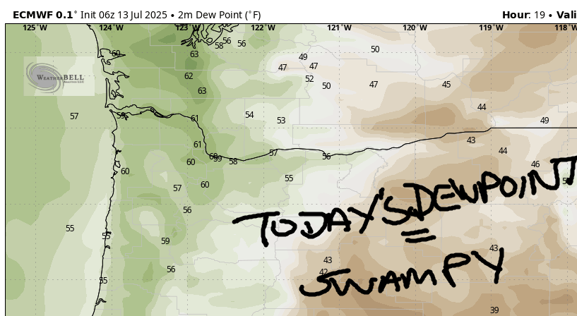
For the rest of today, temps shoot up into the upper 90s (west) and low triple digits (east). Not only will it be hot, it’ll be muggy: the dewpoint holds at 57-59 degrees today, which will feel rather swampy. Thankfully, we’ll have west wind. It slowly builds to 20-25mph this afternoon between Stevenson and Rowena with 15-20mph from The Dalles to Wishram and less wind to the east.
monday’s gorge weather forecast
On Monday, Canada generously sends a cool trough this way. It’s possible those of you west of Hood River will start the day with some low clouds. The rest of us: clear. Temps max out in the mid 80s (west), low 90s (The Dalles) and nearly 100 (watermelon-growing areas out in the desert near Hermiston). West wind will be 20-25mph early from Stevenson to Mosier. It rises to 25-35mph everywhere between Stevenson and Arlington in the afternoon. This, of course, puts us at risk for fast-spreading wildfires. Skip the spark-causing activities (mowing, weed whacking, trailer-chain-dragging, cigarette-butt-tossing) and have an exit plan in mind if you’re in a wildfire-prone zone.
extended gorge weather forecast
On to Tuesday… high temps bounce back into the 90-95 degree range. Wednesday: very similar. Both days will see light east wind, the opposite of what we usually see here in the summer. Heat persists on Thursday and Friday, but the wind turns around and blows out of the west. Starting Thursday, there’s at least 10 degrees of range in the possible daily high temps. If you like me, please do me a favor and vote for the lowest end of that range. My sweat glands have been working overtime this summer so far, as has my washing machine. Both would like a break. Vote early, vote often, vote for the cool side! Safe travels. -TATAS
HEY! DON’T STOP READING! Is this community-focused forecast helpful to you? It sure is! It takes me a couple hours a day to write. Please join your friends and neighbors in contributing to keep it going. Venmo: @thegorgeismygym PayPal: twomirrors@gmail.com USPS: Temira / PO Box 841 / Hood River, Oregon 97031 You can test out the forecast subscription for a few days for free by signing up below. Easy! Do it!
