

GORGE WIND FORECAST
If you’re still seeing yesterday’s and it’s after 9am, try opening this in an incognito window
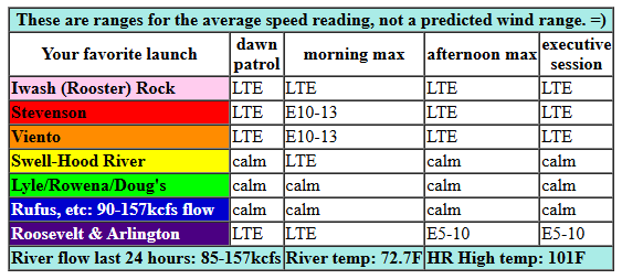
Sunday’s gorge wind forecast
Hi friends! After a couple days of usable easterlies, we’re heading into a day of very light east wind. Models then bring back the westerlies as the hottest temps shift from the west side to The Dalles and then the desert. Models diverge on wind speeds starting Wednesday; the GFS continues to insist on west-side cooling and strong westerlies, but the Euro ensembles are not convinced.
Sunday starts with very light east flow or potentially calm wind. Easterlies pick up to 10-13mph at Stevenson, Home Valley, and Viento for a couple hours mid-morning before dropping below 10mph in the afternoon. Hood River will be calm or nearly so all day as will areas to the east. River flow over the last 24 hours was 85-157kcfs, river temp is 72.7F, and high temp forecast is 101F.
RIVER FLOW FOR SITES BETWEEN AVERY (EAST OF THE DALLES) AND RUFUS: CLICK HERE FOR JOHN DAY DAM FLOW.
RIVER FLOW FOR SITES BETWEEN STEVENSON AND DOUG’S BEACH (WEST OF THE DALLES): CLICK HERE FOR THE DALLES DAM FLOW

monday’s gorge wind forecast
Monday sees onshore flow return as the heat low shifts east of the Cascades. It’s likely we’ll see 10-13mph to start from Viento to Swell. Models knock the wind down mid-morning as heating accelerates. In an interesting twist, model give us 17-20mph in the afternoon from Lyle to Arlington with 11-14mph west between Stevenson and Mosier. I think this is a big maybe, as it depends on a low-probability push of cooler air into the metro area. High temp: 97F in Hood River and 103F near Rufus. That’s some seriously blow-dryer wind if it happens.
extended Gorge wind forecast
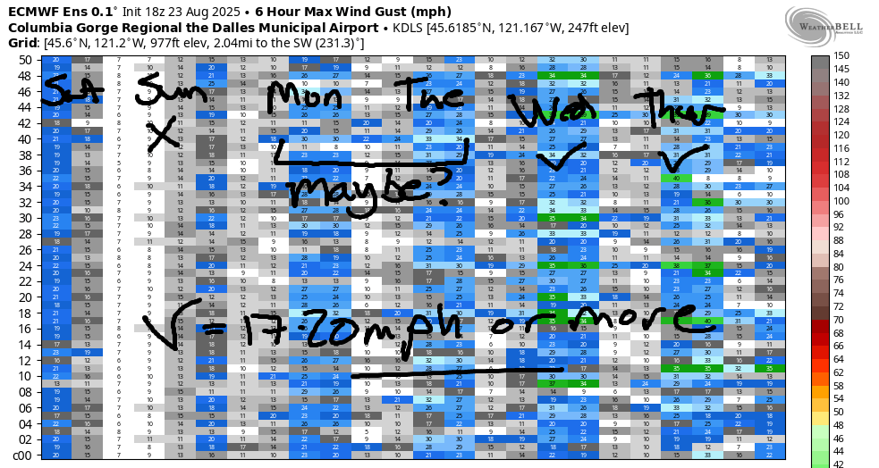
Models seem to agree on slightly stronger wind for Tuesday despite continued very hot weather. As of right now, we’re expecting 13-16mph from Viento to Swell to start with 17-20mph from Stevenson to Hood River late morning. Afternoon: 15-18mph from Stevenson to Doug’s. High temp: 94F for Hood River.
Model agreement collapses on Wednesday when the GFS goes big and the Euro remains unimpressive. No marine clouds are forecast. Temps will be down about 5 degrees all across the region, probably. That’ll help, but something’s going to have to change for the GFS to win this forecast contest. Beyond Wednesday, we see significant uncertainty in the ensembles and also lack of agreement between the models. In a case-in-point example, the high temp spread for Labor day is 20 degrees – 78-98 degrees for The Dalles. No way to forecast with that kind of uncertainty! Anyway, I’ll be gone the 30th through the 4th on a meditation retreat. You’ll have to shred the Nch’i Wana without me and for me!
JONES BEACH, SAUVIE ISLAND, & COAST FORECAST
Wind northerly unless otherwise indicated. For coast, it’s North/Central/South with the “central” at approximately Florence. Swell forecast from NWS for central coast. Jones: westerly unless otherwise stated. Sauvie Island: northerly unless otherwise stated. Coast Sunday: 10-15/10-15/10-15, NW swell 5′ at 7 seconds. Monday: 15-20/20/25-30, NW 5′ @ 8. Tuesday: NNW10-15/10-15/25-30, NW 5′ @ 8. Jones Sunday: 14-17. Monday: 21-24. Tuesday: 24-27. Sauvie Island Sunday: 9-12. Monday: 7-10. Tuesday: 7-10.
BARE BONES HOOD RIVER WEATHER FORECAST
Mostly clear sky Sunday (clouds to the east). Temps start in the low 60s and rise to the low triple digits. Calm wind then light easterlies then calm wind. No rainbows. Monday will be partly to mostly cloudy. Temps start in the mid to upper 60s and rise to the upper 90s (unless the clouds save us). Light westerlies. No rainbows. Tuesday will be partly to mostly cloudy. Temps start in the low 70s and rise to the mid 90s (unless the clouds save us). Moderate westerlies. No rainbows.
TEMIRA’S AWESOME TRAVEL ADVISORY SERVICE – SUNDAY 8/24
HYPERLOCAL WEATHER FORECAST FOR THE COLUMBIA GORGE
THE DALLES, HOOD RIVER, WHITE SALMON, TROUT LAKE, STEVENSON, CASCADE LOCKS, PARKDALE, ODELL, HUSUM, BZ, MILL A, WILLARD, GOLDENDALE, RUFUS, ARLINGTON, boardman
Good evening, neighbors! Wow. It sure was a hot one today! Hood River set a record high-high today, and that’s not the only record that will fall in the next few days. Even The Dalles will be aiming to break some records: Sunday’s record high is 106, and Monday’s is 104. It’s going to be close! When will we cool down? Probably not until the end of the week; the current round of models keeps Hood River at 90+ through Wednesday and The Dalles at 90+ through Thursday. And when will it rain? Well, there’s a very wee chance of thunderstorms this week, but actual rain seems to be quite a ways out unless the models make an abrupt about-face.
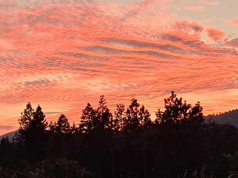
Looking at Sunday, we start plenty warm: 60-70ish depending on location. Record high-low for Hood Rive is 64F. IT’S GONNA BE CLOSE! Temps climb to 101 (Hood River), 105 (The Dalles), and 102 (desert). Hood River’s record is 99F. Given that we’re looking at light wind early, very light east wind midday, and light wind late, that record is almost certain to fall. At the end of the day, some high clouds stream in from the south east of the Cascade Crest and set us up for a pretty sunset. Don’t’ get too excited for the sun to go down and cool things off, because it’s not going to cool off much!
On Monday morning, we start in the mid to upper 60s or warmer if it’s really cloudy, which models think it will be. Afternoon highs range from 97-103, although it could be cooler if those clouds lend a hand. We’ll see light wind until the afternoon when westerlies pick up to 10-15mph from Stevenson to The Dalles with 15-20mph from Avery to Arlington. Tuesday looks hot to start – 70 degrees or so – and hot to finish: 94-100F depending on location. Models hint at a little atmospheric nudge that could potentially kick of thunderstorms on Tuesday (maybe Monday, but less likely). West wind on Tuesday peaks at 15-20mph and fills in between Stevenson and Murdoch.
A slow cooling trend kicks in starting Wednesday, but temps still range form 90-95 degrees. Model agreement really starts to disintegrate towards the end of the week, and there’s 20 degrees of spread in the high temp range for Labor Day. I refuse to attempt to forecast for Labor Day! I’m going to bed now. It’s way too late to be staring at a computer screen, and I’m too tired to be funny. Safe travels. -TATAS
HEY! DON’T STOP READING! Is this community-focused forecast helpful to you? It sure is! It takes me a couple hours a day to write. Please join your friends and neighbors in contributing to keep it going. Venmo: @thegorgeismygym PayPal: twomirrors@gmail.com USPS: Temira / PO Box 841 / Hood River, Oregon 97031 You can test out the forecast subscription for a few days for free by signing up below. Easy! Do it!
MT HOOD SNOW FORECAST

CURRENTLY ON VACATION. WILL RETURN SOMETIME BEFORE THE START OF SKI SEASON AT MEADOWS, TIMBERLINE AND SKIBOWL. SAME GOES FOR THE NORDIC SKIING SEASON AT MEADOWS AND TEACUP!
