

GORGE WIND FORECAST
If you’re still seeing yesterday’s and it’s after 9am, try opening this in an incognito window
today’s gorge wind forecast
Hi friends! Yesterday definitely beat the Gorge wind forecast models as the low clouds stuck around longer than expected. Yay! I was lifting giant pumpkins and moving a giant watermelon, and so I didn’t get to join the fun. Hopefully you did! We’ll have another round of west wind today before we switch into an east wind pattern for Monday and Tuesday. It’s likely we’ll see some sort of west wind on Wednesday (and perhaps beyond) as the weather pattern turns cooler and potentially showery.
Saturday started off with 5am gradients (I have to leave my house by 6:15) of 30.12/30.04/30.01 with clouds on the west side and clear sky to the east. A cold front is approaching and will increase the cloud cover all through the Gorge today. Once again, models are really not in line with what’s happening on the ground in the Gorge. Ah, autumn. You’re a tricky season!
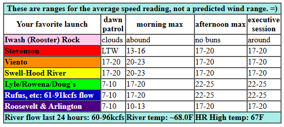
We’ll start with 17-20mph from Viento to Hood River and 12-15mph in the Lyle and Rufus stretches. 20-23mph seems possible this morning from Stevenson to Mosier prior to the clouds increasing. It’s likely that the approaching system will shift the strongest wind to the east this afternoon: gusty 16-19mph from Stevenson to Hood River and gusty 22-25mph from Mosier to Rufus with a touch more possible between Lyle and Rufus. River flow over the last 24 hours was 60-96kcfs, river temp is not updating due to the shutdown (and I don’t have time to look for an alternate source this morning), and high temp forecast is 67F for Hood River and 70F for Rufus.
RIVER FLOW FOR SITES BETWEEN AVERY (EAST OF THE DALLES) AND RUFUS: CLICK HERE FOR JOHN DAY DAM FLOW.
RIVER FLOW FOR SITES BETWEEN STEVENSON AND DOUG’S BEACH (WEST OF THE DALLES): CLICK HERE FOR THE DALLES DAM FLOW

tomorrow’s gorge wind forecast
High pressure builds in hard and fast tonight. This turns the wind offshore. Tomorrow’s max (that’s Sunday if you’ve lost track) will be 15mph near Iwash (Rooster) Rock and 15mph near Stevenson midday. The wind drops below 15mph in the afternoon. High temp: 68F and sunny.
extended Gorge wind forecast
Stronger easterlies are forecast on Monday as a weak heat low spends the morning on the west side and cool air starts the day to the east. Morning wind will be 25mph at Iwash and 20mph from Stevenson to Viento. After 2pm, the wind drops 5pm or so and keeps dropping into the evening. High temp: 69F. Similar conditions are forecast on Tuesday, but the wind will drop off faster and maybe even turn westerly in the evening. Weather: sunny and 72 degrees.
A cold front approaches on Wednesday, but there’s a lot of uncertainty about the details. Generally speaking, the setup looks conducive to some sort of west wind, but it’s probably not The Cooldown You Were Looking For. For the rest of next week, the weather pattern looks active; a series of systems impact the Pacific Northwest. Short periods of west wind are possible with the passage of any given system. You will be breaking out a warmer wetsuit – highs look to be under 70 degrees once this pattern kicks in. Okay. On to the next section. Have a great day on the Nch’i Wana!
Was that helpful? I knew it was! Guess what? All of this crucial work – from your personal wind and snow reports to the invaluable TATAS updates – is made possible by my relentless efforts. Maintaining this labor of love isn’t easy. Each daily forecast takes hours. Website hosting, weather model access, and back-end admin work takes time and money. That’s where you come in.
YOUR CONTRIBUTION MAKES A DIFFERENCE
- SUPPORT ACCURATE, HYPER-LOCAL WEATHER FORECASTING
- ENABLE ACCESS FOR ALL, EVEN THOSE WITH LESS MEANS
- SUPPORT A COOL HUMAN WHO WORKS HARD SO YOU CAN PLAY
Take a moment to click one of the buttons below. Donate $19.99 or more (how much does this forecast enhance your life?) and get the email in your inbox. Whether it’s a renewing subscription (auto-renew) or a one-time donation, every contribution makes a real difference. Help me keep this labor of love alive, so we can all continue playing, commuting, and living in the Gorge with peace of mind and the best weather forecasts possible. Thank you!


Hood River, Oregon 97031


JONES BEACH, SAUVIE ISLAND, & COAST FORECAST
Wind northerly unless otherwise indicated. For coast, it’s North/Central/South with the “central” at approximately Florence. Swell forecast from NWS for central coast. Jones: westerly unless otherwise stated. Sauvie Island: northerly unless otherwise stated. Coast Saturday: 15/10/20-25, W swell 6′ at 10 seconds. Sunday: 20/25/30, NW 5′ @ 11. Monday: 20/20/20-25, W 5′ @ 10. Jones Saturday: 7-10. Sunday/Monday: LTE. Sauvie Island Saturday: 7-10. Sunday: 13-16. Monday: E 10.
BARE BONES HOOD RIVER WEATHER FORECAST
Mostly cloudy today. Temps start in the upper 50s and rise to the upper 60s. Light westerlies early. Moderate later. No rainbows. Sunday will be partly Nothing then sunny. Temp start in the mid 40s and rise to the upper 60s. Light easterlies. No rainbows. Monday will be sunny. Temps start in the low 40s and rise to the upper 60s. Light easterlies. No rainbows.
TEMIRA’S AWESOME TRAVEL ADVISORY SERVICE
HYPERLOCAL WEATHER FORECAST FOR THE COLUMBIA GORGE
THE DALLES, HOOD RIVER, WHITE SALMON, TROUT LAKE, STEVENSON, CASCADE LOCKS, PARKDALE, ODELL, HUSUM, BZ, MILL A, WILLARD, GOLDENDALE, RUFUS, ARLINGTON, boardman
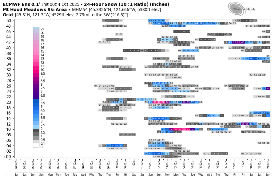
Good morning, neighbors! I gotta keep it quick today – it’s giant pumpkin weigh-off day at Bauman’s, and I got 2 pumpkins and a giant watermelon to get down there. And work to do measuring everyone else’s pumpkins! Generally speaking, we have a cloudy day today, sunshine, east wind, low humidity, and potential for scattered frost Monday, and a wetter, cooler pattern starting Wednesday (probably). In a fun twist (see image), we have our first signs of snow popping up in the (rather useless, but still fun) ECMWF ensemble for Meadows. Snow! Yay!
It’s a bit early still to be calling low temps out (it’s 5:33am), but Glenwood’s sitting at 42F. Hood River is currently 57F at HOXO, one degree above the record high-low for this morning. Warm morning after warm morning… not normal for here, but definitely good for growing giant pumpkins! Cloud cover increases today from west to east. West wind rises to 20-25mph between Stevenson and Rufus. Rain is unlikely. So are rainbows. So is the return of the federal government. Alas.
Sunday sees a pattern switch that’ll last into Tuesday: offshore (easterly) wind, less-humid air, and lots of sunshine. Highs Sunday and Monday will be around 68-70F all throughout the lowlands. A couple degrees more warmth is forecast on Tuesday. Highlights for this period include a chance of frost in Centerville and Glenwood and High Prairie on Sunday morning as 850mb temps drop to 5-6C. Other areas may dip near or below freezing on Monday as the dewpoint falls lower; working against this is widespread east wind at 20mph on Monday, even up in the hills. So… if you’re in an elevate (>1500′) area generally sheltered from east wind (Glenwood), your Tuesday morning may be cold. I’m not sure who else falls into that category (I’ll learn when I look at the temp map Tuesday morning), but be prepared for a possible light frost.
Ma Nature pulls a switcheroo on Wednesday and sends a weather system this way. Temps definitely drop, but it’s unclear how much they’ll drop. It’s also unclear if it’ll rain or not. Not clear: the sky. Clouds are likely. Looking out deeper into the future, we have a decent chance of rain next weekend. For Hood River Harvest Fest. Of course. Thank goodness we’re PNW people and can handle a little drizzle! I’ve just got my fingers crossed that we won’t be doing that naked bike ride protest in cold rain… safe travels. -TATAS
HEY! DON’T STOP READING! Is this community-focused forecast helpful to you? It sure is! It takes me a couple hours a day to write. Please join your friends and neighbors in contributing to keep it going. Venmo: @thegorgeismygym PayPal: twomirrors@gmail.com USPS: Temira / PO Box 841 / Hood River, Oregon 97031 You can test out the forecast subscription for a few days for free by signing up below. Easy! Do it!
MT HOOD SNOW FORECAST

CURRENTLY ON VACATION. WILL RETURN SOMETIME BEFORE THE START OF SKI SEASON AT MEADOWS, TIMBERLINE AND SKIBOWL. SAME GOES FOR THE NORDIC SKIING SEASON AT MEADOWS AND TEACUP!
