

GORGE WIND FORECAST
If you’re still seeing yesterday’s and it’s after 9am, try opening this in an incognito window
today’s gorge wind forecast
Hi friends! West wind is on tap today as a weather system swings through and high pressure builds behind it. That high turns the wind easterly for Monday and Tuesday as a heat low sets up over the Willamette Valley. Models now continue the offshore flow all the way through Wednesday (they previously called for a midday switcheroo, a technical term). Temps (probably) drop on Thursday ahead of a (maybe) cooler system, but uncertainty in the Gorge wind forecast is quite high from Thursday on into the extended forecast. Don’t be writing your calendar in permanent ink yet!
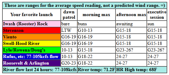
Sunday, as you might have noticed, is starting off a bit differently than recent days. Clouds extend way out east into the desert, and it’s pouring rain west of Cascade Locks. Daybreak wind, naturally, was all over the place, ranging from 3mph in Stevenson to 20-23mph at Viento/Arlington, 10-13mph at the Hatch/Rowena/Rufus. Pressures: 29.9729.89/29.83. /Let this system move through – rain will eventually extend all the way past Arlington, and you’ll want to postpone your action until that’s done.
Afternoon westerlies build to the (gusty) 15-18mph range from Stevenson to Hood River and 24-27mph from Lyle to Arlington. It’s possible the Lyle-Doug’s stretch will be a few mph less… it’s going to be right on the edge. It’s also possible there could be a short period of stronger, gusty west wind in the Corridor as the clouds burn back. Remember that those sensors east of Doug’s read high compared to the Hatch. River flow over the last 24 hours was 77-108kcfs, river temp is 71.2F, and high temp forecast is 68F for Hood River and 74F out in the desert.
RIVER FLOW FOR SITES BETWEEN AVERY (EAST OF THE DALLES) AND RUFUS: CLICK HERE FOR JOHN DAY DAM FLOW.
RIVER FLOW FOR SITES BETWEEN STEVENSON AND DOUG’S BEACH (WEST OF THE DALLES): CLICK HERE FOR THE DALLES DAM FLOW

tomorrow’s gorge wind forecast
High pressure builds inland on Monday for a sunny, east wind day. Early wind will be dead calm – plan some sort of activity that is best in glassy, light-wind conditions! Midday wind rises to E 15mph at Iwash Rock (Rooster), Stevenson, and potentially Viento before dropping back to 10mph everywhere but Iwash in the afternoon. High temp: 75F under clear sky.
extended Gorge wind forecast
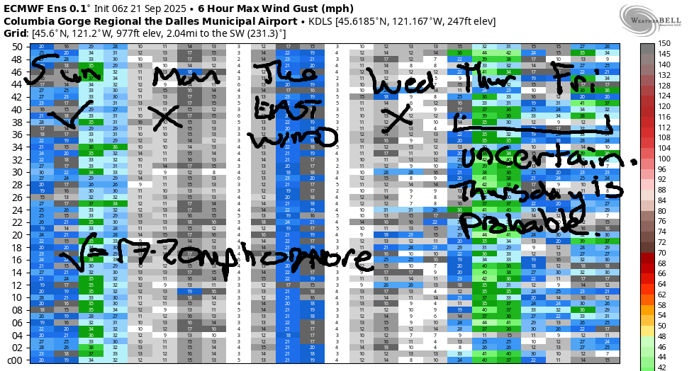
Stronger easterlies are in the cards on Tuesday as a heat low flourishes in the Willamette Valley. The day starts with 20-25mph near Stevenson and 30mph near Iwash Rock. Viento: 20mph. The wind holds for a few hours in the morning and fades in the afternoon. By 2pm, Iwash will be down to 25mph, and Stevenson will fall to 20mph with Viento at 15-20mph. Another 5mph is lost after 2pm, leaving (maybe) just enough east wind for the Executive Session (after 5pm). High temp: 81F and sunny. Easterlies continue at 20mph on Wednesday morning before fading and going calm as some sort of system (probably) approaches the coast. Models have lots of uncertainty beyond Wednesday; it’s likely we’ll see some cooling and the potential for a round of westerlies on Thursday, but the details are far from clear at this point. Beyond that, uncertainty increases, so I”ll leave this here for now. Have a great day today. I’ll see you on the Nch’i Wana!
Was that helpful? I knew it was! Guess what? All of this crucial work – from your personal wind and snow reports to the invaluable TATAS updates – is made possible by my relentless efforts. Maintaining this labor of love isn’t easy. Each daily forecast takes hours. Website hosting, weather model access, and back-end admin work takes time and money. That’s where you come in.
YOUR CONTRIBUTION MAKES A DIFFERENCE
- SUPPORT ACCURATE, HYPER-LOCAL WEATHER FORECASTING
- ENABLE ACCESS FOR ALL, EVEN THOSE WITH LESS MEANS
- SUPPORT A COOL HUMAN WHO WORKS HARD SO YOU CAN PLAY
Take a moment to click one of the buttons below. Donate $19.99 or more (how much does this forecast enhance your life?) and get the email in your inbox. Whether it’s a renewing subscription (auto-renew) or a one-time donation, every contribution makes a real difference. Help me keep this labor of love alive, so we can all continue playing, commuting, and living in the Gorge with peace of mind and the best weather forecasts possible. Thank you!


Hood River, Oregon 97031


JONES BEACH, SAUVIE ISLAND, & COAST FORECAST
Wind northerly unless otherwise indicated. For coast, it’s North/Central/South with the “central” at approximately Florence. Swell forecast from NWS for central coast. Jones: westerly unless otherwise stated. Sauvie Island: northerly unless otherwise stated. Coast Sunday: LTNW/N10-15/N20, W swell 7′ at 11 seconds. Monday: 15-20/20-25/25-30, W 8′ @ 12. Tuesday: 20/15-20/15-20, W 7′ @ 9. Jones Sunday: 7-10. Monday: LTW. Tuesday: LTE. Sauvie Island Sunday: 7-10. Monday: LTN. Tuesday: LTE.
BARE BONES HOOD RIVER WEATHER FORECAST
Cloudy this morning with some drizzle. Partly cloudy this afternoon. Temps start in the low 60s and rise to the upper 60s. Moderate westerlies. 98% chance of rainbows. Monday will be partly Nothing and then sunny. Temps start in the mid 40s and rise to the mid 70s. Calm wind early. Light easterlies later. No rainbows. Tuesday will be sunny. Temps start near 50 and rise to the low 80s. Light easterlies. No rainbows.
TEMIRA’S AWESOME TRAVEL ADVISORY SERVICE – SUNDAY
HYPERLOCAL WEATHER FORECAST FOR THE COLUMBIA GORGE
THE DALLES, HOOD RIVER, WHITE SALMON, TROUT LAKE, STEVENSON, CASCADE LOCKS, PARKDALE, ODELL, HUSUM, BZ, MILL A, WILLARD, GOLDENDALE, RUFUS, ARLINGTON, boardman
Good morning, neighbors! Soothing clouds, a dreamy drizzle, and a breezy afternoon are on tap today. After this, we settle right back into warm, sunny fall weather, although there’s a fair bit of uncertainty about the details starting Thursday. Euro ensemble has a decent chance of rain in the 28-29th time frame, but the GFS’s enthusiasm is more muted.
Glenwood this morning
Looking around the Gorge this morning, we have temps generally in the upper 50s to low 60s. Glenwood started the day at 57F (and muggy), great weather for a jog or a dog walk. Take an umbrella with you – it just started raining at my house in Hood River, and it’s been raining (hard west of Stevenson) for a while in the western Gorge. Back to temps: Hood River was at 59F early this morning, and the record high-low is 58F. Looks like we’re on track for yet another record-setting morning. Warm mornings are the clearest trend of climate change here in the Pacific Northwest.
Today’s Gorge weather forecast
For the rest of today: we’ll have drizzle as far east as The Dalles through 11am and east of The Dalles until early afternoon. Temps max out on the cool side: 68F in Hood River and 74F from The Dalles eastward. After a variable-strength west wind start, westerlies rise to 15-20mph west of Lyle and 25mph from Lyle to Arlington. Clouds burn off (mostly) this afternoon. In between the steady drizzle and the mostly clear sky, we’ll have a period of rainbows. Keep your camera handy! Taking pictures of rainbows is an act of allyship with LGBTQ+ people and an act of resistance against authoritarianism and fascism.*
*You have to following up photo-taking by posting the photos of rainbows on social media and state that you support LGBTQ+ rights. Did you know some (R) representatives are saying we should institutionalize trans people? Saying such things and inciting such talk is violence. It is abhorrent. It is wrong, and it is a sign of a heart contaminated by hatred. It must feel awful to carry such hate and fear in a heart. You, reader, can do better. You can fill your heart with kindness, compassion, and support for people living authentic, joyful lives. You can even have compassion for hearts that are filled with hate – that’s a painful state of existence.
Monday’s Gorge weather forecast
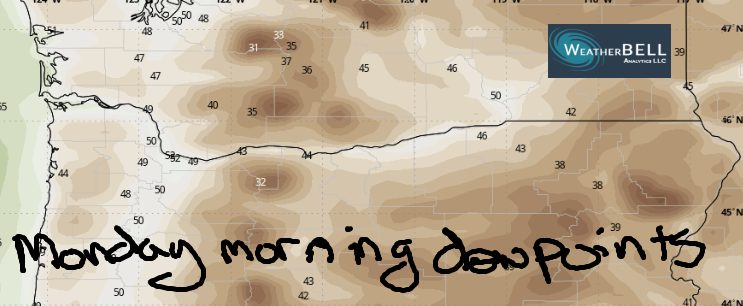
On to Monday: sunny, 75-80 degrees. Calm wind early in the morning gives way to east wind at 15mph between Iwash (johnson) Rock and Viento. To the east of Viento easterlies should be 10mph or less all day. Further details on Monday morning: dewpoints will range from the mid 30s to the mid 40s. With morning temps forecast to drop to the mid 40s along the river (dry air, 850mb temp at 7-8C, low dewpoints, calm wind, and longer nights make this possible), there’s a good chance of a Nothing cloud forming along the river and in some of the valleys away from the river. Also possible: a near-frost morning in Glenwood, or perhaps a foggy morning. Depends on how low the dewpoint will fall.
Extended Gorge weather forecast
Tuesday: warm (80F weest, 86F The Dalles, 81F out east) and sunny. East wind will be 25-30mph between Iwash rock and Viento with E 10-15mph between Viento and the Spring Creek Fish Hatchery and 5-10mph near the mouth of the White Salmon. To the east: less wind. Afternoon wind falls to 20mph in those morning hot spots and stays rather light elsewhere. Wednesday: warm (86-91F), breezy for a bit (morning easterlies at 20mph in the usual windy spots), and calm in the afternoon under clear sky.
Models indicate some sort of pattern change starting Thursday, but there’s a ton of uncertainty in the details from Thursday on. Models do agree on a near-zero chance of rain until the first couple days of next week, when rain is possible but far from certain. In a fun twist, the operational GFS is an outlier with 850mb temps falling to 0C early next week, which translates to a snow level of around 5000′. This has a near-zero chance of actually coming to fruition, but it’s fun to see. Just to be clear: no need to install your snow tires. Yet. Safe travels. -TATAS
HEY! DON’T STOP READING! Is this community-focused forecast helpful to you? It sure is! It takes me a couple hours a day to write. Please join your friends and neighbors in contributing to keep it going. Venmo: @thegorgeismygym PayPal: twomirrors@gmail.com USPS: Temira / PO Box 841 / Hood River, Oregon 97031 You can test out the forecast subscription for a few days for free by signing up below. Easy! Do it!
MT HOOD SNOW FORECAST

CURRENTLY ON VACATION. WILL RETURN SOMETIME BEFORE THE START OF SKI SEASON AT MEADOWS, TIMBERLINE AND SKIBOWL. SAME GOES FOR THE NORDIC SKIING SEASON AT MEADOWS AND TEACUP!
