

GORGE WIND FORECAST

today’s gorge wind forecast
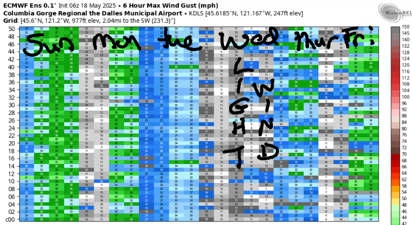
Hi friends! Westerlies continue most days this week with enough wind somewhere to get many, but not all of you on the water. Next rest day in the Gorge wind forecast is Wednesday, when ensembles keep the wind quite light. Today is probably going to be the windiest day of the next five, and beyond that, model uncertainty really leave us forecasters with no words and a simple shrug. Do keep an eye on the early part of the week that starts with Memorial Day. There’s some possibility for a warmup-cooldown scenario that could fire off a bigger day. Zero sure sign of that yet, but there’s at least a little chance!
So, let’s look at Sunday: we’ve got an approaching front offshore and a weak low headed to the east side. Early pressures were 30.15/30.07/29.99 for gradients of 0.08/0.08. Aloft, wind starts at NW 30 and drops to NW 25 (generally a good sign for Rufus). We also have a shot at instability east of Arlington this afternoon and showers to Hood River this morning. That’s a lot of moving pieces, but we will have wind. Westerlies started the day with gusty 10-20 west of Mosier, 15-20 near Rowena, 30mph near Rufus, and low 20s at Arlington. Peak wind will be late morning to mid-afternoon today, fading after 5pm. We’ll have gusty 13-16 from Stevenson to Hood River (maybe to Mosier – it could climb to the mid 20s) with 28-32 from Avery to Threemile and 23-26 near Boardman. The Lyle-Doug’s stretch is going to be right on the edge, but could easily join with 28-32, and could easily stay lighter if clouds persist. After 2pm, the wind drops to 7-10 west of Avery and drops to 22-25 from Avery to Boardman. River flow over the last 24 hours was 199-247kcfs (204-247kcfs at Rufus), river temp is 56.5F, and high temp forecast is 61F in the west and 62F out east.

tomorrow’s gorge wind forecast
Monday starts with “light” wind, under 10mph all through the Gorge. Westerlies slowly, ever so slowly, build. By late morning, we’ll have 7-10mph from Stevenson to Doug’s and 14-17 from Avery to Arlington. Drizzle is likely as far east as Threemile into late morning or early afternoon. Once it’s done, the wind rises to gusty 14-17 from Stevenson to Doug’s with 23-26 from Avery to Boardman. Areas east of Avery hold into the evening, but areas west of Avery will drop below 10mph. High temp: 62F on the west side and 65F on the east side.
extended Gorge wind forecast
Tuesday also looks windy. The day kicks off with less than 10mph west of The Dalles and 13-16 east of The Dalles. We’ll see a slow build to 15-18mph west of Lyle. After noon or so, Lyle-Threemile rises to 22-25 and holds into the evening. High temp: 64-65F.
Wednesday looks like the rest day you’ve been waiting for: models currently have us light/variable all day long. Westerlies are likely to return on Thursday and continue, but there’s also quite a bit of uncertainty in the models. If you’d like the best-case Memorial Day scenario, vote for a weekend warm-up followed by a dramatic cooldown on Memorial Day – at least a few members of the ensembles like that idea as does the operational GFS. This is by no means a majority opinion, but it’s the outcome I’d like to see – nuking wind. But then again, that’s almost always my preferred outcome – I definitely have a strong wind bias. Have a great day on the Nch’i Wana, everyone!
Was that helpful? I knew it was! Guess what? All of this crucial work – from your personal wind and snow reports to the invaluable TATAS updates – is made possible by my relentless efforts. Maintaining this labor of love isn’t easy. Each daily forecast takes hours. Website hosting, weather model access, and back-end admin work takes time and money. That’s where you come in.
YOUR CONTRIBUTION MAKES A DIFFERENCE
- SUPPORT ACCURATE, HYPER-LOCAL WEATHER FORECASTING
- ENABLE ACCESS FOR ALL, EVEN THOSE WITH LESS MEANS
- SUPPORT A COOL HUMAN WHO WORKS HARD SO YOU CAN PLAY
Take a moment to click one of the buttons below. Donate $19.99 or more (how much does this forecast enhance your life?) and get the email in your inbox. Whether it’s a renewing subscription (auto-renew) or a one-time donation, every contribution makes a real difference. Help me keep this labor of love alive, so we can all continue playing, commuting, and living in the Gorge with peace of mind and the best weather forecasts possible. Thank you!


Hood River, Oregon 97031


JONES BEACH, SAUVIE ISLAND, & COAST FORECAST
Wind northerly unless otherwise indicated. For coast, it’s North/Central/South with the “central” at approximately Florence. Swell forecast from NWS for central coast. Jones: westerly unless otherwise stated. Sauvie Island: northerly unless otherwise stated. Sunday: W5-10/W5-10/NNW10-15, W swell 6′ at 9 seconds. Monday: W15/W10/LTV, W 6′ @ 10. Tuesday: LTNW/LTNW/N25+, W 10′ @ 13. Jones Sunday: LTW. Monday: LTW. Tuesday: 7-10. Sauvie Island Sunday: W 10-13. Monday: variable to 10. Tuesday: LTV.
BARE BONES HOOD RIVER WEATHER FORECAST
Clouds and drizzle until mid-morning then partly cloudy. Temps start in the upper 40s and rise to the low 60s. Light westerlies. 99% chance of rainbows. Monday will be cloudy with drizzle into early afternoon then mostly clear. Temps start in the mid 40s and rise to the low 60s. Light westerlies early. Moderate later. 99% chance of rainbows. Tuesday will be cloudy with drizzle early and partly cloudy in the afternoon. Temps start in the mid 40s and rise to the mid 60s. Light west wind early. Moderate later. 99% chance of rainbows.
TEMIRA’S AWESOME TRAVEL ADVISORY SERVICE – SUNDAY 5/18
HYPERLOCAL WEATHER FORECAST FOR THE COLUMBIA GORGE
THE DALLES, HOOD RIVER, WHITE SALMON, TROUT LAKE, STEVENSON, CASCADE LOCKS, PARKDALE, ODELL, HUSUM, BZ, MILL A, WILLARD, GOLDENDALE, RUFUS, ARLINGTON, boardman
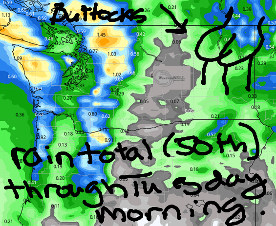
Good morning, neighbors! Cool, intermittently drizzly weather is in the cards for the next few days. Bad weather for tanning your buttocks. Good weather for lots of other things. After midweek, models are all over the place on the ridging (warm)/troughing (cool) options. Memorial Day remains my favorite of the next two weeks with a 20 degree spread on possible temps. Warmest day of the next 10 is likely to be the Sunday of Memorial Day weekend. Plan to BBQ then and please make ribs to share with me. Pork ribs. Just being clear.
Before we dive in, let’s dive in to Glenwood’s Sunday morning stats like someone who loves muff diving in to a muff first thing in the morning: it’s 45F there (Glenwood, not my muff) as I type this, and the overnight low was 42F. Nothing to write home about there! Nobody at home wants to hear about your morning muff-dive in Glenwood!
Glenwood’s morning and today’s gorge weather forecast
Today (it’s Sunday) brings a bit of intermittent drizzle as far east as Hood River into late morning. I’ve seen plenty of drizzle so far, but I haven’t yet seen a rainbow. But I’ve been staring at a computer screen and may have missed a rainbows. Even so, let’s call it a 99% chance of rainbows today. By noon, clouds start to break up, and we’re left with partly cloudy (mid-level clouds, if you care about the deets) sky all the way into the desert. Westerlies rise to 10-15mph west of Lyle and 25-35mph from Lyle to Threemile. After 5pm or so, the wind starts to fade, but remains breezy into the evening. Highs will be in the low 60s everywhere in the lowlands today. Wind Johnnys will be out east zipping around on the river and eating Indian food at Amayah’s, the location formerly known as Biggs.
mONDAY’S GORGE WEATHER FORECAST
Another round of drizzle is forecast on Monday morning, and this one should be more extensive: models take at least a little rain all the way east past the Tri-Cities. Rain ends for all areas except the far western Gorge by 2pm. Accompanying the drizzle: wind, of course. Westerlies start light west of The Dalles with 15mph east of The Dalles. Afternoon wind builds to 15-20mph west of Lyle and 20-30mph from Lyle to Arlington. High temps: low 60s in the west and mid 60s to the east.
TUESDAY’S GORGE WEATHER FORECAST & THE EXTENDED FORECAST
Tuesday looks cloudy in the morning and partly cloudy in the east. Wind and temps will be similar to Monday. Moving on to Wednesday: a few degrees warmer, mostly sunny, and not windy at all. Thursday: a few more degrees of warmth, a moderate westerly breeze, and at least some sun. After Thursday, model agreement declines. Euro ensembles are bullish about Sunday being a warm day despite at least 10 degrees of model spread. That makes Sunday a good possibility for 1) barbecuing and 2) tanning your buttocks at Iwash Rock. Beyond that, predictability really declines as model spread widens. That’s what you get for having a Monday holiday. Uncertainty. Safe travels. -TATAS
HEY! DON’T STOP READING! Is this community-focused forecast helpful to you? It sure is! It takes me a couple hours a day to write. Please join your friends and neighbors in contributing to keep it going. Venmo: @thegorgeismygym PayPal: twomirrors@gmail.com USPS: Temira / PO Box 841 / Hood River, Oregon 97031 You can test out the forecast subscription for a few days for free by signing up below. Easy! Do it!

One response to “Sunday Gorge wind forecast: breezy every day except Wednesday. Cool with a chance of showers for the Gorge.”
Thank you.