

GORGE WIND FORECAST
If you’re still seeing yesterday’s and it’s after 9am, try opening this in an incognito window
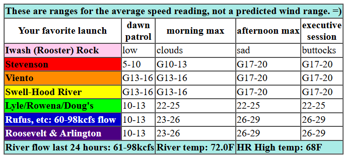
today’s gorge wind forecast
Hi friends! Hello again from Cloud Mountain Retreat Center, where I’m helping with a retreat. It’s cloudy here, but it’s not raining. Out in the Gorge: lots of clouds today, maybe a little drizzle, and a solid afternoon of west wind. Wind speeds drop way off for Monday as high pressure builds inland and eventually turns the flow offshore. Easterlies are in the cards for Tuesday, and they should be plenty strong to get many of you on the river. Models are pretty consistent in calling for a windy Corridor day on Wednesday as cool air approaches the coast. After that: increasing uncertainty in the Gorge wind forecast and not much chance of getting a reliable forecast (or writing one) at this point.
Let’s look at Sunday: a cold front is moving through with lots of clouds and just a little drizzle. Early gradients were 2987/29.81/29.82, and wind speeds were 10mph or less everywhere except Viento-Hatch. That zone was reading 14-17mph to start the day. Not much happens this morning while the weather system is lingering. We’ll see drizzle as far east as The Dalles until early afternoon with drizzle east of Arlington into the evening.
Starting late morning or early afternoon, westerlies build. Models suggest the low clouds will burn back. That gives us gusty 17-20mph from Stevenson to Mosier with 22-25 from Lyle to Rufus and 24-27 form Philippi Canyon to Boardman. For the afternoon, offshore high pressure builds and a weak low develops in the desert. This nudges the wind upwards to 26-29mph from Maryhill to Boardman. Remember that those eastern Gorge sensors read high compared to Swell; 26-29mph out east is approximately equivalent to 19-22mph at Swell. River flow over the last 24 hours was 60-98kcfs, river temp is 72.0F (poor salmon!), and high temp forecasts are 68F in Hood River and 75F at Rufus and Arlington.
RIVER FLOW FOR SITES BETWEEN AVERY (EAST OF THE DALLES) AND RUFUS: CLICK HERE FOR JOHN DAY DAM FLOW.
RIVER FLOW FOR SITES BETWEEN STEVENSON AND DOUG’S BEACH (WEST OF THE DALLES): CLICK HERE FOR THE DALLES DAM FLOW

tomorrow’s gorge wind forecast
High pressure builds inland on Monday. The day starts with west wind at 10-13mph or a touch more from Viento to the Hatch. This doesn’t last. Models turn the wind lightly offshore (maybe 10mph between Rooster and Viento) in the afternoon as temps equalize across the region. High temp: 76F.
extended Gorge wind forecast
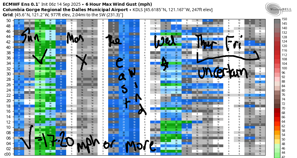
On Tuesday, a heat low sets up west of the Cascades and high pressure settle in east of the Cascades. A more robust day of east wind is on tap. For several hours in the morning, we’ll have this: Rooster Rock (Iwash Rock) at 25-30mph, Stevenson at 20-25mph, Viento at 20mph. After noon or so, the wind begins to drop. Early afternoon easterlies will be 20mph at Iwash Rock, 20mph at Stevenson, and 15mph at Viento. The wind falls another 5mph as evening approaches. High temp: 82F.
A cool trough and associated cold front are forecast to approach on Wednesday. High pressure builds in behind this action. All signs point to the Corridor; looking at the Euro ensembles, there’s not much to see, but that’s because the wind will probably be focused west of that data point. While the wind has been trending slightly downward, models still (please let this hold!) have us with 25-28mph from Stevenson to Doug’s, strongest in the afternoon. Model agreement falls apart beyond Wednesday; the general pictures has cooler temps and some sort of troughing offshore, but the timing and intensity of the bits and pieces is uncertain as of now. So I’ll leave it there. Have a great day on the Nch’i Wana!
