

GORGE WIND FORECAST
If you’re still seeing yesterday’s and it’s after 9am, try opening this in an incognito window
today’s gorge wind forecast
Hi friends! Ma Nature took her time last night. Too much time. She finally turned on the eastern Gorge wind machine (37mph at Threemile) around 8pm. Viento joined the after-dark fun too with 40mph. Stevenson was really the only place that fired up in the daylight hours: it was reading 30mph when I looked late afternoon. Our next chance for wind is this afternoon. A break is forecast Monday. Easterlies look strong enough to get you on the river on Tuesday. Wednesday: westerlies. Thursday: easterlies… beyond that… wet, probably! Before I forget: if you need something to do today, HRATS has a trail work party in Post Canyon. Meet at Family Man at 9am.
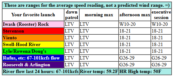
Today starts calmish with light offshore gradients. Easterlies build to 10-15mph for a couple hours at Stevenson before dying off and turning westerly as today’s weather system makes a move. We should see gusty 18-21mh from Stevenson to Mosier with 26-29mph from Avery to Rufus this afternoon as a low moves into the desert. For the Lyle-Doug’s stretch, things are questionable, but probably gusty low to mid 20s. After 5pm, the 28-31mph wind spreads all the way east to Threemile and Plymouth with 23-26mph at Boardman. Best chance for wind will be after 2pm, after the rain starts, moves through, and then stops. River flow over the last 24 hours was 67-101kcfs, river temp is 59.2F, and high temp forecast is 50F for Hood River and 55F for the desert.
RIVER FLOW FOR SITES BETWEEN AVERY (EAST OF THE DALLES) AND RUFUS: CLICK HERE FOR JOHN DAY DAM FLOW.
RIVER FLOW FOR SITES BETWEEN STEVENSON AND DOUG’S BEACH (WEST OF THE DALLES): CLICK HERE FOR THE DALLES DAM FLOW

tomorrow’s gorge wind forecast
A ridge builds on Monday. Lingering 10-13mph westerlies are possible early in the morning. Afternoon sees the wind go calm and maybe even turn easterly. High temp: 54F for Hood River with low clouds and sprinkles in the morning and partly cloudy sky later.
extended Gorge wind forecast
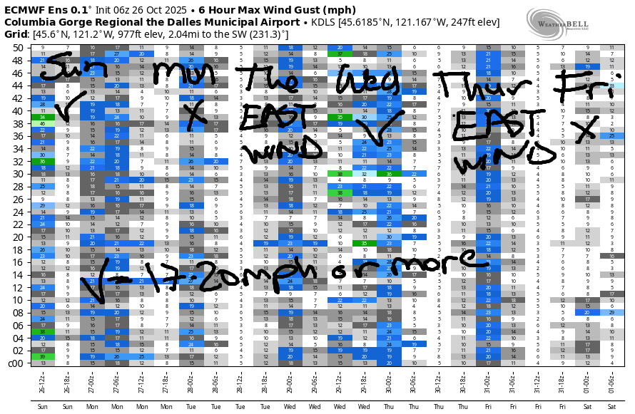
On Tuesday, cool air and high pressure on the east side combines with warmer air on the west side for offshore wind. As of Sunday morning, models started the Tuesday with 40mph at Iwash (Rooster) Rock and 30mph at Stevenson. As usual, the wind will fade some in the afternoon. Stevenson finishes up with 20-25mph, and Iwash finishes up with 25-30mph. Looks like a solid day to get on the river! High temp: 54F for Hood River with a cloudy start and high clouds later. Next chance for westerlies is on Wednesday morning, but ensembles aren’t all in at this point. For now, we have a forecast of dry weather and easterlies at 30mph on Thursday. Friday on: potentially quite wet! That’s enough for now. See you on the Nch’i Wana!
Was that helpful? I knew it was! Guess what? All of this crucial work – from your personal wind and snow reports to the invaluable TATAS updates – is made possible by my relentless efforts. Maintaining this labor of love isn’t easy. Each daily forecast takes hours. Website hosting, weather model access, and back-end admin work takes time and money. That’s where you come in.
YOUR CONTRIBUTION MAKES A DIFFERENCE
- SUPPORT ACCURATE, HYPER-LOCAL WEATHER FORECASTING
- ENABLE ACCESS FOR ALL, EVEN THOSE WITH LESS MEANS
- SUPPORT A COOL HUMAN WHO WORKS HARD SO YOU CAN PLAY
Take a moment to click one of the buttons below. Donate $19.99 or more (how much does this forecast enhance your life?) and get the email in your inbox. Whether it’s a renewing subscription (auto-renew) or a one-time donation, every contribution makes a real difference. Help me keep this labor of love alive, so we can all continue playing, commuting, and living in the Gorge with peace of mind and the best weather forecasts possible. Thank you!


Hood River, Oregon 97031


MT HOOD SNOW FORECAST

Hey skiers and snowboarders! The slopes picked up a good layer of snow last night, but not as much as we’d hoped: 9” for Timberline and 6-7” for Meadows. Sometimes the Mt Hood snow forecast models get overexcited this time of year. Like me! Teacup webcam just shows a trace, but they’re saying they’ll snowmobile groom if they get enough by tomorrow. If you want to play in the snow, get it soon, and definitely get it by this week, because a warm atmospheric river (Pineapple Express) is possible late next week.
Sunday morning started cloudy on Mt. Hood. More snow is coming! The snow level is 3500′ this morning, 3000′ this afternoon, and 2500′ at the tail end of this system tonight. About 0.4” water equivalent (WE) is forecast today for about 4” of new. Overnight: 0.2” to 0.3” WE for 2-3” more. Wind: SW 15-20 this morning, WNW 25-30 this afternoon, and W 20 after midnight.
Monday starts with snow and turns partly high overcast. The snow level will be 2500′ early, 3500′ in the afternoon, and the freezing level will rise to 10,000′ overnight. Just an inch of new snow is forecast early in the morning before the weather turns dry. Wind: W 20 in the morning and light southerly in the afternoon and overnight. Dry, warmer weather is forecast on Tuesday as the freezing level rises to 10,000′ or higher. Wind: S 5-15 during the day turning to NW 20 after midnight as the next system approaches. We could pick up an inch of snow early Wednesday with the passage of a cold front, but the weather quickly turns warm after that.
For the longer-range forecast, models are vacillating about a warm/wet system next weekend. It’s unclear as of now whether the bulk of the rain will stay to the north or whether it will slam directly into Mt. Hood. Let’s not get too hung up on the details – it’s still very early in the season! Have an awesome day today, especially if you’re playing in the snow!
BARE BONES HOOD RIVER WEATHER FORECAST
Clouds this morning and partly high overcast later. Rain midday. Temps start in the low 40s and rise to 50. Calm wind in the morning. Moderate westerlies later. 97% chance of rainbows. Monday starts cloudy and turns partly high overcast. Temps start in the upper 30s and rise to the mid 50s. Sprinkles are possible in the morning. Light westerlies for the first half of the day. Calm later. 98% chance of rainbows. Tuesday will be partly cloudy then high overcast. Dry until after midnight. Temps start in the upper 30s and rise to the mid 50s. Easterlies. No rainbows.
TEMIRA’S AWESOME TRAVEL ADVISORY SERVICE
HYPERLOCAL WEATHER FORECAST FOR THE COLUMBIA GORGE
THE DALLES, HOOD RIVER, WHITE SALMON, TROUT LAKE, STEVENSON, CASCADE LOCKS, PARKDALE, ODELL, HUSUM, BZ, MILL A, WILLARD, GOLDENDALE, RUFUS, ARLINGTON, boardman

Good morning, neighbors! Finally, finally, after months of dry and repetitive forecasts, we’ve got STUFF to talk about! Lowland rain, mountain snow, atmospheric rivers…
Glenwood this morning
Up in Glenwood this morning, it’s 38 degrees, not much cooler than Hood River, which is 42 degrees, the answer to life, the universe, and everything. I knew there was a good reason I moved here! At Meadows, it’s 28 degrees, and at Teacup, it’s 31 degrees. West of the Cascade Crest this morning, moisture is pouring down as an atmospheric river massages the sky and causes it to ejaculate rain down low and snow above 3500′.
Today’s Gorge weather forecast
Here in the lowlands, we’ll have a cloudy start with rain eventually moving all the way east to the Tri-Cities. Behind the rain, skies clear to the east of the crest and finish partly high overcast to the west. Rain intensity will be moderate as this system swings through, which is enough for hydroplaning. Be careful out there! Temps max out around 50F to the west and 55F from The Dalles eastward. West wind rises to 15-20mph west of The Dalles and 25-35mph east of The Dalles, strong enough to coax even the wettest of tumbleweeds into tumbling. Snow level: 3500′. Passes: increasingly snowy as the day goes on: 4-7” is forecast.
Monday-Tuesday Gorge weather forecast
On Monday morning, showers extend as far east as Hood River. Be cautious: rainbows will be plentiful and may cause spontaneous feelings of graitude and joy. Monday afternoon: dry with a few high clouds to the west and sunshine to the east. Wind: light west early and calm later. Temps: right around 40F in the morning and 54-57F in the afternoon. Tuesday: also dry with a mix of clouds in the morning and a shield of high clouds sliding in from the west in the afternoon. After a mid-30s start, temps rise to 54F (Hood River), 57F (The Dalles), and 53F (way out east). We’ll have east wind on Tuesday: 40mph near Iwash and 30mph near Stevenson with 5-10mph east of Underwood.
Extended Gorge weather forecast
Next up: a round of light rain early Wednesday morning followed by dry weather Wednesday afternoon, Thursday, and then also Friday morning. Models have not coalesced around a solution for Halloween and next weekend, but there’s at least a 50% chance of a moderate to strong atmospheric river pounding us with warm(ish) rain starting Friday afternoon. We’ll keep a close eye on that as the rain could be heavy enough to F with the commute through the Gorge. Costume recommendation: inflatable frog costumes work well as raingear… Snow levels look to remain high next weekend, high enough to spare the passes from another round of snow. Sad. I’m ready for snow and ski season, or at least for the volcanoes to be completely blanketed in deep snow and shining brightly whenever the clouds retreat. Safe travels. -TATAS
HEY! DON’T STOP READING! Is this community-focused forecast helpful to you? It sure is! It takes me a couple hours a day to write. Please join your friends and neighbors in contributing to keep it going. Venmo: @thegorgeismygym PayPal: twomirrors@gmail.com USPS: Temira / PO Box 841 / Hood River, Oregon 97031 You can test out the forecast subscription for a few days for free by signing up below. Easy! Do it!
JONES BEACH, SAUVIE ISLAND, & COAST FORECAST
ON WINTER VACATION!!!
