

GORGE WIND FORECAST
If you’re still seeing yesterday’s and it’s after 9am, try opening this in an incognito window
today’s gorge wind forecast
Hi friends! Spectacular fall weather arrives for the next few days, and that means we’ll be awash in easterlies. Not super strong easterlies, but easterlies. Wednesday’s Gorge wind forecast calls for a round of westerlies, but models are quite uncertain as to how strong they’ll be. Probably strong enough. Beyond that, uncertainty increases, and so does the chance of much cooler, wetter weather.
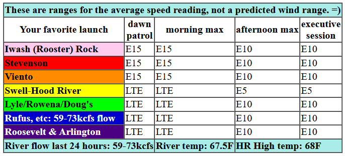
Looking at Sunday, we start with light easterlies and flat gradients: 30.12/30.12. East wind rises to 15mph or so at Iwash (Rooster) Rock and 10mph at Stevenson. The wind holds into midday, and then levels out at 10mph at all the usual east wind spots. East of the Hatch, afternoon easterlies rise to 5-10mph. River flow over the last 24 hours was 59-73kcfs, river temp is 67.5F, and high temp forecast is 68F with full-on sunshine.
RIVER FLOW FOR SITES BETWEEN AVERY (EAST OF THE DALLES) AND RUFUS: CLICK HERE FOR JOHN DAY DAM FLOW.
RIVER FLOW FOR SITES BETWEEN STEVENSON AND DOUG’S BEACH (WEST OF THE DALLES): CLICK HERE FOR THE DALLES DAM FLOW

tomorrow’s gorge wind forecast
Stronger easterlies are forecast on Monday. The day starts with 30mph near Iwash and 20-25mph near Stevenson with 20mph near Home Valley and Viento. The wind holds until late morning and then starts to fade. Afternoon westerlies drop to 15-20mph near Iwash, 15mph near Stevenson, and rise to 10mph east of the Hatchery. High temp: 70F. Morning low: 40F. Sky: sunny. A similar start is forecast on Tuesday, but the wind will drop off faster and more completely. By late afternoon, wind speeds will be below 10mph all through the Gorge. High temp: 72F after a morning low of 42F.
extended Gorge wind forecast
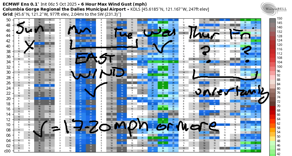
Looking at Wednesday, we see a system approaching the coast. To the west of it: high pressure. In the desert: some sort of warmth. About 80% of the Euro ensembles members give us 17-20mph or more, and about 45% of them give us 22-25mph or more. GFS deterministic: 20mph. Not much is forecast on Thursday or Friday. Looking at next weekend, we have very active weather (rain as far east as The Dalles) with relatively strong (and cold) upper-level wind. Generally speaking, this is a good setup for the eastern Gorge – Maryhill eastward. We’ll keep a close eye on this! Until then… I’ll see you on the Nch’i Wana!
Was that helpful? I knew it was! Guess what? All of this crucial work – from your personal wind and snow reports to the invaluable TATAS updates – is made possible by my relentless efforts. Maintaining this labor of love isn’t easy. Each daily forecast takes hours. Website hosting, weather model access, and back-end admin work takes time and money. That’s where you come in.
YOUR CONTRIBUTION MAKES A DIFFERENCE
- SUPPORT ACCURATE, HYPER-LOCAL WEATHER FORECASTING
- ENABLE ACCESS FOR ALL, EVEN THOSE WITH LESS MEANS
- SUPPORT A COOL HUMAN WHO WORKS HARD SO YOU CAN PLAY
Take a moment to click one of the buttons below. Donate $19.99 or more (how much does this forecast enhance your life?) and get the email in your inbox. Whether it’s a renewing subscription (auto-renew) or a one-time donation, every contribution makes a real difference. Help me keep this labor of love alive, so we can all continue playing, commuting, and living in the Gorge with peace of mind and the best weather forecasts possible. Thank you!


Hood River, Oregon 97031


JONES BEACH, SAUVIE ISLAND, & COAST FORECAST
Wind northerly unless otherwise indicated. For coast, it’s North/Central/South with the “central” at approximately Florence. Swell forecast from NWS for central coast. Jones: westerly unless otherwise stated. Sauvie Island: northerly unless otherwise stated. Coast Sunday: 15-20/25/30, NW swell 5′ at 11 seconds. Monday: 20/20/20-25, NW 5′ @ 8. Tuesday: 20/15/10-15, NW 5′ @ 8. Jones Sunday: LTV. Monday: LTE. Tuesday: 17-20. Sauvie Island Sunday: 10-13. Monday: E 10. Tuesday: LTV.
BARE BONES HOOD RIVER WEATHER FORECAST
Clear sky all day Sunday. Temps start in the low 40s and rise to the upper 60s. Light easterlies. No rainbows. Monday will be sunny. Temps start near 40 and rise to 70 or so. Light easterlies. No rainbows. Tuesday will be sunny. Temps start in the low 40s and rise to the low 70s. Light easterlies. No rainbows.
TEMIRA’S AWESOME TRAVEL ADVISORY SERVICE
HYPERLOCAL WEATHER FORECAST FOR THE COLUMBIA GORGE
THE DALLES, HOOD RIVER, WHITE SALMON, TROUT LAKE, STEVENSON, CASCADE LOCKS, PARKDALE, ODELL, HUSUM, BZ, MILL A, WILLARD, GOLDENDALE, RUFUS, ARLINGTON, boardman
Good morning, neighbors! Fall doesn’t get any more autumn-like than the next three days in the Gorge: sunshine, cool mornings, 70 degree afternoons. But as we know, fall will eventually fall into winter. Our first taste of cold rain looks to arrive next weekend – models are insistent on this in a way they haven’t been yet. Fingers crossed – we need rain!
Glenwood this morning
Checking in with our friends in Glenwood this morning, we’ve got… FROST! Low temp there was 31 degrees. Looks like everyone else is above freezing this morning; next closest is Parkdale, where there are some mid-30s. Up in Glenwood, everyone is taking advantage of this cold, cold, inside-staying morning to order gas masks to wear to the (no date yet) naked bike ride in Portland in protest of the militarization of our cities. BTW, I drove through Portland yesterday with my giant pumpkins and giant watermelon. Nothing happening. Boring. I did see a GIANT squash going down the freeway (it ended up being 1700lbs), and there was this trailer right on our ass the whole way with two MASSIVE pumpkins… you can see the smaller of the two (Carly) at Hood River Supply this month.
Today’s Gorge weather forecast
On to the weather today… after this chilly 40-something degree start, we’ll end up right around 70F all through the Gorge. East wind rises to 15mph for a few hours between Stevenson and Viento and drops off in the afternoon to 5-10mph. Those easterlies will be felt all through the Gorge and up in the hills, where easterlies will be 10-15mph.
Y’ALL, I JUST FOUNDOUT I GREW THE THIRD LARGEST WATERMELON EVER GROWN IN OREGON!!! 168LBS!
Monday’s Gorge weather forecast
Tomorrow’s weather will be a bit cool for watermelons: temps start around 40 most places and rise to 70 most places. The Dalles will be the hot spot (for warmth, not for free internet) at 75F. East wind starts at 30mph near Iwash Rock, making for a bad day for naked tanning. Stevenson: 20-25mph. East of Hood River: calm to start. Afternoon wind will be 20mph near Iwash (still bad for nude activities), 15mph near Stevenson, and 10mph east of Viento with 20mph up in the hills. Sky: clear, blue, and opaque until dark, when the stars will come out.
Tuesday’s Gorge weather forecast
Tuesday looks a couple degrees warmer than Monday, and the wind will fade faster, but otherwise it’ll be nearly identical.
Extended Gorge weather forecast
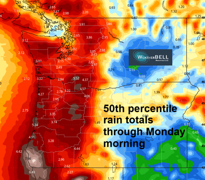
On Wednesday, the first in a series of weather systems arrives. Autumn starts to tumble towards winter. Just a little moisture (if any) is expected with this system. Dry, cooler (less than 70F) weather is forecast Thursday and Friday. After that: a damned good chance of rain this weekend. ALL members of the ECMWF ensemble have significant rain, a wetting rain, a soaking rain, for areas west of Hood River, and most of the member have a wetting rain for The Dalles as well. Fingers crossed.
Gardeners: this is an awesome opportunity for you to get a cover crop established, even if you (like me) no longer have water flowing. Get those seeds in the ground before this weekend, and you’re likely to get enough moisture followed by enough warmth for germination. Happy gardening. Safe travels. -TATAS
HEY! DON’T STOP READING! Is this community-focused forecast helpful to you? It sure is! It takes me a couple hours a day to write. Please join your friends and neighbors in contributing to keep it going. Venmo: @thegorgeismygym PayPal: twomirrors@gmail.com USPS: Temira / PO Box 841 / Hood River, Oregon 97031 You can test out the forecast subscription for a few days for free by signing up below. Easy! Do it!
MT HOOD SNOW FORECAST

CURRENTLY ON VACATION. WILL RETURN SOMETIME BEFORE THE START OF SKI SEASON AT MEADOWS, TIMBERLINE AND SKIBOWL. SAME GOES FOR THE NORDIC SKIING SEASON AT MEADOWS AND TEACUP!
