

GORGE WIND FORECAST
If you’re still seeing yesterday’s and it’s after 9am, try opening this in an incognito window
today’s gorge wind forecast
Hi friends! Super-active weather continues for a couple more days, and then we’ll switch into a more stable setup. That return to stable weather brings better agreement in the models, and those models are pretty darn excited about next Thursday’s Gorge wind forecast. That’s a long ways out to be penciling things in, but go ahead and do it. I did.
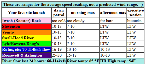
Looking at today, we have the lingering effects from a system that moved thought overnight. Westerlies are generally in the 10-13mph range west of The Dalles. Out east, the day started with 20ish near Rufus and 30ish between Arlington and Threemile. That wind is going to drop quickly. By midday, the west side will be holding at 10-13mph, and the east side will be down to 15-18mph. By mid-afternoon, as rain increases, the entire Gorge drops below 10mph. So you might as well go to the naked bike ride in Portland. What else do you have to do today? River flow over the last 24 hours was 68-114kcfs, river temp is 65.5F, and high temp forecast is 54F for Hood River and 58F out east.
RIVER FLOW FOR SITES BETWEEN AVERY (EAST OF THE DALLES) AND RUFUS: CLICK HERE FOR JOHN DAY DAM FLOW.
RIVER FLOW FOR SITES BETWEEN STEVENSON AND DOUG’S BEACH (WEST OF THE DALLES): CLICK HERE FOR THE DALLES DAM FLOW

tomorrow’s gorge wind forecast
A cold front swings through from the NNE on Monday as a low drops south towards California. Widespread east wind results. Because the wind will spill over the Cascades, it won’t be as strong on the river as gradients indicate. Still… peak wind looks to be mid-morning: 30-35mph at Iwash and 20-25mph at Stevenson with 20mph at Viento. In a fun twist, this setup gives us widespread easterlies at 15-20mph all the way out in to the desert. High temp: 51F in Hood River and 54-59F out in the desert under clearing sky.
extended Gorge wind forecast
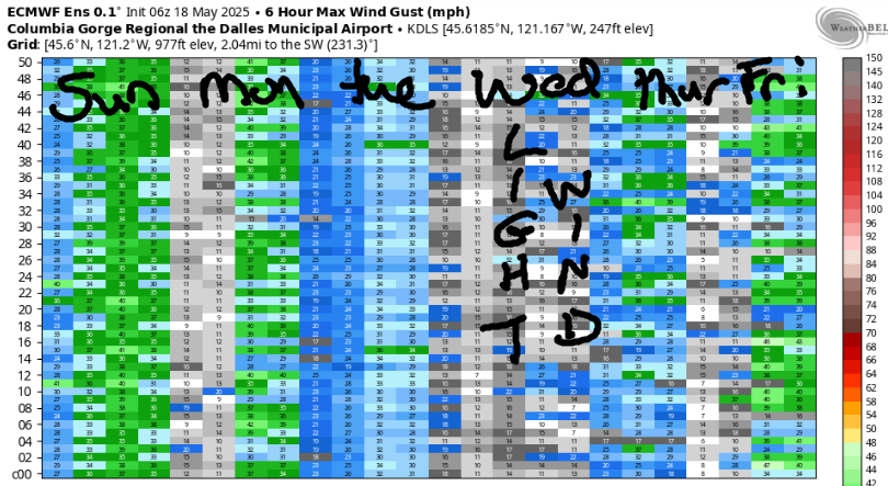
A more “normal” easterly setup is in the cards on Tuesday: Peak wind will be 20-25mph at both Stevenson and Iwash (Rooster) Rock with 20mph at Viento. That wind, per “normal” protocol, fades to 15mph or so in the afternoon. Westerlies return on Wednesday; we’ll probably see low 20s focused near Rowena and perhaps Rufus.
Models have a much more enticing plan for Thursday as a weak system swings through, warm temps return to the desert, and low clouds linger on the west side all day. All members of the ensemble are saying “windy” for Thursday; the GFS deterministic agrees with a forecast of 26-29mph for the Hatch. Some change in the forecast is likely, but for now, I’m going to risk green-lighting it. Lesser westerlies are likely on Friday, but we’re likely to see 17-20mph or more. Okie dokie. That’s it for now. Have an awesome day today!
Was that helpful? I knew it was! Guess what? All of this crucial work – from your personal wind and snow reports to the invaluable TATAS updates – is made possible by my relentless efforts. Maintaining this labor of love isn’t easy. Each daily forecast takes hours. Website hosting, weather model access, and back-end admin work takes time and money. That’s where you come in.
YOUR CONTRIBUTION MAKES A DIFFERENCE
- SUPPORT ACCURATE, HYPER-LOCAL WEATHER FORECASTING
- ENABLE ACCESS FOR ALL, EVEN THOSE WITH LESS MEANS
- SUPPORT A COOL HUMAN WHO WORKS HARD SO YOU CAN PLAY
Take a moment to click one of the buttons below. Donate $19.99 or more (how much does this forecast enhance your life?) and get the email in your inbox. Whether it’s a renewing subscription (auto-renew) or a one-time donation, every contribution makes a real difference. Help me keep this labor of love alive, so we can all continue playing, commuting, and living in the Gorge with peace of mind and the best weather forecasts possible. Thank you!


Hood River, Oregon 97031


JONES BEACH, SAUVIE ISLAND, & COAST FORECAST
CURRENTLY ON WINTER BREAK. WILL RETURN AS NEEDED.
BARE BONES HOOD RIVER WEATHER FORECAST
Clouds this morning with rain increasing throughout the day. Temps start near 50 and rise to the mid 50s. Light westerlies. 78% chance of rainbows. Monday will be partly cloudy then mostly clear. Temps start in the upper 30s and rise to the low 50s. Moderate easterlies. No rainbows. Tuesday will be mostly clear with a chance of frost then sunny. Temps start in the mid 30s and rise to the upper 50s. Calm wind early. Light easterlies later. No rainbows.
TEMIRA’S AWESOME TRAVEL ADVISORY SERVICE
HYPERLOCAL WEATHER FORECAST FOR THE COLUMBIA GORGE
THE DALLES, HOOD RIVER, WHITE SALMON, TROUT LAKE, STEVENSON, CASCADE LOCKS, PARKDALE, ODELL, HUSUM, BZ, MILL A, WILLARD, GOLDENDALE, RUFUS, ARLINGTON, boardman
Good morning, neighbors! It’s definitely not summer out there any more. I know this because people are dancing around the saukkah hut (THANKS, HOOD RIVER, FOR BUILDING SUCH A BIG ONE AT THE EVENT SITE AND MAKING US JEWISH PEOPLE FEEL SO WELCOME) and radiating joy out into this troubled world. You too can gather up some joy and humility and kindness and share it as we slide into the cold, dark, rainy season. Lack of sunshine doesn’t have to mean lack of warmth in your heart. Stoke the fire and keep it going!
Glenwood this morning
Up in Glenwood this morning, there are probably some real fires burning in real hearths: it’s 44 degrees and drizzling. That’s a hell of a lot warmer than it’ll be on Tuesday morning when a hard freeze is in stock for our Glenwood friends… Back to today… folks in Glenwood continue to frantically sew see-through costumes for the clothing-optional Emergency World Naked Bike Ride in Portland today – start point is Convention Center Plaza at 2:30pm. Wear your warmest skin.
Today’s Gorge weather forecast
For the rest of us today… light drizzle as far east as Mosier or Rowena early. Drizzle extends to the Arlington Triangle by late morning. Rainfall turns more assertive, aggressive, and downright wetter this evening as we see moderate to heavy rain extending as far east as Arlington. Thanks to all this cloud cover, and thanks to a cool trough aloft, temps only make it to the mid 50s in the west and high 50s out east. Wind will be 10mph or less west of The Dalles all day with westerlies at 25mph this morning to the east and 15-20mph this afternoon. Up in the mountains: rather blizzardy above 4000′, where WNW wind at 25-30mph drives orographic effects. Expect snow on Bennett Pass and other high elevation roads. Above 5000′ in orographically favored areas, 12-16” of new snow is possible. Sadly for skiers, the wind switches to easterly at 30mph midday Monday and messes up all the powder piled on the normally-leeward slopes.
Monday’s Gorge weather forecast
Ah yes, Monday. We start with drizzle as far east as Arlington. Rainfall slowly fades from east to west. It ends in South Wasco around 11am and ends in The Dalles around 2pm as a dry cold front sweeps in from the NE. Accompanying this system will be moderately strong east wind all through the Gorge: 25-30mph near Iwash Rock and Stevenson with 20mph east of Viento all the way east into the desert. Up in the hills: east wind at 20-30mph. This dry system starts to scour out the clouds except in places favored for easterly orographic effects, where rain continues until the air really drys out: Dufur, for example… any places along the east slopes of the Cascades. Highs: 50F to the west and 55F for The Dalles and 59F in the desert.
Extended Gorge weather forecast (contains frost)
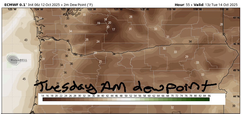
Clear sky, low humidity, calm wind, and 850mb temps at 2-3C set many of us up for a frosty Tuesday morning. Right along the river, and also west of Hood River where it’ll be breezy, frost is less likely. Anyone away from the river is likely to see a light frost (lowest elevations) or a freeze (Glenwood, High Prairie, Centerville, Cherry Heights, Parkdale, Odell, Mosier, Snowden, Appleton, Underwood, etc.). After the morning chill, the day turns sunny and dry. Highs will be right around 60F. Wind will be E 20-25mph near Stevenson and Iwash (schlong) Rock with light east wind to the east of Viento.
Wednesday, Thursday, and Friday looks warmer: 60-65F and sunnier, although there will be some clouds around on Thursday. Model agreement is pretty good all the way through the week. Next round of rain looks to arrive next Sunday sometime. Safe travels. -TATAS
HEY! DON’T STOP READING! Is this community-focused forecast helpful to you? It sure is! It takes me a couple hours a day to write. Please join your friends and neighbors in contributing to keep it going. Venmo: @thegorgeismygym PayPal: twomirrors@gmail.com USPS: Temira / PO Box 841 / Hood River, Oregon 97031 You can test out the forecast subscription for a few days for free by signing up below. Easy! Do it!
MT HOOD SNOW FORECAST

CURRENTLY ON VACATION. WILL RETURN SOMETIME BEFORE THE START OF SKI SEASON AT MEADOWS, TIMBERLINE AND SKIBOWL. SAME GOES FOR THE NORDIC SKIING SEASON AT MEADOWS AND TEACUP!

Leave a Reply