MT. HOOD WEATHER FORECAST

Hey skiers and snowboarders! Sunny, dry weather continues for the long haul. Good thing Mt. Hood’s still running over 100% of season-average snowpack right now! Next chance of new snow looks to be 10-14 days out. Wow. This is turning into a long stretch of sunshine, isn’t it? Snow conditions right now are a mix of granular, partially-transformed snow, and (in some shady areas) hardpack. Wax today: red if you’re up high where it’s 30-36F, and blue if you’re down low (where it’s 10-17F but will warm up). Clothing: dress for the range, cuz it’s cold down low and warm up high with a bit of a breeze!
SUNDAY
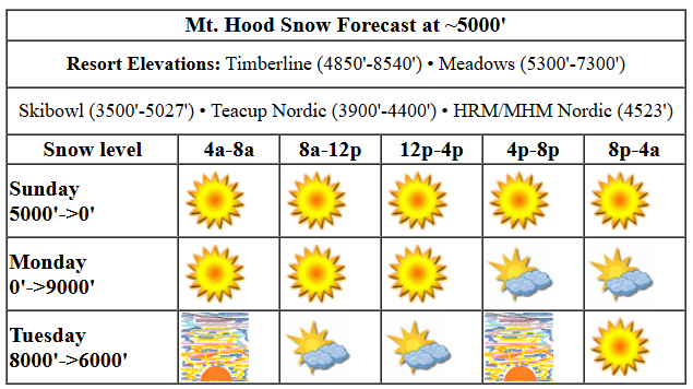
Sunday’s weather will be mostly clear all day. The free air freezing level (above the inversion), will be around 5000′ all day. That said, cold air surges in on the east side, and this could make for some wildly varying temps across the elevation profile. Wind today will be NNE 10-20 early, NE 15-20 in the afternoon, and N 20-25 after midnight.
MONDAY
Monday will be sunny in the morning with high clouds in the afternoon. We’ll start the day with another inversion – very cold temps down low in the valleys (Skibowl, Summit, and Nordic areas, I’m talking to you!) and near-freezing temps aloft. Morning temps will vary wildly: east side air will be -7C (upper teens), and west side air will be +1C (32-34F). By afternoon, the free air freezing level rises from 0′ to 9000′ with temps climbing to the upper 30s at 5000′. Wind: E 20-25 in the morning, light westerly in the afternoon, and W 25 after midnight. That 20mph east wind could cause some trouble at T-Line, although that’s right on the edge of trouble/no trouble. Meadows tends to do fine in easterlies, even strong easterlies.
Liking this forecast?
TUESDAY-WEDNESDAY
Moving on to Tuesday: temps pop above freezing above the inversion and stay there as a weak, dry system blows through. The free air freezing level will be 8000′ in the morning, 6500′ in the afternoon, and 6000′ after midnight. Max temps will be in the mid 30s, and they should be there most of the day. Below the inversion: quite cold, once again. Wind will be W 25 in the morning, WNW 25-35 in the afternoon, and NW 10-15 after midnight. Wednesday: clear, sunny, above freezing, and light wind.
THURSDAY AND BEYOND
Clear, warm, calm weather is forecast Thursday. A (probably) dry weather system swings through from the NNW on Friday and brings back another round of cold temps for all elevations. After that: well, generally speaking, things look dry. That’s good for me, ‘cuz I’ll be on a meditation retreat and totally offline until the following Thursday, which is right about when models hint at precipitation finally returning to Mt. Hood. Fingers crossed!
Was that helpful? I knew it was! Guess what? All of this crucial work – from your personal wind and snow reports to the invaluable TATAS updates – is made possible by my relentless efforts. Maintaining this labor of love isn’t easy. Each daily forecast takes hours. Website hosting, weather model access, and back-end admin work takes time and money. That’s where you come in.
YOUR CONTRIBUTION MAKES A DIFFERENCE
- SUPPORT ACCURATE, HYPER-LOCAL WEATHER FORECASTING
- ENABLE ACCESS FOR ALL, EVEN THOSE WITH LESS MEANS
- SUPPORT A COOL HUMAN WHO WORKS HARD SO YOU CAN PLAY
Take a moment to click one of the buttons below. Donate $19.99 or more (how much does this forecast enhance your life?) and get the email in your inbox. Whether it’s a renewing subscription (auto-renew) or a one-time donation, every contribution makes a real difference. Help me keep this labor of love alive, so we can all continue playing, commuting, and living in the Gorge with peace of mind and the best weather forecasts possible. Thank you!


Hood River, Oregon 97031


GORGE WIND FORECAST

Hi friends! Cold weather and east wind sticks around for Sunday and Monday. Models are teasing us with the possibility of westerlies both Tuesday and Thursday. Why the surprise winter westerlies? An unseasonably strong ridge of high pressure is hanging offshore, and any time anything disturbs the corresponding inland high, that offshore ridge turns the wind onshore. Okay, back to Sunday: Light easterlies this morning pick up into the afternoon. Stevenson rises to 25mph, and Iwash (Rooster) Rock, which started at 20mph, slowly rises to 30-35mph. River flow over the last 24 hours was 103-144kcfs, river temp is 42.08F, and high temp forecast is 39F with sunshine. Brr.
Monday starts with 50mph at Iwash and 30mph at Stevenson. The wind holds until early afternoon, and then it drops a bit. Stevenson finishes up with 15-20mph, and Iwash ends the day with 35mph. High temp: 36F with increasing high clouds during the day. Tuesday starts with E 15mph at both Stevenson and Iwash. Models like the idea of westerlies at 21-24mph from Stevenson to Hood River (calm to the east) from mid-morning on into the afternoon. High temp: 42F with high clouds in the morning and sun in the afternoon. Again: brr. Dress extra warmly, and keep an eye on your buddies.
BARE BONES WEATHER FOR HOOD RIVER
Clear sky this morning stays that way. Temps start in the mid 20s and rise to the upper 30s. Light easterlies. No rainbows. Monday starts clear or with a tiny Nothing and finishes with high clouds. Temps start in the low 20s and rise to the mid 30s. Light to moderate easterlies. No rainbows. Tuesday will be high overcast and partly Nothing early then clear. Temps start in the low 20s and rise to the low 40s. Light east wind early. Moderate west wind later. No rainbows.
TEMIRA’S AWESOME TRAVEL ADVISORY SERVICE (DETAILED WEATHER FORECAST FOR THE GORGE)

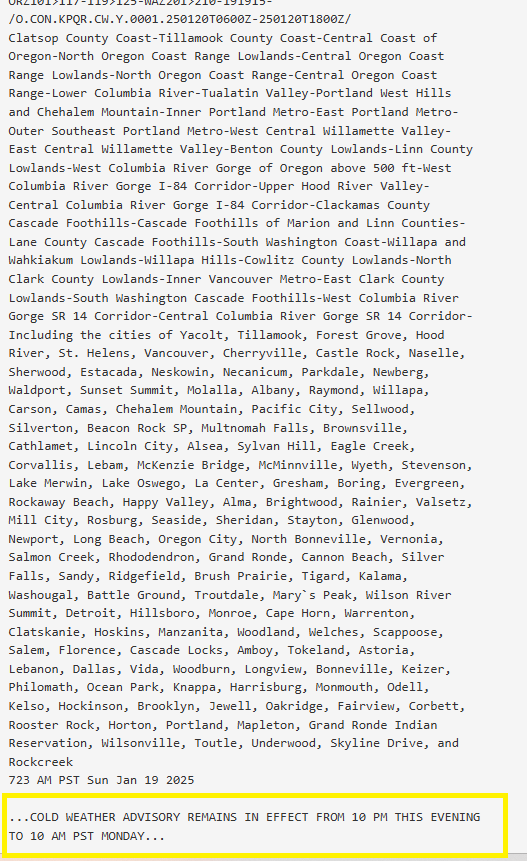
Good morning, neighbors! Exciting news this morning after a week of rather boring weather: we’ve qualified for a “Cold Weather Advisory” from NWS. Wow. Nothing like taking the excitement out of a bit of interesting weather by giving it a boring name. Let me rename this for you: we’re now in a Chicken Stock Warning: the weather outside is cold enough for enough hours of the day that if you make a giant pot of chicken stock, you can put it outside to cool without disturbing the sensibilities of your local food inspector. I made that last part up, but for reals, if I had a bunch of chicken bones (I’m out, sadly), I’d be making a huge pot of stock.
SUNDAY
On to the weather for Sunday… let’s check in with Glenwood. It’s 14F there this morning with a dewpoint of 10F. This officially qualifies for a “Fucking Cold Warning”. In other cold-weather news, could someone please let me know if there’s ice skating and hockey games happening at Laurence Lake or other locations? Thank you for satisfying my never-ending curiosity about all things weather.
Weather for the rest of Sunday: it’ll be chilly all day, chilly enough for a Chili Weather Advisory. If you make some, I’d like some, especially if you also make cornbread. Temps don’t crest 40 degrees today, but hey, at least it’ll be sunny. Easterlies rise from 20mph at Iwash (dick) Rock to 35mph this afternoon. Stevenson’s wind picks up to 20-25mph, which gives us a windchill reading of “too cold”.
MONDAY
Dewpoints drop even more Sunday night, which allows us to start even colder on Monday morning. Models suggest some places will be cold enough for a spot or two of Nothing cloud, but most places should be crystal clear and in the mid-20s or less. High clouds move in during the afternoon, hopefully placed perfectly for a stellar sunset. High temp: mid 30s along the river. Wind will be E 50mph at Iwash (dong) Rock in the morning and 35mph in the afternoon. Stevenson: 30mph early and 15-20mph in the afternoon. Hills: up to 20mph out of the east. Brr. In other Sunday news, Tik Tok has gone dark, which means (fortunately for all of you), that I no longer have a good place to post video clips of me learning to twerk. And you don’t have a place to search for videos of me doing that. And to tell you the truth, I haven’t posted ANY videos on Tik Tok, so … yeah… not sure where I was going with that!
Let’s get back to the weather.
TUESDAY
Another frigid morning is in the cards on Tuesday, but the presence of some high clouds might just make it slightly less cold than expected. It could also be a pretty sunrise. Try to take pictures, and your hands will likely freeze to your camera. Maybe this goes without saying, but you’ll want to refrain from licking anything if you are outside. Try it, and your tongue will freeze to the sub-freezing object. A weak system brushes by during the day and turns the wind westerly as far east as Hood River or Mosier. When that happens, temps rise into the low 40s. Maybe. It’ll be pretty dang cold all around the region on Tuesday morning, so maybe we won’t get that “warm”, which isn’t warm at all.
AFTER TUESDAY
After Tuesday, we’re back into a cold/dry pattern for the extended period. Head up into the hills for warmer conditions: models have the ski slopes in the upper 30’s or warmer for Wednesday and Thursday. Generally speaking, the weather is likely to remain dry (exception: possible light precip Friday) all the way through the middle of the following week. Wow. This is one long stretch of dry weather. Stay warm out there. Safe travels. -TATAS
HEY! DON’T STOP READING! Is this community-focused forecast helpful to you? It sure it! It takes me a couple hours a day to write. Please jump in a contribute to keep it going. Venmo: @thegorgeismygym PayPal: twomirrors@gmail.com USPS: Temira / PO Box 841 / Hood River, Oregon 97031 You can test out the forecast subscription for a few days for free by clicking this link: https://subscribepage.io/YhevGc


