

GORGE WIND FORECAST
If you’re still seeing yesterday’s and it’s after 9am, try opening this in an incognito window
today’s gorge wind forecast
Hi friends! It’s difficult to write a recreation-focused wind forecast right now without acknowledging the harm the wind is causing as it spreads the Burdoin Fire through local communities. Please keep those folks in mind today while you are playing in the wind. We’ll see 20mph+ today followed by somewhat lesser wind Monday, Tuesday, and Wednesday. Ensembles suggest stronger westerlies will return Thursday-Saturday as a midweek bump in the heat transitions to cooler weather for the end of the week.
A few PSAs this morning: there’s a swap meet at Windance this morning; there are Cabrinha demos at the Waterfront Park 11am-3pm today; if you lost an Ion wetsuit on the freeway near Hood River, I have it, so please message me; SR-14 remains closed east of Bingen; Lyle and Doug’s are in the Level 3 evacuation zone – no windsports there; if you see planes or helicopters scooping water in the area where you’re recreating, go somewhere else. There was a close call at Tunnel 4 a couple days ago, and close calls interfere with fire operations. Thanks to those folks for recognizing the situation and choosing to go elsewhere so the planes could scoop! Fire operations, of course, are priority right now.
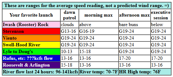
Today, Sunday, started with pressures of 30.05/29.95/29.91 for gradients of 0.10 (PDX-DLS) and 0.04 (DLS-PSC). This suggests we’ll see wind at least as far east as Rufus today. But there’s a caveat, as you might have guessed from the presence of clouds: we’re under the influence of a trough (cool air aloft, essentially) today, which will make the wind gustier and more unreliable than usual. That said, thicker clouds on the west side than on the east will support decent cross-Cascade thermal gradients today. So… For the morning, expect up-and-down 19-24 between Viento and Swell with 14-17 at Stevenson, Hood River, and Mosier. To the east, we’ll have 10-13mph between Lyle and Arlington to start the day. Afternoon wind fills in with up-and-down, gusty 20-25 from Stevenson to Avery with 17-20mph near Rufus (potentially a bit more) and 14-17mph at Arlington. Models also hint at the possibility of rain east of The Dalles this evening. That would probably shut down the wind where the raindrops are falling, or at least knock the speed and quality down. River flow over the 24 hours was 96-141kcfs … ish… the website for John Day is down right now. River temp is 70.7F, and high temp forecast is 76F for Hood River and 84F out near Rufus.
RIVER FLOW FOR SITES BETWEEN AVERY (EAST OF THE DALLES) AND RUFUS: CLICK HERE FOR JOHN DAY DAM FLOW.
RIVER FLOW FOR SITES BETWEEN STEVENSON AND DOUG’S BEACH (WEST OF THE DALLES): CLICK HERE FOR THE DALLES DAM FLOW

tomorrow’s gorge wind forecast
On Monday, a low pressure system moves inland. This minimizes the cross-Cascade temp gradient and increases instability. The combo is not conducive to strong wind. We’ll have 10-15mph to start from Viento to Doug’s with less than 10mph to the east and west of that zone. Midday wind builds to 14-17mph from Stevenson to Avery. Afternoon: 12-15mph from Stevenson to Hood river, 17-20mph from Lyle to Rufus, and 10-13mph east of Rufus to Arlington. High temp: 81F for Hood River under partly cloudy sky with a slight chance of thunderstorms and/or showers. Any storms that do develop have the potential to shut down the wind and zap you with lightning, so please clear the river if you hear thunder!
extended Gorge wind forecast
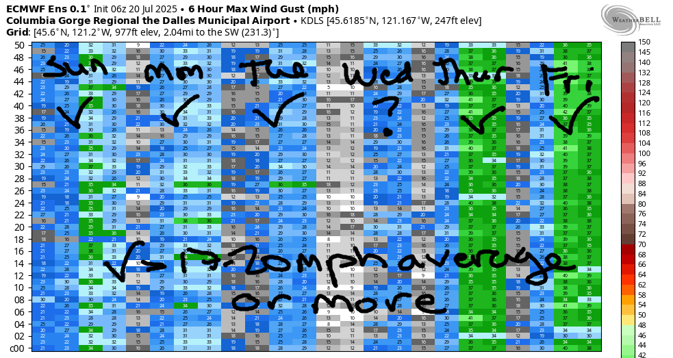
Moderate westerlies continue on Tuesday as the influence of a low persists. Westerlies, as of now, are forecast to be in the 17-20mph range from Viento to Swell in the morning. Afternoon: 14-17mph from Stevenson to Hood River, 19-22mph from Mosier to Avery, and 14-17mph near Rufus. High temp: 85F for Hood River and 90F at Rufus. Slightly lighter, slightly later-developing wind is in the cards for Wednesday, when temps will rise to 90F in Hood River. That’s looking like the day to spray, at least for me! Cooling begins on Thursday and results in at least a three day stretch of stronger westerlies. At this point, they don’t look nuking, but 25mph average speeds seem likely somewhere Thursday-Saturday. Beyond that, uncertainty increases, but westerlies are likely to continue. That’s it for now. Keep our fire-affected friends in your minds today as you play in the wind. Be safe out there!
Was that helpful? I knew it was! Guess what? All of this crucial work – from your personal wind and snow reports to the invaluable TATAS updates – is made possible by my relentless efforts. Maintaining this labor of love isn’t easy. Each daily forecast takes hours. Website hosting, weather model access, and back-end admin work takes time and money. That’s where you come in.
YOUR CONTRIBUTION MAKES A DIFFERENCE
- SUPPORT ACCURATE, HYPER-LOCAL WEATHER FORECASTING
- ENABLE ACCESS FOR ALL, EVEN THOSE WITH LESS MEANS
- SUPPORT A COOL HUMAN WHO WORKS HARD SO YOU CAN PLAY
Take a moment to click one of the buttons below. Donate $19.99 or more (how much does this forecast enhance your life?) and get the email in your inbox. Whether it’s a renewing subscription (auto-renew) or a one-time donation, every contribution makes a real difference. Help me keep this labor of love alive, so we can all continue playing, commuting, and living in the Gorge with peace of mind and the best weather forecasts possible. Thank you!


Hood River, Oregon 97031


JONES BEACH, SAUVIE ISLAND, & COAST FORECAST
Wind northerly unless otherwise indicated. For coast, it’s North/Central/South with the “central” at approximately Florence. Swell forecast from NWS for central coast. Jones: westerly unless otherwise stated. Sauvie Island: northerly unless otherwise stated. Coast Sunday: LTNW/LTNW/N20, NW swell 3′ at 7 seconds. Monday: LTNW/LTNW/N20, NW 3′ @ 8. Tuesday: LTNW/NW10/N20-25, NW 3′ @ 10. Jones Sunday: 9-12. Monday: 17-20. Tuesday: 15-18. Sauvie Island Sunday: 7-10. Monday: 11-14. Tuesday: 10-13.
BARE BONES HOOD RIVER WEATHER FORECAST
Overcast sky sticks around all day. Temps star tint he low 60s and rise to the mid 70s. Chance of light rain overnight. Moderately strong westerlies. No rainbows. Monday will be mostly cloudy to start with a chance of light rain showers and partly cloudy later with a slight chance of thunder. Temps start in the upper 50s and rise to the low 80s. Moderate westerlies. No rainbows. Tuesday will be partly cloudy then clear. Temps start in the upper 50s and rise to the mid 80s. Moderate westerlies. No rainbows.
TEMIRA’S AWESOME TRAVEL ADVISORY SERVICE
HYPERLOCAL WEATHER FORECAST FOR THE COLUMBIA GORGE
THE DALLES, HOOD RIVER, WHITE SALMON, TROUT LAKE, STEVENSON, CASCADE LOCKS, PARKDALE, ODELL, HUSUM, BZ, MILL A, WILLARD, GOLDENDALE, RUFUS, ARLINGTON, boardman
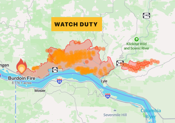
Good morning, neighbors! My heart sure is hurting this morning looking at the Burdoin Fire info – 8776 acres with fire burning out of control on both sides of the Klickitat River. Whether the fire is directly affecting you or not, it affects you if you live here: we’re many small towns, but we’re one big community. As far as I’m concerned, there’s only one possible response to each other in the face of this fire and the destruction caused by the Rowena Fire: kindness and care. No matter our political beliefs, no matter our deeply held values, the only possible, wise, realistic, and reasonable response is to treat each other with an extra measure of kindness while we face the fear and destruction of out-of-control fire. For the most up-to-date info, check WatchDuty. If you have the financial resources, please consider making a donation or becoming a member to support their awesome work. Raod news: SR-14 remains closed west of Bingen, and parts of 142 and the Centerville Highway are closed as well.
glenwood this morning and today’s gorge weather forecast
And with that, let’s move on to the forecast and our morning check-in with Glenwood: it was 50 degrees and cloudy there. Early this morning, everyone was sipping their coffee (with heavy cream, because it’s Sunday) and contemplating ways to support folks who are evacuated. We’ll all have cloudy sky today as a trough (it’s a weather thing associated with cool air) hangs out with us. This will suppress high temps. We’re expecting mid 70s to the west, low 80s in (the the The Dalles) and mid 80s to the east. West wind will be very up-and-down and gusty today in the face of this weather system: 15-25mph this morning from Stevenson to Mosier with 10-15mph from Mosier to Arlington. Afternoon wind rises to 20-25mph (that’s average speed on the river, not gusts) from Stevenson to Avery with 15-20mph east of Avery to the Arlington equilateral Bermuda triangle. In a fun and hopeful twist, models are suggesting the possibility of some rain, mostly east of Rowena and along the east slopes of the Cascades, as this trough nudges things around in the upper atmosphere. The 10th percentile has no rain at all. The 90th percentile gives us 0.2” to 0.5” by Monday afternoon, in part due to the potential for thunderstorms on Monday.
monday’s gorge weather forecast
Speaking of Monday: it opens with temps in the upper 50s most places. Low clouds in the west are complemented by a mix of mid and high clouds all the way east to Idaho. Maybe it’ll rain. Maybe it won’t. Maybe we’ll see thunder. Maybe we won’t. Let’s vote for “won’t”, because the last thing we need is lightning starting more fires. Temps Monday afternoon rise to the low 80s (west and far east) and mid 80s (the-the-the The Dalles). West wind starts the day at 10-15mph between Viento and Murdoch. Westerlies rise to 15mph west of Mosier and 15-20mph from Mosier to Rufus in the afternoon with 10-15mph near Roosevelt and Arlington. Clouds stick around in some form pretty much all day.
tuesday’s gorge weather forecast
Tuesday morning kicks off with some reassuring and calming low clouds in the west and clear sky to the east. Afternoon sees things destabilize, which kicks off a few thunderheads and lots of Little Fluffy Clouds. After a upper-50s start, temps rise to 85 (west), 91 (Dallesport), and 89 (Pascoland). West wind will be 15-20mph to start from Viento to Hood River with afternoon wind at 20mph (or so) between Mosier and Avery with 15-20mph west of Mosier and east of Avery to Rufus.
STOP BEING WINDY!!!
extended gorge weather forecast
I’m not sure who I was yelling at there, but we sure could use a break from the wind. We may see a break on Wednesday, when it will be hotter (90-95) or at least a lessening, but stronger wind is almost certain to return on Thursday and Friday, when it will be cooler (85-90). Okay, peeps. There’s enough hurt in the Gorge right now. If you feel up to it, take on the challenge to be kind to yourself and others today. Why yourself? Because if you’re cruel to yourself, it sets the stage for you to be cruel to others when you’re not on guard. Better to be kind to yourself and not have to fight those urges to ill-will. Safe travels. -TATAS
HEY! DON’T STOP READING! Is this community-focused forecast helpful to you? It sure is! It takes me a couple hours a day to write. Please join your friends and neighbors in contributing to keep it going. Venmo: @thegorgeismygym PayPal: twomirrors@gmail.com USPS: Temira / PO Box 841 / Hood River, Oregon 97031 You can test out the forecast subscription for a few days for free by signing up below. Easy! Do it!
