

MT HOOD WEATHER FORECAST
Good morning skiers and snowboarders! Today’s Mt Hood weather is definitely pow day weather – expect dumping snow and storm skiing all day long. We could see a brief period of mixed precip tonight, and then it’s right back into snow on Sunday. Less snow Monday and Tuesday gives way to dry weather on Wednesday, and then we’re right back into an extended period of snowfall for our slopes. March: the most magical month on Mt. Hood!
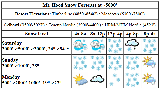
Let’s take a look at Saturday, shall we? Resorts have picked up about a foot of snow in the last 24 hours, and they’ll pick up more powder today. Practice deep snow safety! The snow level starts around 3000′ and holds through the afternoon. Temps at 5000′ may jump to 34F for a few hours this evening, but intense precip rates could also keep the precip as snow rather than something else. It’s going to be close. During the day, we’re expecting 0.6” water equivalent (WE), for 6-9” new snow thanks to orographic (wind + terrain) assistance. Overnight, another 1.0” WE is in the cards. Some of that is likely to come in as snain (very wet snow), so let’s call it 7-9” dense new snow that turns increasingly dry after midnight. We’ll probably see a switch to rain at Teacup and Skibowl for a period of time. Wind starts the day at W 50-55mph, enough to cause a couple lifts to go down and others to run slowly. That wind drops just enough to stop the problems by late morning. For the afternoon, we have WSW 35mph, and overnight, W 30mph. That’s one heck of a powder day on tap! Go get it!
Snowfall continues on Sunday. The snow level will be 3000′ all day and will drop to 500-1000′ under partly cloudy sky overnight. Temps start around 28F, hold all day, and drop to 25F or less overnight. About 0.5” WE is forecast during the day for 5-7” new snow (again, orographic assistance will help). A couple more inches of snow fall in the evening before the sky turns partly cloudy and then turns overcast after midnight. Wind will be W 30 in the morning, WNW 20-30 in the afternoon, and NW 10-20 after midnight.
A dry, cloudy morning on Monday gives way to snow around noon. The snow level will be 500′ early, 2000′ in the afternoon, and 1000′ after midnight. Temps start in the upper teens and rise to 27F or so. About 0.2” WE is forecast before 5pm for a couple inches of new snow. Overnight, 0.3” WE falls for 3-4” powder. Wind: NW 10-20 in the morning, WNW 20-30 int eh afternoon, and W 30 overnight.
extended mt hood weather forecast
Tuesday kicks off cold (upper teens) and breezy (W 30mph) with lingering flurries. Sun midday gives way to clouds in the evening. Wednesday looks cloudy and dry all day with snow returning in the evening. After that: more snow every day. That’s how March should be – a snowpack building month! See you out there in the powder!
Was that helpful? I knew it was! Guess what? All of this crucial work – from your personal wind and snow reports to the invaluable TATAS updates – is made possible by my relentless efforts. Maintaining this labor of love isn’t easy. Each daily forecast takes hours. Website hosting, weather model access, and back-end admin work takes time and money. That’s where you come in.
YOUR CONTRIBUTION MAKES A DIFFERENCE
- SUPPORT ACCURATE, HYPER-LOCAL WEATHER FORECASTING
- ENABLE ACCESS FOR ALL, EVEN THOSE WITH LESS MEANS
- SUPPORT A COOL HUMAN WHO WORKS HARD SO YOU CAN PLAY
Take a moment to click one of the buttons below. Donate $19.99 or more (how much does this forecast enhance your life?) and get the email in your inbox. Whether it’s a renewing subscription (auto-renew) or a one-time donation, every contribution makes a real difference. Help me keep this labor of love alive, so we can all continue playing, commuting, and living in the Gorge with peace of mind and the best weather forecasts possible. Thank you!


Hood River, Oregon 97031


GORGE WIND FORECAST

Hi friends! Active weather continues, and along with that comes opportunities to catch some gusty westerlies over the next four days. Today sees a strong system swing through the Gorge. We’ll be relying on accompany strong upper-level wind touching down to the surface to give us wind on the river. This is a setup that generally favors Rufus, but it’s also a setup that tends to under-perform model predictions.
today
Models give us a period of 18-22 from Stevenson to Doug’s this morning (more at Viento, as it normal with frontal passages) and 24-27 out east. There’s a hint that we could see short period of 27-31 from Avery to Boardman late morning. Following that, the wind falls back to 23-26 from Avery to Arlington and 20-23 east of Arlington out to Boardman. In the afternoon, areas west of The Dalles drop to 10mph or less. Remember that those eastern Gorge sensors tend to read high compared to those in the west; 23-26 at Rufus/Arlington is like 18-20 at the Hatch. River flow over the last 24 hours was 129-196kcfs, river temp is 43F, and high temp forecast is 48F with a break in the rain midday followed by heavy rain this afternoon and evening.
after today
Sunday sees a low move inland early in the day. This gives us a quick burst of 22-25 from Maryhill to Arlington with 11-14 from Stevenson to Avery. The wind drops below 10mph midday and rises to 13-16 from Stevenson to Rufus in the afternoon. High temp: 37F with cloudy sky and afternoon rain. Monday sees a brief period of ridging. In response, the wind starts calm. Afternoon westerlies pick up to 19-22 (potentially more – the ensembles are enthusiastic) from Stevenson to Doug’s and potentially to Rufus. High temp: 50F with clouds in the morning and sun in the afternoon. Another round of moderate west wind is possible on Tuesday. See you on the river!
BARE BONES HOOD RIVER WEATHER FORECAST
Rain this morning, a break midday, heavy rain late afternoon into the night. Temps start in the low 40s and rise to the upper 40s. Moderate westerlies. 99.99% chance of rainbows. Sunday will be cloudy with drizzle in the afternoon. Temps star tin the upper 30s and rise to the upper 40s. Light to moderate westerlies. 99% chance of rainbows. Monday will be cloudy in the morning and mostly clear in the afternoon. Temps start in the mid 30s and rise to 50 or so. Calm wind early. Moderate westerlies later. 1% chance of rainbows.
TEMIRA’S AWESOME TRAVEL ADVISORY SERVICE
HYPERLOCAL WEATHER FORECAST FOR THE COLUMBIA GORGE
THE DALLES, HOOD RIVER, WHITE SALMON, TROUT LAKE, STEVENSON, CASCADE LOCKS, PARKDALE, ODELL, HUSUM, BZ, MILL A, WILLARD, GOLDENDALE, RUFUS, ARLINGTON, boardman
Good morning, neighbors! My what a rainy day we have on tap, and tonight will be even rainier than today. Unless something changes, the bulk of tomorrow’s rain will stay to the south of the Nch’i Wana and then… oh fuck it, let’s just talk about the 24th, 25th, and 26th, when the Euro ensemble thinks we could see 60-70 degrees! Hooray! Record high temps for those three days are 74-75 degrees, so 70 isn’t unreasonable.
glenwood and the tatas eootd
Back to today – Glenwood started the day 35 degrees and breezy. TATAS Executive Order Of The Day: everyone has to read the book “How Democracies Die” and pass a test on it.
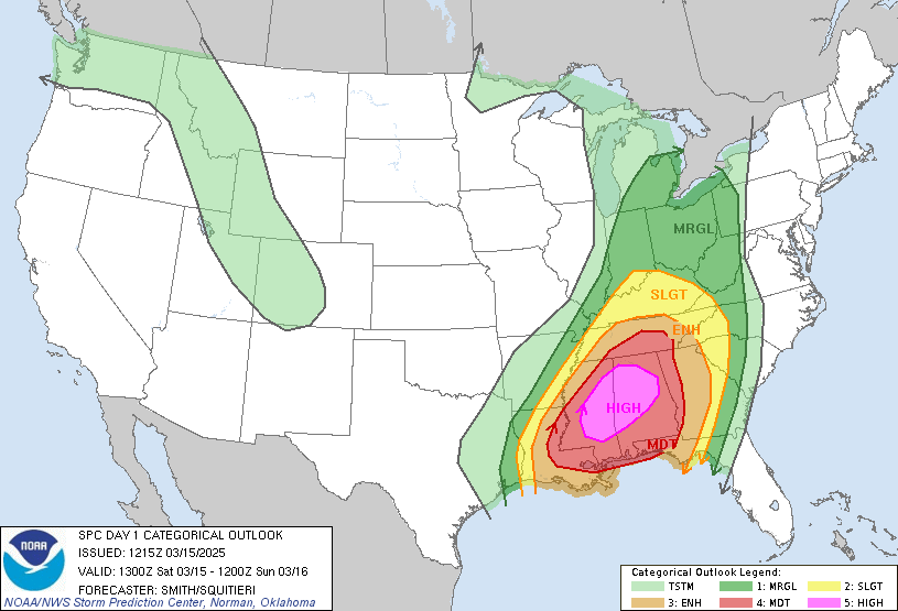
Before we dive in – let’s look at the SPC convective outlook for today. We have a shaft of instability across Washington and the Rockies. This shaft is aiming at a love canal of storm possibility centered over Alabama and Mississippi.
today and sunday
Back to the rainbows we’ll have today – there will be a LOT of them. That’s because Mother Nature, while not 100% gay, is totally cool with all the colors and letters of the rainbow. We’ll have showers this morning on the west side with dry weather. Later: POURING rain. From 2pm on through 2am, it’ll be absolutely pouring between the metro area and Hood River. Heavy rain extends all the way to Arlington and south into SW/Sherm this evening. That band of rain slides south of the Nch’i Wana after midnight and hangs out there all day Sunday. Down near Gold Beach, rainfall rates will exceed 0.25”/hr at times on Sunday. Aren’t you glad you’re here-not-there? High temps both days will be in the upper 40s here in the Gorge. Snow level: 3000′ or so. A little snow, a trace to an inch or so, is possible near Parkdale on Sunday night.
Saturday’s wind: 15-20 west of The Dalles and 20-30 east of The Dalles. Sunday: 20-25mph east of The Dalles early and 10-15mph all through the Gorge for the rest of the day.
monday and beyond
On to Monday: calm wind and partly high overcast sky sets us up for a chance of frost. The sun comes out in the afternoon and takes temps up to 50F. Most of us will be dry, but Cascade Locks won’t. Nope. It’ll be rainy all day. Areas above 1500′ west of Hood River could pick up a little snow on Monday night. We’ll look at that more closely tomorrow. Frost/freeze chances are high on Tuesday morning as partly cloudy sky combines with 850mb temps at -6C. Wednesday: dry until the evening when rain returns and sticks around for a while. Until it doesn’t. Until the 24th, 25th, and 26th, when it fucking better be 70 degrees! Safe travels. -TATAS
HEY! DON’T STOP READING! Is this community-focused forecast helpful to you? It sure is! It takes me a couple hours a day to write. Please join your friends and neighbors in contributing to keep it going. Venmo: @thegorgeismygym PayPal: twomirrors@gmail.com USPS: Temira / PO Box 841 / Hood River, Oregon 97031 You can test out the forecast subscription for a few days for free by signing up below. Easy! Do it!
