

MT HOOD WEATHER FORECAST
Hey skiers and snowboarders! Multiple days of light snowfall are in the forecast this week. Heavier snowfall is possible Sunday night and Tuesday into Wednesday. A warming trend asserts itself late next week and sets the mountain up for another round of spring skiing. By that point, I’ll be tucked into my month long meditation retreat; I’ll see you again early in May. But I’m here a few more days, so let’s talk about today…
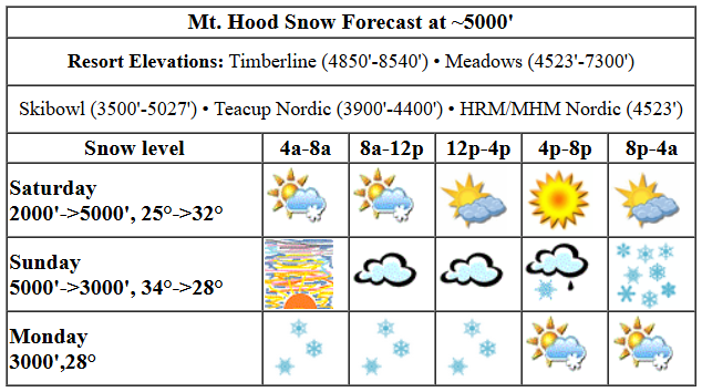
today’s mt hood weather forecast
Saturday starts with some light terrain-driven snow flurries. Those stick around for a few hours this morning before the sky turns mostly clear this afternoon. The snow level will be around 2000′ early, 3500′ this afternoon, and around 5000′ overnight. Temps at 5000′ will be in the mid 20s this morning, around 32F this afternoon, and up to 34F overnight if the sky turns cloudy early enough to prevent the regularly scheduled overnight cooling. Snowfall: just a trace today. Snow surface: frozen granular with some hardpack. And yes, it did refreeze last night, so expect hard/fast conditions early. Wind today will be W 15-20 in the morning, Light/variable this afternoon, and SE 15 overnight.
sunday’s mt hood weather forecast
Sunday looks high overcast to start with increasing clouds in the afternoon and mixed precip overnight as an offshore low sends a system our way. The snow level will be around 5000′ in the morning, 5500′ in the afternoon, and it’ll slowly fall to about 3000′ overnight. Temps will be in the mid 30s all day and will fall to the upper 20s overnight. We’re expecting up to 0.6” WE overnight. This may start as snain, but will switch to snow. Call it 3-4” dense new snow at 5000′ with more up higher.
extended mt hood weather forecast
Light snowfall is forecast Monday morning and Monday overnight with partly cloudy weather midday. The snow level will be around 3000′ all day with temps in the upper 20s. Wind: WSW 20 all day. Total snowfall for the 24 hours period will be 2-3”. Heavier snowfall is forecast on Tuesday, perhaps half a food. After that? Dry weather returns with a couple of cooler day before warmer weather makes a showing at the end of next week. Have a great day on the snow!
Was that helpful? I knew it was! Guess what? All of this crucial work – from your personal wind and snow reports to the invaluable TATAS updates – is made possible by my relentless efforts. Maintaining this labor of love isn’t easy. Each daily forecast takes hours. Website hosting, weather model access, and back-end admin work takes time and money. That’s where you come in.
YOUR CONTRIBUTION MAKES A DIFFERENCE
- SUPPORT ACCURATE, HYPER-LOCAL WEATHER FORECASTING
- ENABLE ACCESS FOR ALL, EVEN THOSE WITH LESS MEANS
- SUPPORT A COOL HUMAN WHO WORKS HARD SO YOU CAN PLAY
Take a moment to click one of the buttons below. Donate $19.99 or more (how much does this forecast enhance your life?) and get the email in your inbox. Whether it’s a renewing subscription (auto-renew) or a one-time donation, every contribution makes a real difference. Help me keep this labor of love alive, so we can all continue playing, commuting, and living in the Gorge with peace of mind and the best weather forecasts possible. Thank you!


Hood River, Oregon 97031


GORGE WIND FORECAST

Hi friends! Marginal westerlies are on tap today and Monday, and then there’s at least some chance of stronger westerlies Tuesday or Wednesday. Easterlies could hold on long enough on Sunday to get you on the water. It’s worth mentioning that river flow is now over 200kcfs, which means Rufus is probably out for paddling, but not for other sports. That flow should also kick up the swell for Arlington and Threemile. Okay. Saturday starts with light onshore gradients. Weak high pressure shifts inland today, and a very weak thermal gradient kicks in late. This gives us afternoon westerlies at 11-14 from Stevenson to Swell and from Avery to Arlington. Between Mosier and Doug’s, we could see 14-17. A period of 14-17 isn’t out of the question at the Hatch, but it’s not super likely either. River flow over the last 24 hours was 213-247kcfss, river temp is 47.1F, and high temp forecast is 56F with clouds in the morning and sun later.
A low spins offshore on Sunday, and that turns the wind easterly. As of this morning, models give us 25-30mph at Iwash (Rooster) Rock and Stevenson through late morning, perhaps just long enough for the paddle crew to catch one lap. The wind holds at 25mph at Iwash into late afternoon. Stevenson drops to 15mph. East of Viento, all the way to Arlington, easterlies rise to 15mph in the afternoon. After 8pm, the whole shebang turns westerly, but it’ll be dark at that point. High temp: 59F with increasing clouds. Monday looks light and variable most of the day. Late in the afternoon, westerlies bump up to 17-20 from Stevenson to Rufus. Models are all over the place for Tuesday and Wednesday, but it’s possible high pressure could drive stronger westerlies on Wednesday as the Gorge slides into a warmer, drier, quieter period of weather. Speaking of quiet… I’ll be on retreat 4/1-4/30. I’ll see you back here a couple days after I get back.
BARE BONES HOOD RIVER WEATHER FORECAST
Clouds to start the day and mostly clear sky later. Temps start near 40 and rise to the mid 50s. Light to moderate westerlies. 0.5% chance of rainbows. Sunday will be dry during the day and rain in the evening. Temps start in the upper 30s and rise to the upper 50s. Light easterlies early. Moderate later, westerly overnight. 4% chance of rainbows. Monday will be rainy early and potentially dry most of the day. Temps start in the upper 30s and rise to the low 50s. Light and variable wind most of the day. Moderate westerlies late. 99% chance of rainbows.
TEMIRA’S AWESOME TRAVEL ADVISORY SERVICE
HYPERLOCAL WEATHER FORECAST FOR THE COLUMBIA GORGE
THE DALLES, HOOD RIVER, WHITE SALMON, TROUT LAKE, STEVENSON, CASCADE LOCKS, PARKDALE, ODELL, HUSUM, BZ, MILL A, WILLARD, GOLDENDALE, RUFUS, ARLINGTON, boardman

Good morning, neighbors! Know what I saw yesterday? Trees leafing out! It’s the best time of year in the Gorge! For the next several days, we’ll have prototypically spring-like weather: showers, sunshine, rainbows, growing leaves… No snow is forecast for the lowlands, but we can’t rule out frost up high tonight, Monday morning, Wednesday morning, and especially Thursday morning. Before we dive in, I’m gonna remind you to hit up Hindustani, the new Indian restaurant in Hood River! It’s the brick-and-mortar version of Amayah’s, the location formerly known as Biggs.
glenwood today
Let’s say hi to Glenwood: 32 degrees and dropping. It was 35 degrees when I got up!
today’s gorge weather forecast
Saturday looks partly cloudy with the exceptions of Cascade Locks, where drizzle continues into late morning or early afternoon. By mid-afternoon, we should all be partly cloudy with plenty of sun, yay. I see gardening in my future! After a calm wind start, westerlies pick up to 10-15mph all the way from Stevenson to Arlington. Wondering about the spray window? The weather should stay dry until around 5pm tomorrow. My fingers are crossed for you. Next window begins next Wednesday as the weather dries out more consistently for a while. Today’s high temp: mid 50s.
sunday’s gorge weather forecast
Sunday starts with some high clouds. Hang out under the eastern edge of those clouds for a spectacular sunrise. Clouds increase during the day. Rain arrives from the SW around 5pm, and it won’t be a wee little drizzle. Expect moderate rain all the way east to The Dalles with light rain to Arlington and moderate rain in south Wasco and Sherman counties. Rain continues into the night. Wind could be a bit tricky for spraying. The day starts with E 25-30mph at the usual spots: Iwash and Stevenson. By late morning or early afternoon, easterlies rise to 15mph all the way east to Boardman. Easterlies pick up in the hills as well – the forecast for the mountains in the afternoon is ESE 30mph. Spray early, spray often, spray Daly. No, wait, wrong context. High temp: upper 50s.
extended gorge weather forecast
Another rainy period is on tap for the first half of Monday. Rain extends to Amayah’s (the location formerly known as Biggs) and also drenches SW/Sherm through early afternoon. Partly cloudy sky returns for all of us in the afternoon. High temp: low 50s. Mountain passes: snowy. Another wet day is in the cards for Tuesday, and then we transition into a period of less-wet, warmer weather. Don’t forget I’ll be gone 4/1 to 4/30 and will resume forecasting a day or two after I get back. Speaking of forecasting… the weather in MA, where I’m going, is weird: 45 degrees one day, 63 the next, low of 22… it’s bouncing around like my tatas when I practice twerking doggy style. I’ll spare you the video evidence of that. Maybe when I return from retreat. Safe travels. -TATAS
