

MT HOOD WEATHER FORECAST
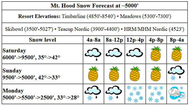
Hey skiers and snowboarders! If you want to hit the slopes this weekend, today is definitely going to be better than tomorrow: we’ve got Pineapple Express on the calendar for all of Sunday with up to 4” of rain in the forecast. Mixed precip (probably) Monday is followed by snow Monday night (hopefully), a decent pow day Tuesday, and warm, dry weather for the rest of the week.
Saturday started with a bit of drizzle, so you can expect wet packed groom today. It was transitioning towards granular yesterday, but wasn’t there yet. If I were going up today, I’d be waxing for the conditions – it definitely got sticky yesterday. Anyway, dry weather for the morning gives way to drizzle this afternoon and heavy rain tonight. The snow level will be 6000′ early and will eventually rise to 9500′ overnight. Temps rise from the mid 30s to the low 40s with the arrival of the Pineapple Express. A trace of rain is forecast during the day. That’s followed by approximately 1.5” rain tonight. Wind: WSW 25-35 this morning, SW 30-50 this afternoon, and WSW 45-55 after midnight.
Windy, rainy weather continues all day Sunday. Temps, rain, and wind taper off overnight. The snow level will be 9500′ in the morning, 6500′ in the afternoon, and down around 5000′ in the evening and night. Temps will be in the low 40s early and will drop to 32-34F in the evening. About 2.5” rain is forecast during the day. We then see about 0.3” mixed precip followed by 0.1” to 0.2” water equivalent (WE) of snow for an inch or two of new. The combo of dropping temps and wind could cause icing on lifts overnight. Wind: WSW 45-55 all day, WSW 40-45 in the evening, and SW 15-25 after midnight.
Another round of mixed precip is forecast on Monday as temps hover right around freezing at 5000′. A low passing somewhere offshore will drive the weather on Monday. As of this morning, it’s unclear exactly where that low will pass. If it comes close, we’re going to have some truly extreme wind. Given the uncertainty, it’s not really possible to make a reliable prediction at this point. Generally speaking, we’re likely to see mixed precip during the day followed by moderate to heavy snow overnight. Wind speeds look low enough for lifts to run during the day, but it’s possible they’ll ramp way up overnight and turn the incoming snow into windslab and sastrugi and also knock down trees and generally cause chaos. We’ll keep an eye on this and see what changes in the next couple of days. Moving on… Tuesday could be a pow day. Temps should stay below freezing, and the sun should come out.
Starting Wednesday, we’re looking at a few days of warm, sunny weather. Temps will definitely be above freezing, and they could reach 50F at times. Models hint that we’ll be back to cooler weather next weekend with snow piling up. That’s all for now. Have a great day on the slopes!
Liking this forecast?
GORGE WIND FORECAST

Hi friends! Rain is the big weather highlight for the next few days, but there will be a little wind mixed in. There’s a slight chance of very wet westerlies out east on Sunday with strong morning westerlies out east on Tuesday. Maybe the timing will shift and give us a better shot at this? Saturday starts with easterlies in the 10-15mph range at the usual spots: Viento, Stevenson, Iwash (Rooster) Rock. The wind goes calm midday and stays that way. River flow over the last 24 hours was 98-172kcfs, river temp is 37.58F, and high temp forecast is 52F with rain in the afternoon.
Sunday brings a frontal system through. This combines with strong upper-level wind. The combo could set off some far eastern Gorge wind (perhaps Arlington to Boardman) at gusty 23-26, but even if that happens, it’ll be super rainy. Areas west of Viento, and potentially Viento, should also see gusty westerlies at maybe 17-20mph along with pouring rain. Between Swell and Blalock, the wind should stay calm or nearly so. High temp: 55F and pouring rain. Monday brings another round of rain with easterlies peaking at 25mph at both Stevenson and Iwash mid-morning. The wind fades in the afternoon. Overnight an offshore low with strong upper-level wind sets off some eastern Gorge westerlies. Timing, strength, and likelihood of lasting into Tuesday are all unclear at this point. Cross your fingers! Stay safe on the river. See you out there soon.
BARE BONES HOOD RIVER WEATHER FORECAST
Partly to mostly cloudy sky this morning turns cloudy this afternoon and adds rain tonight. Temps start in the upper 30s and rise to the low 50s. Light east wind. No rainbows. Sunday will be rainy add day and dry after midnight. Temps start in the mid 40s and rise to the mid 50s. Light to moderate westerlies. 26% chance of rainbows. Monday will be rainy all day and dry overnight. Temps start in the low 40s and rise to the low 50s. Light easterlies. 38% chance of rainbows.
TEMIRA’S AWESOME TRAVEL ADVISORY SERVICE
HYPERLOCAL WEATHER FORECAST FOR THE COLUMBIA GORGE
THE DALLES, HOOD RIVER, WHITE SALMON, TROUT LAKE, STEVENSON, CASCADE LOCKS, PARKDALE, ODELL, HUSUM, BZ, MILL A, WILLARD, GOLDENDALE, RUFUS, ARLINGTON, boardman
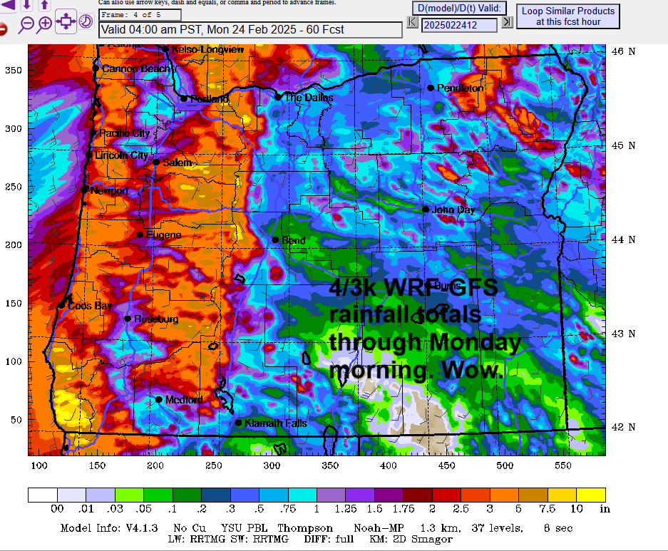
Good morning, neighbors! We’re in the calm before the Pineapple Express this morning. It’s actually kinda nice out there – dry, moist, and bright. Dry weather lasts most of the day for many and all day for most. That’ll give you time to GSD (get shit done) before the torrential rain arrives tonight. Looking at the high-res 4/3k WRF-GFS, we’ve got rain totals through Monday morning from 0.3” near Dufur to 3” near Cascade Locks and up to 8” or more along the most favored slopes of the Cascades. Wow. Before we dive in…
glenwood & tatas eootd
Glenwood is cloudy this morning with a temp of 35F and a dewpoint of 27F. TATAS Executive Order Of The Day (wonky one): when the Gini coefficient climbs above 0.35, the government shall take steps to take it back below 0.35. This shall also take into account the 90/10 ratio, which must remain below 6.3 (where it was at in 1970). As the 90/10 ratio is currently around 13, and the Gini coefficient is around 0.42, Congress better get their butts in action. What the hell am I talking about? Measures of income inequality.
saturday
Moving on from measures to weathers… we’re right on the edge of a truly impressive, moderate-to-strong atmospheric river, aka, the Pineapple Express. Areas west of Lyle stay dry until 4pm or so. Areas east of Lyle stay dry until maybe 10pm or so. Exception: High Prairie, Appleton, Centerville, etc., where the rain will start up prior to sunset, probably. This evening, the rain turns torrential west of Hood River and anywhere west of the Cascade Crest. Heavy rain extends to Lyle or so. Sherman county will be wetter than south Wasco, which will be somewhat rain shadowed. Wind today: calm most places except Stevenson/Iwash where the wind will be light easterly turning westerly overnight. High temps max in the low 50s along the Nch’i Wana, and the snow level rises to 9500′
sunday
Pouring rain continues all day Sunday, all the way to sunset, west of The Dalles. West of Hood River and in the Cascade hills, the best word for it is “torrential”, but that’s only because I don’t have a wetter word. At times, rainfall could exceed 0.25”/hour, perfect for running and singing in the rain! SW/Sherm/Gilliam Counties will all get a drenching on Sunday too. Overnight, the rain tapers off and leaves most of us mostly dry prior to the next system Monday. Sunday’s wind: west at 15-25 west of Viento and east of the John Day River-Blocking Construction Object which is about 10 miles east of Amayah’s, the location formerly known as Biggs. Calm wind will be found in between those spots expect in the hills, where there will be increasingly strong WSW wind the higher you go.
Look at attached map for rain totals through Monday morning.
monday
Next up: another wet system Monday daytime. This one extends the moisture, yet again, way out east and into Idaho. This system is associated with an offshore low that hasn’t quite decided what path to take. Some lows, like some people, just take longer to settle on a path. For now, let’s just say we’ll see some rain along with moderate (20-25mph) east wind. Overnight, depending on where it goes, we could see very strong westerlies, but there’s too much uncertainty to make a call. High temp: 53F with the sky becoming partly cloudy late in the day.
tuesday and beyond
Dry, cool weather is in the cards for Tuesday. After that, things warm up, the sun (probably) comes out, and we might just reach 60 degrees for the second half of next week. If that does indeed happen, and models are pretty sure we’ll be in the 55-60F range in the lowlands, enjoy it. Wet, cooler weather returns next weekend. Safe travels. -TATAS
HEY! DON’T STOP READING! Is this community-focused forecast helpful to you? It sure is! It takes me a couple hours a day to write. Please join your friends and neighbors in contributing to keep it going. Venmo: @thegorgeismygym PayPal: twomirrors@gmail.com USPS: Temira / PO Box 841 / Hood River, Oregon 97031 You can test out the forecast subscription for a few days for free by clicking this link: https://subscribepage.io/YhevGc
