

GORGE WIND FORECAST
today’s gorge wind forecast
Hi friends! You’ll be happy to know that another windy day is on tap for Saturday. Westerlies persist for the extended time frame with the lightest day of the bunch being Monday. Lots of uncertainty is in the cards for Tuesday as we wait to see how max temps will play out. Wednesday’s looking like a sure thing: strong-enough offshore high pressure combines with a solid west-side marine layer and almost 100 degrees of heat out in the desert. It’s almost certain to be a nuker. Pencil it in if that’s your thing.
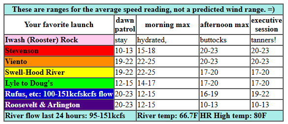
Saturday kicks off with pressures of 30.22/30.12/30.13 for gradients of 0.10 (PDX-DLS) and E 0.01 (DLS-PSC). Stay between Stevenson and Mosier, or perhaps Rowena late, for the best results today. Also, don’t forget about the CGW2 swap meet this morning at Lot 1 on the Hood River waterfront. Have you renewed your CGW2 membership yet this year? If not, get on it right now and support the organization that supports Gorge windsport access.
On to the forecast: TJ’s Dawn Patrol was 19-22mph between Viento and Swell with 13-16ish pretty much everywhere else. Marine clouds filled The Hole (the zone west of Swell), and a few little fluffy clouds extended past Hood River. Expect a bit of up-and-down to the wind until the marine layer burns back just a little bit. Thanks to that marine layer, we’ll see Viento-Mosier build to 22-25mph this morning with 17-20mph from Lyle to Doug’s and 14-17mph at Stevenson and areas between Avery and Arlington. When the marine clouds burn off in the metro area, Swell dips to gusty 17-20mph. Other locations between Stevenson and Mosier should hold at 20-23. Between Lyle and Doug’s, you’ll find 17-20mph this afternoon. East of there: we’ll have upper teens this morning, but the wind drops quickly. Late in the day, westerlies pick up to 19-22 from Avery to Rufus with less to the east. River flow over the last 24 hours was 95-151kcfs (100-151kcfs at Rufus), river temp is 66.7F, and high temp forecast is 80F for Hood River.
RIVER FLOW FOR SITES BETWEEN AVERY (EAST OF THE DALLES) AND RUFUS: CLICK HERE FOR JOHN DAY DAM FLOW.
RIVER FLOW FOR SITES BETWEEN STEVENSON AND DOUG’S BEACH (WEST OF THE DALLES): CLICK HERE FOR THE DALLES DAM FLOW

tomorrow’s gorge wind forecast
We’ll lose the marine clouds on Sunday, but we’ll still have some wind. Expect 18-21mph from Viento to Swell for Dawn Patrol with 11-14mph at Stevenson and also from Hood River to Mosier. The wind holds a few hours then dips to 15-18mph from Stevenson to Mosier as the metro area heats. Models like the idea of an evening rebound to 17-20mph between Stevenson and Mosier with 14-17mph between Lyle and Avery. High temp: 86F for Hood River.
extended Gorge wind forecast
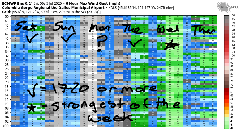
Another warm, sunny, no-marine-cloud day is forecast for Monday. Westerlies start at 18-21 from Viento to Swell, drop to 14-17, and potentially return at 20mph is in the evening between Stevenson and Rufus with 14-17 at Arlington. Turning our attention to Tuesday, we see some uncertainty. We’ll definitely have westerlies, but the strength is in question. In our favor: 11 degrees of cross-Cascade temperature difference. Working against us: a lack of marine clouds. For now, let’s call it 20mph or more focused between Stevenson and Mosier in the morning and potentially filling in to Rufus and Arlington in the afternoon. The GFS is super enthusiastic about Tuesday evening, but the ECMWF ensembles aren’t nearly as excited.
All the models and all the members of the ensembles are stoked on Wednesday – those models, like me, are happiest when it’s nuking. We’re looking at 30mph+ all through the Gorge on Wednesday. With unseasonably strong upper-level support, the Maryhill stretch of the river is likely the spot to be. Uncertainty ramps way up on Thursday as the range of possible temps increases. It’s still very likely we’ll see 17-20mph or more. Friday’s uncertainty is even greater, so I’ll leave it here for now. Have a great day on the river today. If you’re at the Hatch, park tight and allow others to double-park you. Make sure there’s room for everyone who wants to play, and be kind. Don’t be the person who makes someone’s day unpleasant – be the person who makes someone’s day better!
Was that helpful? I knew it was! Guess what? All of this crucial work – from your personal wind and snow reports to the invaluable TATAS updates – is made possible by my relentless efforts. Maintaining this labor of love isn’t easy. Each daily forecast takes hours. Website hosting, weather model access, and back-end admin work takes time and money. That’s where you come in.
YOUR CONTRIBUTION MAKES A DIFFERENCE
- SUPPORT ACCURATE, HYPER-LOCAL WEATHER FORECASTING
- ENABLE ACCESS FOR ALL, EVEN THOSE WITH LESS MEANS
- SUPPORT A COOL HUMAN WHO WORKS HARD SO YOU CAN PLAY
Take a moment to click one of the buttons below. Donate $19.99 or more (how much does this forecast enhance your life?) and get the email in your inbox. Whether it’s a renewing subscription (auto-renew) or a one-time donation, every contribution makes a real difference. Help me keep this labor of love alive, so we can all continue playing, commuting, and living in the Gorge with peace of mind and the best weather forecasts possible. Thank you!


Hood River, Oregon 97031


JONES BEACH, SAUVIE ISLAND, & COAST FORECAST
Wind northerly unless otherwise indicated. For coast, it’s North/Central/South with the “central” at approximately Florence. Swell forecast from NWS for central coast. Jones: westerly unless otherwise stated. Sauvie Island: northerly unless otherwise stated. Saturday: 20/20-25/25, NW swell 3′ at 12 seconds. Sunday: 20/25/30-35, W 4′ @ 9. Monday: 20/20/25, W 4′ @ 8. Jones Saturday: 20-23. Sunday: 19-22. Monday: 20-23. Sauvie Island Saturday: 16-19 > 5pm. Sunday: 16-19. Monday: 15-18.
BARE BONES HOOD RIVER WEATHER FORECAST
Mostly clear sky this morning will be clear this afternoon. Temps start in the upper 50s and rise to 80. Moderately strong westerlies. No rainbows. Sunday will be mostly clear with a few high clouds. Temps start in the mid 50s and rise to the mid 80s. Moderate westerlies. No rainbows. Monday will be sunny. Temps start in the upper 50s and rise to the lo w90s. Moderate westerlies. No rainbows.
TEMIRA’S AWESOME TRAVEL ADVISORY SERVICE
HYPERLOCAL WEATHER FORECAST FOR THE COLUMBIA GORGE
THE DALLES, HOOD RIVER, WHITE SALMON, TROUT LAKE, STEVENSON, CASCADE LOCKS, PARKDALE, ODELL, HUSUM, BZ, MILL A, WILLARD, GOLDENDALE, RUFUS, ARLINGTON, boardman
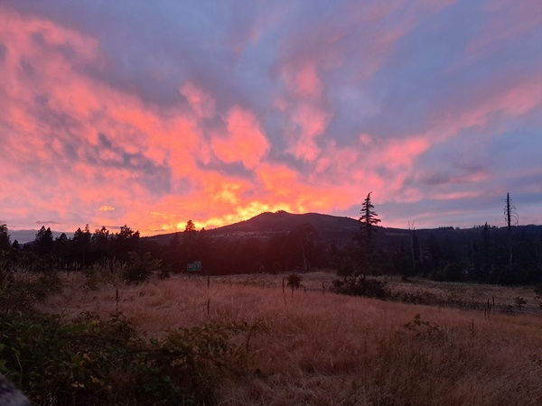
Good morning, neighbors! A warming trend begins today and peaks on Monday and Tuesday. We’ll lose 10-20 degrees (they’ll probably be behind your couch, where everything eventually ends up) between Tuesday and Wednesday resulting in a super-windy day on Wednesday. A couple cooler days (80ish) for the middle of next week give way to (probably) warmer weather starting next Friday. Other than the possibility of a little western Gorge (west of Wyeth) drizzle Wednesday, there’s no sign of rain in the near future. Next chance of an epic sunset like last night’s sunset: uncertain, thanks to a lack of high clouds. Fingers are crossed – sunsets are Ma Nature’s fireworks. Also Ma Nature’s fireworks: orgasms. Go have yourself one today!
Today’s gorge weather forecast and Glenwood’s start to the day
Saturday looks pretty darn nice. Not as nice as a fresh-baked sour cherry pie, but definitely as nice as a fresh-baked chocolate chip cookie. Up in Glenwood this morning on the Camas Prairie, folks are using a 44 degree morning to bake pies. For me. Clearly they are baking me pies. The rest of us start the day in the 50s (mostly) with some upper 40s scattered about Parkdale, where Ellisa is baking me a pie too! Temps today warm up to 80 (west), 85 (The Dalles), and 88 (out where the watermelons grow and the cowboys roam). West wind will be 20-25mph most of the day from Stevenson to Mosier with 20mph from mid-morning on east of Mosier to The Dalles. Farther east: less wind today. Best part of today, other than folks baking me pies? Clouds west of Underwood for a few hours this morning. Otherwise: clear and sunny. Because summer.
sunday’s gorge weather forecast
Another five degrees of heat is forecast on Sunday after a 55ish degree, clear morning. Temps rise to 85 (west), 90 (The Dalles) and 92 (watermelon zone). Westerlies will be 20mph all pretty much all day between Stevenson and Hood River with 15-20mph from Mosier to The Dalles and far less wind to the east.
monday’s gorge weather forecast
Thanks to low humidity, we’ll stick with relatively low (50-something) morning temps on Monday, but we’ll add 5 more degrees of heat in the afternoon. Westerlies will be 15-20mph all day west of Lyle and will spread east to Rufus at 20mph in the evening. Things turn real hot in the desert on Tuesday, far too hot to attempt any pie baking – Pasco’s forecast is 104. The Dalles: upper 90s. Hood River: low 90s. Westerlies persist, thanks to the temp difference, at 15-20mph.
extended gorge weather forecast
Okay, enough with the heat. Wednesday sees the high temps drop 10-20 degrees. This results in 1) happier people; 2) very strong west wind; 3) extreme fire danger; and 4) Wind Johnny stoke level rising off the charts, which results in a positive feedback loop of the wind getting stronger and stronger until the Wind Johnnies enter a bliss state, achieve access to higher realms, become enlightened, and disappear from this mortal plane leaving a bunch of very expensive Sprinter Vans scattered about the Gorge. Or something like that.
A couple days of this somewhat cooler weather for Wednesday and Thursday is followed by warmer weather (probably – there’s lots of uncertainty in the forecast) for the end of next week and next weekend. And so the cycle continues. Temps go up. Temps go down. Glenwood starts chilly no matter what. People bake me pies. I eat a slice and share the rest. Safe travels. -TATAS
HEY! DON’T STOP READING! Is this community-focused forecast helpful to you? It sure is! It takes me a couple hours a day to write. Please join your friends and neighbors in contributing to keep it going. Venmo: @thegorgeismygym PayPal: twomirrors@gmail.com USPS: Temira / PO Box 841 / Hood River, Oregon 97031 You can test out the forecast subscription for a few days for free by signing up below. Easy! Do it!
