

GORGE WIND FORECAST
today’s gorge wind forecast
Hi friends! It was so fun to play with you on the river yesterday! It’s Saturday, and today’s Gorge wind forecast is for another round of westerlies. This one likely requires a bit of driving for the most consistent wind. Westerlies continue on Sunday, and then we enter a two-day recovery period before another round of westerlies on Wednesday.
Let’s dive in to today’s forecast. 6am pressures were 30.09/29.95/29.88 with lingering clouds from yesterday’s front and support from an offshore high based near California. An incoming system well offshore stirs things up this afternoon and decreases quality. Intermittent drizzle is likely EAST of The Dalles into early afternoon. Today’s probable focus for strongest wind: Mosier to Rufus.
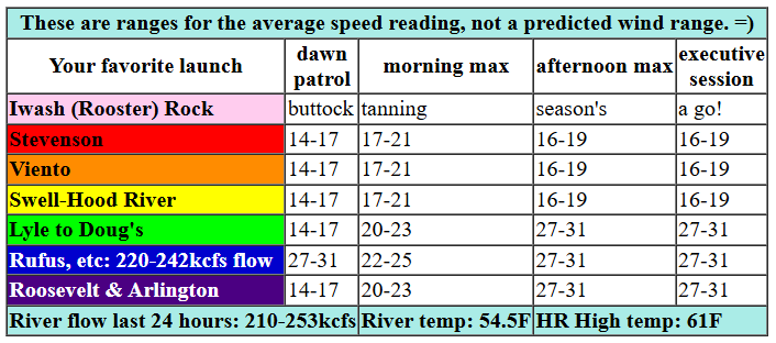
All that said… we started the day with westerlies in the teens to low 20s under the clouds and mid 20s near Rufus with teens farther east. For the morning, we’ll have clouds on the west side with 17-20 from Stevenson to Viento, gusty 14-17 from Swell to Mosier (a short period of 17-21 is possible), and 22-25 from Lyle to Rufus. For the afternoon, the Stevenson to Hood River zone will be gusty 16-20ish. From Mosier (or maybe Lyle) to Rufus, westerlies rise to 27-31. Arlington may also join at that pace, but it may also be in the 23-26 range along with Threemile. Remember that those eastern Gorge sensors read high compared to Swell – 23-26 out there is like 19-22 at Swell. River flow over the last 24 hours was 210-253kcfs, river temp is 54.5F, and high temp forecast is 61F at both Hood River and Arlington.

tomorrow’s gorge wind forecast
On Sunday, we’ll have middling offshore high pressure and middling thermal assistance. From early morning into early afternoon, westerlies hold at 18-21ish from Stevenson to Doug’s. As the pattern settles in Sunday afternoon, Swell to Hood River will be 17-20ish. From Mosier to Doug’s, we’ll see 23-26. East of there: not much at all. High temp: 66F with clearing sky.
extended Gorge wind forecast
High pressure settles in for Monday and Tuesday leaving us with clear sky and light/variable or east wind. On Wednesday, an approaching cooler system (details unclear) sets us up for a big thermally-driven afternoon. While there will be some dynamics that lessen results, results still look excellent: 27-31 with the potential for more in select areas. Ensembles have been trending UPWARD in wind speeds – always a good thing. And ensembles are 95% in on a big westerly day. Also a good thing. Go ahead and clear your afternoon. Beyond Wednesday, uncertainty increases, so let’s leave it there for now. See you on the river!
Was that helpful? I knew it was! Guess what? All of this crucial work – from your personal wind and snow reports to the invaluable TATAS updates – is made possible by my relentless efforts. Maintaining this labor of love isn’t easy. Each daily forecast takes hours. Website hosting, weather model access, and back-end admin work takes time and money. That’s where you come in.
YOUR CONTRIBUTION MAKES A DIFFERENCE
- SUPPORT ACCURATE, HYPER-LOCAL WEATHER FORECASTING
- ENABLE ACCESS FOR ALL, EVEN THOSE WITH LESS MEANS
- SUPPORT A COOL HUMAN WHO WORKS HARD SO YOU CAN PLAY
Take a moment to click one of the buttons below. Donate $19.99 or more (how much does this forecast enhance your life?) and get the email in your inbox. Whether it’s a renewing subscription (auto-renew) or a one-time donation, every contribution makes a real difference. Help me keep this labor of love alive, so we can all continue playing, commuting, and living in the Gorge with peace of mind and the best weather forecasts possible. Thank you!


Hood River, Oregon 97031


MT HOOD WEATHER FORECAST
Good morning skiers and snowboarders! This is the last snow forecast for the season – from today on, things are looking mostly sunny and mostly dry on the mountain. With all the upcoming clear nights, we should see tons of great corn snow for both lift serve at Timberline and earn-your-turns elsewhere. Have a great summer, you snow fiends, and I’ll see you next fall for another round of Mt. Hood weather forecasts!
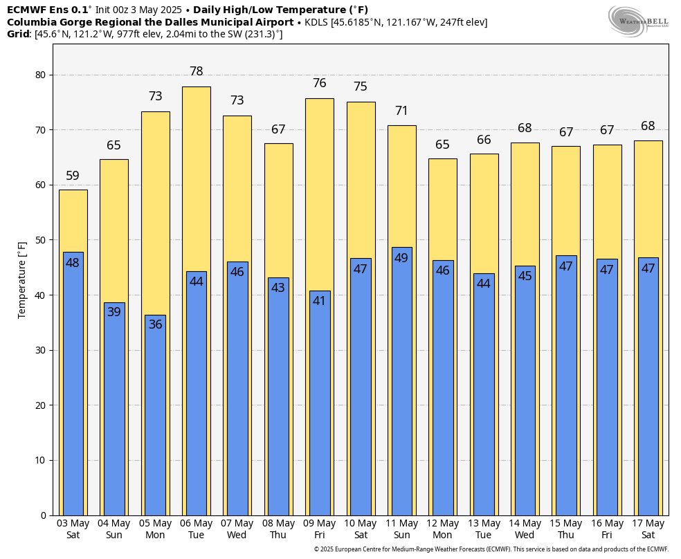
Saturday on Mt. Hood will be a mixed bag, but thankfully forecast precip amounts have dropped to near-nothing. The snow level will be around 4000′ all day (temps at 5000′ dropping from 35F to 30F late) with a trace of wet snow. I’d prefer zero, because Meadows employee ski day is Sunday and I want epic corn snow! Anyway, today’s conditions are spring slush thanks to overnight cloud cover that prevented the snow from refreezing. Clouds stick around all morning and start to burn off this afternoon. Wind will be NW 20-25 this morning, WNW 25-30 this afternoon, and NW 25-30 overnight. Today is Pond Skim day at Meadows – if that’s your thing, head on up!
Sunday kicks off clear and subfreezing with temps in the upper 20s. The free air freezing level will be 3000′ in the morning and 5500′ in the afternoon with temps in the mid to upper 20s early and mid 30s in the afternoon. Wind will be NW 25-30 in the morning, NW 20-25 in the afternoon, and NE 20-25 after midnight. That wind should actually help the snow hold a bit longer. It should be excellent corn conditions. Monday and Tuesday look sunny and warm with easterlies at 20-25mph – that’s not quite enough to cause problems, thankfully. A system on Wednesday cools things down but doesn’t bring any snow. All right y’all – have a great spring, summer and fall!
JONES BEACH, SAUVIE ISLAND, & COAST FORECAST
Wind northerly unless otherwise indicated. For coast, it’s North/Central/South with the “central” at approximately Florence. Swell forecast from NWS for central coast. Saturday: NW10/NW10-15/N25-30, W swell 7′ @ 11 seconds. Sunday: 20/25/35+, W 7′ @ 12. Monday: 20/20-25/30+, W 4′ @ 10. Jones Saturday: 14-17. Sunday: 20-23. Monday: 19-22. Sauvie Island Saturday: NW 12-15. Sunday: N 18-21. Monday: N 17-20.
BARE BONES HOOD RIVER WEATHER FORECAST
Clouds this morning and partly cloudy this afternoon. Temps start in the low 50s and rise to the low 60s. Moderate westerlies. No rainbows. Sunday will be partly cloudy then sunny. Temps start in the low 40s and rise to the mid 60s. Moderate westerlies. No rainbows. Monday will be sunny. Temps start near 40 and rise to the mid 70s. Light and variable wind. No rainbows.
TEMIRA’S AWESOME TRAVEL ADVISORY SERVICE
HYPERLOCAL WEATHER FORECAST FOR THE COLUMBIA GORGE
THE DALLES, HOOD RIVER, WHITE SALMON, TROUT LAKE, STEVENSON, CASCADE LOCKS, PARKDALE, ODELL, HUSUM, BZ, MILL A, WILLARD, GOLDENDALE, RUFUS, ARLINGTON, boardman
Good morning, neighbors! Is cool and cloudy your thing? Make the most of today – with the exception of next Wednesday, we’re heading into an extended period of generally warm and generally sunny weather. Know what that means? Today, being cool and cloudy, is the best weather for fucking! Get on it! But use protection and keep yourself and your partner safe and unimpregnated (assuming there are sperm and eggs involved in this fucking). There’s some slight frost potential tonight, and possibly again next Wednesday night. We’ll dive into that more in a bit.
glenwood and today’s gorge weather
We start the weekend by checking in with Glenwood: 47F and breezy to kick off Saturday. From my vantage point, it looks partly to mostly cloudy there to start the day, and yep, I’m pretty sure I see someone making the Beast With Two Backs. Today’s an interesting one in weather land – models have potential drizzle EAST of The Dalles and in SW/Sherman Counties through early afternoon. West side: just cloudy. Temps max around 60 degrees everywhere today. Westerlies will be 15-20mph west of Lyle and 25-35mph from Lyle to Rufus with 20-25 near the Arlington Triangle. Overnight, clouds clear from east to west but linger along the Cascade crest.
tomorrow’s gorge weather forecast
This sets us up for a slight frost potential on Sunday morning in clear, calm areas. Glenwood, obviously, being as cold as a warlock’s man-tit, is almost certain to dip below freezing on Sunday morning. With NW wind aloft and clouds on the west side, many other areas are going to sneak by frost-free. Parkdale would normally be at risk, but if the clouds hold as forecast, it’ll be safe. Coldest wind-protected spots near The Dalles and Mosier could see a light frost. Along the Columbia: west wind combines with dewpoints in the mid 30s to keep frost out of the picture. If that didn’t apply to you and you just want the weather, read this: skies clear during the day on Sunday. Temps max in the mid 60s. Wind will be 15-20mph west of Mosier and 25-30mph from Mosier to The Dalles. East of there, the wind drops from 15mph in the morning to 10mph or less in the afternoon. Exception: between Avery and Rufus, we could see the wind stick around.
monday’s gorge weather and beyond
Overnight Monday, clear sky and east wind puts a few places at risk for frost. Thinking of spraying Monday or Tuesday? Get it early. Easterlies pick up to 10-20mph in the hills. Expect warm, sunny weather both days Riding your bike? Yield to the space-suit folks protecting their orchards from bugs and baddies. Despite the offshore wind (easterly), these days look decent for naked tanning at Iwash Rock, but not fucking at Iwaash Rock, because that’s not nice. Nobody wants to see you doing that in public. They only want to see you doing that on OnlyFans. Now that the sun goes down late, you can stop on your way home from your city job for a short bit of nudity before you settle in for the commute through the beautiful Gorge. Just remember to put your clothes back on before driving home because nobody from WSP or OSP wants to see your Arlington Triangle or Iwash. Our next chance for some clouds (but probably not any moisture) is Wednesday, when an approaching system gives us strong west wind and a few degrees less warmth. Beyond that, temps bounce around between 65F and 75F for the next 10 days with lots of sunshine. Your garden (and mine, of course) will be very, very happy. Safe travels. -TATAS
HEY! DON’T STOP READING! Is this community-focused forecast helpful to you? It sure is! It takes me a couple hours a day to write. Please join your friends and neighbors in contributing to keep it going. Venmo: @thegorgeismygym PayPal: twomirrors@gmail.com USPS: Temira / PO Box 841 / Hood River, Oregon 97031
