Support it with a contribution!

Thank you for using this forecast. Writing it takes 60-120 minutes a day; I can only keep it going with your generous financial support. Make a contribution or subscribe and get it in your inbox with bonus material. What’s that cost? Not $99 a year. Nope. Not $49. Contribute $19.99 or more, and you’re on the list for a year. People are added to this list on Thursday and Sunday. Thanks for your patience! Click below to contribute and keep the forecast going for everyone, nearly every day. Please include your email address in your contribution – PayPal/Venmo do not tell it to me!
Click here to use your PayPal
Venmo: @theGorgeismyGym
Snail Mail: Temira Lital, PO Box 841, Hood River, Oregon 97031
(note: I am not a non-profit entity. The only way to accept credit cards with a user-defined amount is to use the ‘donate’ button. Thanks for understanding!)
Auto-renewing subscription. New! Awesome!
The Forecast
| 4a-8a | 8a-12p | 12p-4p | 4p-8p | 8p-4a | |
|---|---|---|---|---|---|
| Saturday 6500-7000′ |
 |
|
 |
|
 |
| Sunday 6500′->1000′ |
|
|
|
 |
 |
| Monday 1000′->0′ |
 |
|
|
|
|
Mt. Hood Weather Forecast
Mellow weather on Saturday gives way to mellow daytime weather on Sunday and stormier weather Sunday night. By Monday mid-morning, the mountain should be back to sunshine. That sticks around, most likely, through next week.
Let’s look at Saturday. Bring sunglasses to look around. Sunshine’s the plan until mid-afternoon when high clouds arrive. The free air freezing level (FAF) will be 6500-7000′ all day. Wind: SW 10-20 all day and W 20 after midnight.
Sunday starts high overcast. Snow moves in around sunset. The snow level will be 6500′ in the morning, 5500′ when the weather system hits, and will drop to 1000-1500′ overnight. Models disagree on snow totals: they’re calling for anything from 0.5” water equivalent (WE) to 1.3” WE between Sunday afternoon and Monday morning. Adding in the strong west wind gets us above the minimum. Let’s go with 0.6” to 0.9” WE for 6-9” fresh snow at 5000′. Wind: W 20 prior to dawn, SW 5-10 in the morning, WSW 30-40 in the afternoon, W 45-50 overnight for a blizzardy night, and NW 25-35 after midnight.
Monday starts off with lingering flurries. Those could stick around despite dry air thanks to orographic assistance. Call it intermittent flurries and sunbreaks with up to 1” new snow during the day. The snow level will be 1000-1500′ falling to 0-1000′ overnight. Wind: NW 25-35 in the morning, NW 25-30 in the afternoon, and NW 10-15 after midnight.
Note on wind speeds. Different wind directions are experienced in different ways on Mt. Hood. For example, west wind at 50mph will hit the slopes and exposed ridges at W 50. SW 50 may hit the ridges at SW 50, but will likely only be SW 20 below tree line. Hence the ranges for wind. Depends where you are on the mountain. Hopefully that helps clarify.
Gorge Wind Forecast
Ripping easterlies (46-67mph according to iWind/iKite) start the day. They’ll back off to 20-30mph this afternoon at both Stevenson and Rooster. River flow is 150kcfs, river temp is 37F, and high temp forecast is 35F. Sunday starts with E 15-20 at Rooster and 10-15 at Stevenson. The wind turns calm midday and switches to westerly in the afternoon: 10-15 west of Cascade Locks and 5-10 east of Biggs. High temp: mid 30’s. Monday starts with W 20-30 at Viento and 15-20 west of Swell with 14-17 from Swell to Arlington. Midday: 20-23 from Stevenson to Rufus with 10-13 at Arlington. Light westerlies stick around for Tuesday.
Coast, Jones, Coast
Done until spring, unless there’s an obvious Coast or Sauvie’s or Jones day.
Hood River Weather Forecast
Nothing this morning. Nothing later. Temps will be in the low-mid 30’s all day. Light easterlies. No rainbows. Sunday will be Nothing. Precip moves in late afternoon as… who knows. Temps will be in the low-mid 30’s early and low-mid 30’s later. Calm wind. No rainbows. Monday will be mostly cloudy and then partly cloudy. Temps will be in the mid 30’s early and low 40’s in the afternoon. Light to moderate westerlies. 64% chance of rainbows.
Looking for a complete Columbia Gorge forecast? Looking for more humor in your weather? Obscenities? You’re looking for my TATAS: Temira’s Awesome Travel Advisory Service on Facebook.
Cycling
FREEZE-THAW ALERT: if you notice that temps were below freezing last night and will be above freezing today, don’t ride any trail that’s not under a tree canopy. If you do so, you WILL do significant damage. DON’T DO IT! Plentiful rain recently means most tree-covered trails are muddy. Please don’t ride them either. If you do, you’ll be doing significant and possibly permanent damage. No really, please don’t. There are lots of gravel roads and lots of pavement you can ride instead. Enjoy!
Local Events
Please let me know about events. I often only hear about them if you folx let me know!
Ferment’s Tuesday night 4-mile walk/run is back. Meet there at 6pm. At 7:15am on Wednesdays, there’s a run from the White Salmon Bakery. There’s a night-lit shop mountain bike ride with the Mountain View Cycles crew at Syncline on Wednesday evenings at 5:45pm.
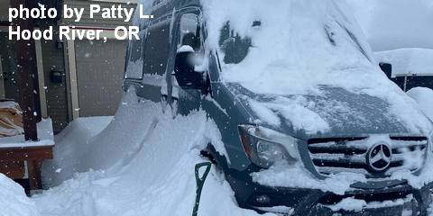
Sprinter Van of the Week!
 Click here for the Sprinter Van map of the world!!!
Have an awesome day!
Click here for the Sprinter Van map of the world!!!
Have an awesome day!