MT. HOOD WEATHER FORECAST

Hey skiers and snowboarders! Dry, mostly-sunny weather continues for the long haul. By “long haul”, I mean probably all the way through this upcoming week. After that, ensembles signal the potential for some precipitation, but there’s so much range in the offerings that it’s not really possible to make a reliable forecast. So, let’s stick with what we do know: lots of sunshine, slowly warming slope-side temps, and consistent frozen granular groom.
SATURDAY
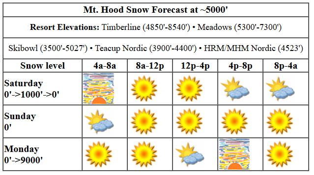
Saturday will have plenty of sun, but there will also be high clouds in the mix. If this timing is just right, we’ll get a stellar mountain sunrise. The free air freezing level will be 0′ this morning, around 500-1000′ this afternoon, and definitely back down to 0′ tonight. Temps at 5000′ start in the upper teens and rise to the upper 20’s this afternoon before plummeting overnight thanks to dry air and radiational cooling. Today’s wind: variable to 15 this morning, variable to 10 this afternoon, and N 10 overnight.
Liking this forecast?
SUNDAY
Sunday starts partly cloudy and cold. By afternoon, we’ll have sunshine. The free air freezing level will be 0′ pretty much all day. Temps are going to be tricky to predict thanks to overnight cloud cover and a mismatch between east side temps and west side temps. Let’s just say temps will be all over the place, but they almost certainly won’t be above freezing! Wind will be N 10+ (north wind does funny things) in the morning, NE 10-20 in the afternoon, and E 15-20 after midnight.
MONDAY AND BEYOND
Monday starts clear and turns partly high overcast. Clear sky returns overnight. The free air freezing level starts at 0′ and rises to 9000′ in the afternoon. Temps at 5000′ will be bouncing around in the morning as cold east side air and warm west side air battle it out. Afternoon sees temps rise to the upper 30s. Wind: E 15-20 in the morning, variable to 10 in the afternoon, and W 25 overnight.
Warm, sunny weather then dominates the picture through at least Thursday. There’s some hint, definitely not a unanimous hint, of a return to snowy weather starting Friday, but there’s also potential for next weekend to remain dry. In the meantime… you’ll definitely be able to get your fill of sunshine by heading to the mountain this week. Have fun!
Was that helpful? I knew it was! Guess what? All of this crucial work – from your personal wind and snow reports to the invaluable TATAS updates – is made possible by my relentless efforts. Maintaining this labor of love isn’t easy. Each daily forecast takes hours. Website hosting, weather model access, and back-end admin work takes time and money. That’s where you come in.
YOUR CONTRIBUTION MAKES A DIFFERENCE
- SUPPORT ACCURATE, HYPER-LOCAL WEATHER FORECASTING
- ENABLE ACCESS FOR ALL, EVEN THOSE WITH LESS MEANS
- SUPPORT A COOL HUMAN WHO WORKS HARD SO YOU CAN PLAY
Take a moment to click one of the buttons below. Donate $19.99 or more (how much does this forecast enhance your life?) and get the email in your inbox. Whether it’s a renewing subscription (auto-renew) or a one-time donation, every contribution makes a real difference. Help me keep this labor of love alive, so we can all continue playing, commuting, and living in the Gorge with peace of mind and the best weather forecasts possible. Thank you!


Hood River, Oregon 97031


GORGE WIND FORECAST

Hi friends! Chilly easterlies are in the cards for many days this week, starting with today. If you’re going out, do be careful. It’s going to be quite cold. Saturday opens up with pressure of 30.42/30.56 for an east gradient of 0.14. Easterlies rise to 35-40mph at Iwash (Rooster) and 25-30mph at Stevenson this morning before dropping this afternoon. The day finishes with 20-25mph at Stevenson and 35mph at Iwash. River flow over the last 24 hours was 100-142kcfs, river temp is 42.44F, and high temp forecast is 39F with sun in the morning and high clouds later.
Sunday starts with E 25mph at Iwash and E 15mph at Stevenson. The wind slowly rises during the day. It finishes up with 25-30mph at Stevenson and 30-35mph at Iwash. High temp: 37F and sunny. Monday brings morning wind at 50mph at Iwash and 35mph at Stevenson. This holds until early afternoon, at which point Stevenson drops to 20-25mph and Iwash drops to 35-40mph. Models hint at the possibility of afternoon westerlies at 15-20ish on Tuesday, easterlies Wednesday and Thursday, and another potential round of westerlies on Friday (when I”ll be headed off on retreat for five days). Keep in mind that temps are quite cold out there. Hypothermia is a real possibility. Dress extra warmly, and keep an eye on your buddies.
BARE BONES HOOD RIVER WEATHER FORECAST
Partial Nothing this morning turns clear later. Temps start in the mid 20s and rise to the upper 30s. Light easterlies. No rainbows. Sunday will be partly Nothing then sunny. Temps start in the mid 20s and rise to the mid-upper 30s. Light easterlies. No rainbows. Monday will be partly Nothing then high overcast. Temps start in the low 20s and rise to the mid 30s. Easterlies. No rainbows.
TEMIRA’S AWESOME TRAVEL ADVISORY SERVICE (DETAILED COLUMBIA GORGE WEATHER FORECAST)

Good morning, neighbors! Cool, sunny weather is what you get for much of the next week. Next chance for rain or snow or anything wet falling from the sky is next Friday, at the earliest. More than likely, it’ll be longer. Buck up, buttercup. It’s time for a round of Vitamin D!
GLENWOOD THIS MORNING
But first… our morning Glenwood report. It’s 17 degrees Farenheit with a dewpoint of 13 degrees. That beats out the next closest competitor, Trout Lake, where it’s 17 degrees with a dewpoint of 15. Congratulations, Glenwood, for another bitterly cold morning! Now, we return to our discussion of sunshine and Vitamin D.
TODAY
With these chilly temps, I wish you good luck exposing any skin to the D-producing rays of Sol. That’s Vitamin D, not “D”. You will not grow a bunch of dicks from your skin if the sun’s rays touch it. Or maybe you will. Go try it out and see! Temps today max out in the upper 30s along the river. Easterlies will be 40mph or so near Iwash (dick) Rock and 20-30mph near Stevenson. Sure, we might have a little Nothing near the river in the morning, but the sun’ll come out this afternoon.
SUNDAY
A nearly identical day is forecast on Sunday. It starts colder: mid 20s are likely even in the lowlands. It finishes up sunny with mid to upper 30s. Wind will be E 25-35mph near Iwash. At Stevenson, you’ll have a tolerable 15mph in the morning and a blustery 25-30mph east breeze in the afternoon.
MONDAY
Repeat all of this Monday: partial Nothing early, sun with a few high clouds later. Morning temps could be in the low 20s near the river, and highs may only make it to the mid 30s. Easterlies start at 50mph near Iwash and 35mph near Stevenson. They drop about 10mph in the afternoon.
WEDNESDAY, THURSDAY, ETC.
Similar weather is in the cards for Wednesday and Thursday. Tuesday could see a brief period of west wind swing through, but that really won’t result in much change in the overall Nothing/sunny/chilly pattern. Changes are possible in this pattern starting Friday, but changes are far from guaranteed; plenty of ensemble members drag this dry, high-pressure-ridging setup on into next weekend.
Eventually the weather will change, as do all things. And realizing that is one of the secrets to a less stressful, less painful life. There’s your wisdom for today. Safe travels. -TATAS
HEY! DON’T STOP READING! Is this community-focused forecast helpful to you? It sure it! It takes me a couple hours a day to write. Please jump in a contribute to keep it going. Venmo: @thegorgeismygym PayPal: twomirrors@gmail.com USPS: Temira / PO Box 841 / Hood River, Oregon 97031 You can test out the forecast subscription for a few days for free by clicking this link: https://subscribepage.io/YhevGc


