

GORGE WIND FORECAST
If you’re still seeing yesterday’s and it’s after 9am, try opening this in an incognito window
Saturday’s gorge wind forecast
Hi friends! We’ve got easterlies this weekend, and they’ll be strong enough to get you on the water. But before we talk about that, let’s talk about the Whoopdee trail work party on Sunday morning. Now that the trail is twice as long, the builders need twice as much help. Please be there if at all possible!
Okay, on to the forecast. This one is for Saturday and Sunday, as it’s not going to change.
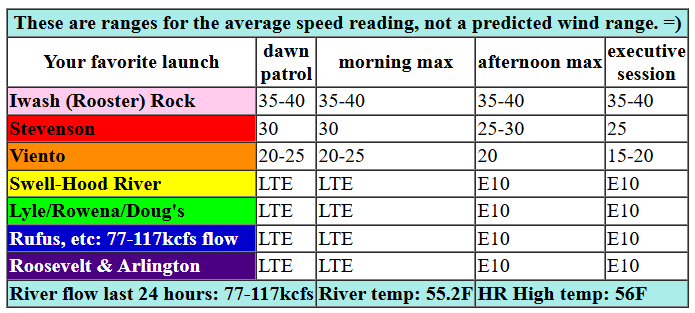
We have a 0.11 offshore gradient this morning, and wind will (mostly) be confined to the river and not spilling over the Cascades. This sets us up for morning wind at 35-40mph at Iwash, 30mph at Stevenson, 20mph at Viento, and (eventually) 10-15mph from Hood River eastward. After 1pm, the wind drops a little: 35-40mph at Iwash, 25mph at Stevenson, and 15-20mph at Viento with 10mph to the east. River flow over the last 24 hours was 77-117kcfs, river temp is 55.2F, and high temp forecast is 56F.
RIVER FLOW FOR SITES BETWEEN AVERY (EAST OF THE DALLES) AND RUFUS: CLICK HERE FOR JOHN DAY DAM FLOW.
RIVER FLOW FOR SITES BETWEEN STEVENSON AND DOUG’S BEACH (WEST OF THE DALLES): CLICK HERE FOR THE DALLES DAM FLOW

Sunday’s gorge wind forecast
Sunday looks very similar to Saturday both in the wind strength and wind duration. With the inversion slightly lower in elevation, the wind will be somewhat more confined to the lowlands. This gives us a shot at 5mph more than Saturday. High temp: 56F under high overcast sky.
extended Gorge wind forecast
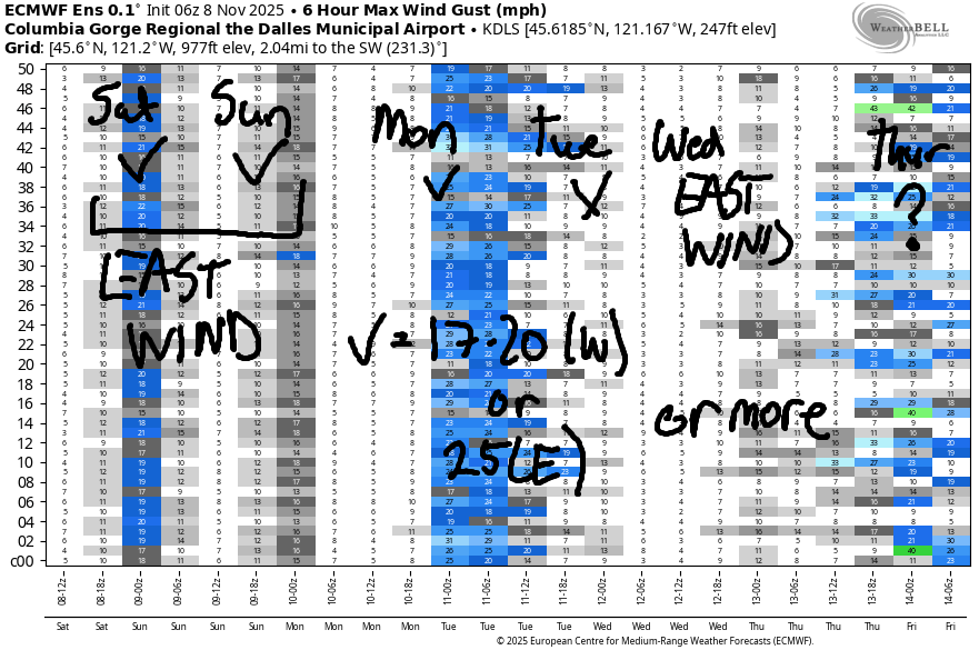
Monday starts with light east wind and quickly switches to light west wind. A cold front will push inland during the day, and high pressure will build offshore. This sets us up for an early afternoon round of 19-22mph from Stevenson to The Dalles. As the clouds and (potentially) drizzle move inland in the afternoon, the west side drops to 14-17mph and areas from The Dalles to Arlington climb to 19-22mph. High temp: 63F with high clouds early and low clouds later.
Light/variable wind is currently Tuesday’s forecast. Easterlies return on Wednesday with 30mph or so at Iwash as a low pressure system moves up the coast. Models hint at the possibility of west wind Thursday or Friday, but they’re not exactly optimistic about it. Don’t pencil anything in yet. Have a lovely day on the Nch’i Wana today and tomorrow!
Was that helpful? I knew it was! Guess what? All of this crucial work – from your personal wind and snow reports to the invaluable TATAS updates – is made possible by my relentless efforts. Maintaining this labor of love isn’t easy. Each daily forecast takes hours. Website hosting, weather model access, and back-end admin work takes time and money. That’s where you come in.
YOUR CONTRIBUTION MAKES A DIFFERENCE
- SUPPORT ACCURATE, HYPER-LOCAL WEATHER FORECASTING
- ENABLE ACCESS FOR ALL, EVEN THOSE WITH LESS MEANS
- SUPPORT A COOL HUMAN WHO WORKS HARD SO YOU CAN PLAY
Take a moment to click one of the buttons below. Donate $19.99 or more (how much does this forecast enhance your life?) and get the email in your inbox. Whether it’s a renewing subscription (auto-renew) or a one-time donation, every contribution makes a real difference. Help me keep this labor of love alive, so we can all continue playing, commuting, and living in the Gorge with peace of mind and the best weather forecasts possible. Thank you!


Hood River, Oregon 97031


MT HOOD SNOW FORECAST

Hi skiers and snowboarders! Still not much going on, but our Mt Hood snow forecast models are optimistic about snow returning to the slopes (and maybe enough for another round of grooming at Teacup) starting next Friday. For Saturday, we have sunshine in the morning and high clouds in the afternoon. The free air freezing level will be 12,000′ this morning and 14,000′ overnight, but radiational cooling should refreeze whatever snow there is. Wind today: SE 15-20mph all day becoming S 5-15mph overnight.
Sunday looks high overcast. The free air freezing level will be above 12,000′ all day at 850mb temps rise from 11C to 16C. Expect high temps at 5000′ to rise to the upper 50s! Wind: S 5-15mph in the morning, SW 10-15 in the afternoon, and W 15-20 overnight. Monday starts high overcast and adds a little drizzle in the afternoon. The snow level will be over 12,000′ all day, but temps drop from 13C to 4C over the 24 hour period. Wind: W 15-20 in the morning, NW 20-25 in the afternoon, and W 15-20 overnight. Dry weather is forecast Wednesday. Uncertainty increases for the latter half of the week, but precipitation looks likely starting Thursday or Friday. A good portion of this periods looks to bring snow, rather than rain. Fingers crossed!!!
BARE BONES HOOD RIVER WEATHER FORECAST
Nothing this morning. High clouds later. Temps start in the upper 30s and rise to the mid 50s. Light easterlies. No rainbows. Sunday will be high overcast. Temps start in the upper 30s and rise to the mid 50s. Light easterlies. No rainbows. Monday will be high overcast then cloudy with a little drizzle. Temps start near 40 and rise to the low 60s. Light easterlies early. Moderate westerlies in the afternoon. 81% chance of rainbows.
TEMIRA’S AWESOME TRAVEL ADVISORY SERVICE
HYPERLOCAL WEATHER FORECAST FOR THE COLUMBIA GORGE
THE DALLES, HOOD RIVER, WHITE SALMON, TROUT LAKE, STEVENSON, CASCADE LOCKS, PARKDALE, ODELL, HUSUM, BZ, MILL A, WILLARD, GOLDENDALE, RUFUS, ARLINGTON, boardman

Good morning, neighbors! Nice weekend on tap here in the Gorge: plenty of sunshine, dry weather for the whole weekend, and high temps in the 50s. Next round of rain arrives in the form of a little drizzle Monday and takes the shape of heavier rain at the end of the week and next weekend. Snuggled in there are plenty of dry days to get shit done outside!
Glenwood this morning and today’s Gorge weather forecast
Like today! Yay! Today’s a great day to build a massive compost pile! Morning weather includes a textbook Nothing along the river and clear sky away from it. Just a few areas are frosty this morning: Dufur, Emerson, and of course Glenwood, which started the day at 26 degrees. All those folks are frantically searching the internet for the Bernie Sanders mitten pattern. Luckily, it’s easy to find! Rest of today: temps rise to the mid 50s as high clouds move in. East wind peaks at 40mph near Iwash (RELEASE THE EPSTEIN FILES) Rock, 30mph near Stevenson, 20mph near Viento, and 10-15mph in the hills and also east of Hood River in the lowlands..
Sunday’s Gorge weather forecast
Increasing high clouds tonight (probably) shoo away any chance of Nothing on Sunday. The day starts in the mid 30s to low 40s and finishes in the mid 50s. In a fun twist, very warm air aloft sends temps above the inversion into the upper 50s. It’ll be a great day for hiking up high. Sunday morning wind will be 45mph at Iwash (NO, REALLY, RELEASE THE FILES) Rock, 30mph at Stevenson, 20-25mph at Viento. Afternoon.: 10mph less at those spots and 10mph east of Hood River.
Monday’s Gorge weather forecast
Monday starts off with high clouds and finishes with a weak weather system. This one drags just a little drizzle as far east as Hood River after noon. Areas east of The Dalles respond by clearing, shaking their heads to dissipate the brain fog, and turning nearly 100% sunny. After a 40 degree (ish) start, temps rise to the low-mid 60s. WARM! Wind: light/variable early and westerly at 20mph or so in the afternoon.
Extended Gorge weather forecast
Dry weather is forecast Tuesday and Wednesday with high temps in the 55-60 degree range. Rain returns on Thursday (probably) and persists all the way through the weekend. Models disagree on how much rain and how much of an atmospheric river tap we’ll have this weekend. Models do like the idea of cooler temps aloft starting Friday. Pass-level snow accumulation looks likely this weekend. Okay, that’s all for today. Safe travels. -TATAS
HEY! DON’T STOP READING! Is this community-focused forecast helpful to you? It sure is! It takes me a couple hours a day to write. Please join your friends and neighbors in contributing to keep it going. Venmo: @thegorgeismygym PayPal: twomirrors@gmail.com USPS: Temira / PO Box 841 / Hood River, Oregon 97031 You can test out the forecast subscription for a few days for free by signing up below. Easy! Do it!
JONES BEACH, SAUVIE ISLAND, & COAST FORECAST
ON WINTER VACATION UNLESS DESPERATELY NEEDED.
